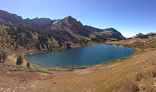
Col de Braus

Last updated
Col de Braus

Col de Braus01.jpg

Hairpin bends on the pass road
Elevation 1,002 m (3,287 ft)
Location Alpes-Maritimes, France
Range Alps

Col de Braus (1002 m) is a high mountain pass in the Alps in the department of Alpes-Maritimes in France.

Mountain pass Route through a mountain range or over a ridge

A mountain pass is a navigable route through a mountain range or over a ridge. Since many of the world's mountain ranges have presented formidable barriers to travel, passes have played a key role in trade, war, and both human and animal migration throughout Earth's history. At lower elevations it may be called a hill pass. The highest vehicle-accessible pass in the world appears to be Mana Pass, located in the Himalayas on the border between India and Tibet, China.

Alps major mountain range system in Central Europe

The Alps are the highest and most extensive mountain range system that lies entirely in Europe, separating Southern from Central and Western Europe and stretching approximately 1,200 kilometres (750 mi) across eight Alpine countries : France, Switzerland, Italy, Monaco, Liechtenstein, Austria, Germany, and Slovenia. The mountains were formed over tens of millions of years as the African and Eurasian tectonic plates collided. Extreme shortening caused by the event resulted in marine sedimentary rocks rising by thrusting and folding into high mountain peaks such as Mont Blanc and the Matterhorn. Mont Blanc spans the French–Italian border, and at 4,810 m (15,781 ft) is the highest mountain in the Alps. The Alpine region area contains about a hundred peaks higher than 4,000 metres (13,000 ft).

Alpes-Maritimes Department of France in Provence-Alpes-Côte dAzur

Alpes-Maritimes is a department of France located in the extreme southeast corner of the country, near the border with Italy and on the Mediterranean coast. Part of the Provence-Alpes-Côte d'Azur region, it had a population of 1,080,771 in 2013.

It connects Sospel and L'Escarène. A railway tunnel has been dug under the pass.

Sospel Commune in Provence-Alpes-Côte dAzur, France

Sospel is a commune (municipality) and former schismatic episcopal seat (1381-1418) in the Alpes-Maritimes department in southeastern France near the Italian border and not far from Monte Carlo.

LEscarène Commune in Provence-Alpes-Côte dAzur, France

L'Escarène is an ancient commune in the Alpes-Maritimes department in southeastern France. It was part of the historic County of Nice until 1860, named Scarena. It was a main stop along the Route de Sel during the 14th, 15th and 16th centuries, between French Provence and Italian Piedmont, on the Nice-Turin road. It was built in the bottom of the valley of Spangle of Escarène at the confluence of the streams of Redebraus and Paillon.

See also

Related Research Articles

Bridger Mountains (Wyoming)

The Bridger Mountains are a short subrange of the Rocky Mountains, approximately 40 miles (64 km) long, in central Wyoming in the United States. The range forms a bridge between the Owl Creek Mountains to the west and the southern end of the Bighorn Mountains to the east. The Wind River passes through the gap between the range and the Owl Creek Mountains. Bridger Creek passes through the gap between the range and the Bighorns. The highest point in the range is Copper Mountain at 8,300 feet (2,500 m).

Greater Caucasus mountain range

Greater Caucasus is the major mountain range of the Caucasus Mountains.

Favre Lake (Nevada) lake in Elko County, Nevada, USA

Favre Lake is a glacial tarn in the Ruby Mountains of Elko County, Nevada, United States. It is within the Ruby Mountains Wilderness, which is administered by the Ruby Mountains Ranger District of the Humboldt-Toiyabe National Forest. The lake is located at the head of Kleckner Canyon, at approximately 40°34.4′N115°23.8′W, and at an elevation of 9511 feet. It has an area of approximately 19 acres, and a depth of up to 45 feet. It is one of the sources of Kleckner Creek, which after exiting the mountains merges with other streams to form the South Fork of the Humboldt River.

Beebe River river in the United States of America

The Beebe River is a 16.7-mile-long (26.9 km) river located in the White Mountains of New Hampshire in the United States. It is a tributary of the Pemigewasset River, part of the Merrimack River watershed.

Zlataritsa Place in Veliko Tarnovo, Bulgaria

Zlataritsa is a small town situated in the central northern part of Bulgaria, located in Veliko Tarnovo Province and close to the towns of Elena, Rodina, Lyaskovets, Strazhitsa and Antonovo. The city is the administrative center of the Zlataritsa Municipality. The climate of Zlataritsa is characteristic for its location north of the Balkan Mountains, which is typically continental. As of December 2009, the town has a population of 2,558 inhabitants.

Trümmelbach Falls waterfall

The Trümmelbach Falls in Switzerland are a series of ten glacier-fed waterfalls inside the mountain made accessible by a tunnel-funicular, built 1913, stairs, and illumination.

Nippletop is a mountain located in Essex County, New York. The mountain is part of the Colvin Range. Nippletop is flanked to the northeast by Dial Mountain. To the east, it faces Dix Mountain across Hunters Pass, and to the west it faces Mount Colvin across Elk Pass.

Krasowo-Wólka is a village in the administrative district of Gmina Nowe Piekuty, within Wysokie Mazowieckie County, Podlaskie Voivodeship, in north-eastern Poland.

Rokszyce Szkolne is a village in the administrative district of Gmina Wola Krzysztoporska, within Piotrków County, Łódź Voivodeship, in central Poland.

Jardin des plantes de Montpellier

The jardin des plantes de Montpellier is a historic botanical garden and arboretum located on Boulevard Henri IV, Montpellier, Hérault, Languedoc-Roussillon, France. It is maintained by the Université Montpellier 1 and open afternoons daily except Monday; admission is free.

Tonquin Pass, 1948 m (6393 ft), is a mountain pass in the Canadian Rockies, linking Tonquin Valley in Jasper National Park, Alberta, to Mount Robson Provincial Park and adjoining areas of British Columbia. It is at the headwaters of Tonquin Creek, which flows into British Columbia. Located on the interprovincial boundary, it is on the Continental Divide.

Protopopinci is a village in the municipality of Dimitrovgrad, Serbia. According to the 2002 census, the village has a population of 55 people.

Bani Dhabyan District is a district of the Sana'a Governorate, Yemen. As of 2003, the district had a population of 16,262 inhabitants.

Catholic Kwandong University (가톨릭관동대학교) is a South Korean university located in Gangneung, Gangwon-do. The university was established in 1954.

Mihklirahu is an island belonging to the country of Estonia.

Djrègbè is an arrondissement in the Ouémé department of Benin. It is an administrative division under the jurisdiction of the commune of Sèmè-Kpodji. According to the population census conducted by the Institut National de la Statistique Benin on February 15, 2002, the arrondissement had a total population of 10,527.

Patakht is a village in Zardalan Rural District, Helilan District, Chardavol County, Ilam Province, Iran. At the 2006 census, its population was 176, in 36 families.

Dragoil is a village in Dragoman Municipality, Sofia Province, western Bulgaria.

Batika Census Town in West Bengal, India

Batika is a census town in Pandua CD Block in Chinsurah subdivision of Hooghly district in the Indian state of West Bengal.

Karboğazı

Karboğazı is a mountain pass in Mersin Province, Turkey.

References

Coordinates: 43°52′18″N7°23′48″E / 43.8717°N 7.3967°E / 43.8717; 7.3967

Geographic coordinate system Coordinate system

A geographic coordinate system is a coordinate system that enables every location on Earth to be specified by a set of numbers, letters or symbols. The coordinates are often chosen such that one of the numbers represents a vertical position and two or three of the numbers represent a horizontal position; alternatively, a geographic position may be expressed in a combined three-dimensional Cartesian vector. A common choice of coordinates is latitude, longitude and elevation. To specify a location on a plane requires a map projection.

Cycling Elevation Profile