The Bernese Alps are a mountain range of the Alps located in western Switzerland. Although the name suggests that they are located in the Berner Oberland region of the canton of Bern, portions of the Bernese Alps are in the adjacent cantons of Valais, Fribourg and Vaud, the latter being usually named Fribourg Alps and Vaud Alps respectively. The highest mountain in the range, the Finsteraarhorn, is also the highest point in the canton of Bern.
Vaud, more formally the Canton of Vaud, is one of the 26 cantons forming the Swiss Confederation. It is composed of ten districts; its capital city is Lausanne. Its coat of arms bears the motto "Liberté et patrie" on a white-green bicolour.

The canton of Fribourg, also canton of Freiburg, is located in western Switzerland. The canton is bilingual, with French spoken by more than two thirds of the citizens and German by a little more than a quarter. Both are official languages in the canton. The canton takes its name from its capital city of Fribourg.

The Sonderbund War of November 1847 was a civil war in Switzerland, then still a relatively loose confederacy of cantons. It ensued after seven Catholic cantons formed the Sonderbund in 1845 to protect their interests against a centralization of power. The war concluded with the defeat of the Sonderbund. It resulted in the emergence of Switzerland as a federal state, concluding the period of political "restoration and regeneration" in Switzerland.

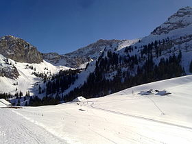
Col des Mosses is a mountain pass in the western Bernese Alps of Switzerland. The pass is located in the municipality of Ormont-Dessous in the canton of Vaud. It links Aigle, to the south in the valley of the Rhone, with Château-d'Œx, to the north in the valley of the Sarine, and is flanked to the west by the Mont d'Or and to the east by the Pic Chaussy.

Caux (Montreux) is a small village in the Canton of Vaud, Switzerland which is part of the Montreux municipality. It looks out over Lake Geneva from an altitude of 1000 meters.

The Rochers de Naye is a mountain of the Swiss Alps, overlooking Lake Geneva near Montreux and Villeneuve, in the canton of Vaud. They lie on the range separating the basin of Lake Geneva from the valley of the Sarine, on the watershed between the Rhone and the Rhine. The mountain is partially located in the canton of Fribourg, the border between the two cantons culminating on a lower summit named Grande Chaux de Naye.

The Vanil Noir is a mountain of the Fribourg Prealps, located on the border between the cantons of Fribourg and Vaud in western Switzerland. Reaching a height of 2,389 metres above sea level, the Vanil Noir is the highest summit of the canton of Fribourg and of the Alpine foothills lying north of the Saane and Simme. It is also the northernmost point in the canton of Vaud above 2,300 metres and the most prominent summit of both cantons.

The Dent de Combette is a mountain of the western Bernese Alps, located north of Rougemont in the Swiss canton of Vaud. It lies south of the border with the canton of Fribourg, on the chain culminating at the Dent de Savigny.
The Dent de Savigny is a mountain of the Bernese Alps, located on the border between the Swiss cantons of Vaud and Fribourg. With an elevation of 2,252 metres above sea level, it one of the highest mountains in the canton of Fribourg.
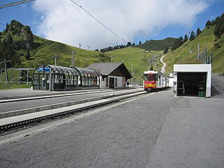
Bretaye is a high mountain pass of the Swiss Alps, located above Villars-sur-Ollon in the canton of Vaud. The pass is connected to Villars by the Bex–Villars–Bretaye railway, which is the second highest railway of the canton after the Montreux–Glion–Rochers-de-Naye railway line. In winter, Bretaye is the main ski area of Villars and a chairlift leads to the summit of Le Chamossaire.

The Vanil des Artses is a mountain of the Swiss Prealps, located west of Montbovon in the canton of Fribourg. It is among a crest of peaks extending south of the Dent de Lys to the Cape au Moine (1,941m) on the border between the Cantons of Vaud and Fribourg, which in turn is just north of the Col de Jaman from Rochers de Naye, all lying on the range between Lake Geneva and the valley of Gruyère.

Mont Pélerin is a mountain of the Swiss Plateau, overlooking Lake Geneva in the canton of Vaud. It lies north of Chardonne, over Vevey, the border with the canton of Fribourg running at the eastern foot of the mountain.

The Cape au Moine is a mountain of the Swiss Prealps, located on the border between the cantons of Vaud and Fribourg. It lies north of the Col de Jaman and south of the Col de Soladier, among of a crest of peaks extending roughly north into Fribourg to the Dent de Lys, on the range between Lake Geneva and the valley of Gruyère.

The Cape au Moine is a mountain of the Bernese Alps, located between L'Etivaz and Les Diablerets in the canton of Vaud. It lies east of La Para.

The Pointe de Paray is a mountain of the Swiss Prealps, located on the border between the cantons of Fribourg and Vaud. It has a height of 2,375 metres above sea level, making it both the third highest summit of the Vanil Noir massif and the canton of Fribourg. The mountain lies approximately halfway between the Vanil de l'Ecri and the Gros Perré.
The Vanil de l'Ecri is a mountain of the Swiss Prealps, located on the border between the cantons of Fribourg and Vaud. Reaching a height of 2,376 metres above sea level, it is both the second highest summit of the Vanil Noir massif and the canton of Fribourg. The mountain lies between the Pointe de Paray and the Vanil Noir.
Mont Vully is a hill of the Swiss Plateau, located between Lake Morat and Lake Neuchâtel in the canton of Fribourg, east of the border with the canton of Vaud.

The col de Soladier is a mountain pass in the canton de Vaud, in Switzerland. It is located 1 km west of a ridge linking the Vanil des Artses and the Cape au Moine, and east of Le Molard.

The Montreux–Lenk im Simmental line is a metre-gauge electric railway line in Switzerland run by the Montreux Oberland Bernois Railway (MOB) and links Montreux on Lake Geneva by way of Les Avants, Montbovon, Rossinière, Château-d'Œx, Rougemont, Saanen, Gstaad and Zweisimmen with Lenk im Simmental. It leads through the cantons of Vaud, Fribourg and Bern. Running along the section between Montreux and Zweisimmen is the GoldenPass Line. The Montreux–Lenk line is one of the oldest electric railways in the country. Its main line, 75.1 km (46.7 mi) in length, is built to the 1,000 mm gauge. At Zweisimmen, passengers may transfer to the Spiez–Erlenbach–Zweisimmen line, a standard gauge line owned by BLS AG. A 12.9 km (8.0 mi) branch line also connects Zweisimmen to Lenk.