
Baja California Sur, officially Estado Libre y Soberano de Baja California Sur, is the least populated state and the last state to be admitted to Mexico, in 1974. It is also the ninth-largest Mexican state in terms of area.

Gustavo A. Madero is the northernmost borough of Mexico City.

Álvaro Obregón is a borough in Mexico City. It contains a large portion of the south-west part of Mexico City. It had a 2020 census population of 759,137 inhabitants and lies at an elevation of 2,319 m. above sea level.
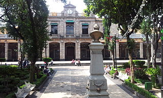
Tlalpan is a borough in Mexico City. It is the largest borough, with over 80% under conservation as forest and other ecologically sensitive area. The rest, almost all of it on the northern edge, has been urban since the mid-20th century. When it was created in 1928, it was named after the most important settlement of the area, Tlalpan, which is referred to as “Tlalpan center” to distinguish it from the borough.
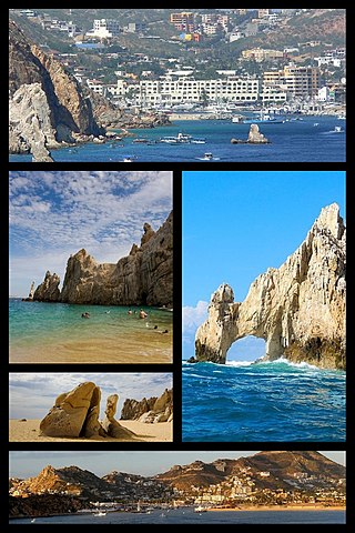
Cabo San Lucas, also known simply as Cabo, is a resort city at the southern tip of the Baja California peninsula, in the Mexican state of Baja California Sur. As of the 2020 Census, the population of the city was 202,694. Cabo San Lucas, together with the famous San José del Cabo are collectively known as Los Cabos. Together, they form a metropolitan area of 351,111 inhabitants.

Naucalpan, officially Naucalpan de Juárez, is one of 125 municipalities located just northwest of Mexico City in the adjoining State of Mexico. The municipal seat is the city of Naucalpan de Juárez, which extends into the neighboring municipality of Huixquilucan.

Federal Highway 1 is a free (libre) part of the federal highway corridors of Mexico, and the highway follows the length of the Baja California Peninsula from Tijuana, Baja California, in the north to Cabo San Lucas, Baja California Sur, in the south. The road connects with Via Rapida, which merges into the American Interstate 5 (I-5) at the San Ysidro Port of Entry, which crosses the international border south of San Ysidro, California.
Mulegé is the northernmost municipality of the Mexican state of Baja California Sur. It is the largest municipality by area in Mexico, with an area of 33,092.20 km2. In the 2020 Census, it had a population of 64,022 inhabitants. Isla Natividad is part of the municipality.

Ciudad Constitución is a city in the Mexican state of Baja California Sur. It is the seat of the municipality of Comondú. As of 2020, the city had a total population of 43,805 inhabitants. Ciudad Constitución is a small city which serves as a gateway to Magdalena Bay.
Jardines del Pedregal or simply El Pedregal is an upscale residential colonia (neighborhood) in southern Mexico City hosting some of the richest families of Mexico. It is also known as the home to the biggest mansion in the city. Its borders are San Jerónimo Avenue and Ciudad Universitaria to the north, Insurgentes Avenue to the east and Periférico to the south and west. Its 510 hectares were a major real estate project undertaken by Mexican modernist architect Luis Barragán.
Huixquilucan Municipality is one of the municipalities in State of Mexico, Mexico. It lies adjacent to the west side of the Federal District and is part of Greater Mexico City but independent of Mexico City itself. The name "Huixquilucan" comes from Nahuatl meaning, "place full of edible thistles".
Federal Highway 1D is a tolled part of the Mexico Federal Highways, paralleling Fed. 1. There are two segments, one in the state of Baja California and another in the state of Baja California Sur.

Lindavista is a neighbourhood in the north of Mexico City, in the administrative district of Gustavo A. Madero. The streets in Lindavista are named after cities in Latin America.

The Colegio Franco Español is a private school in the San Lorenzo Huipulco colonia in Tlalpan, Mexico City. It covers preschool through high school (preparatoria) levels.
The Escuela Preparatoria Tlalpan II "Otilio Montaño" is a senior high school in San Miguel Topilejo, Tlalpan, Mexico City. It is within the Instituto de Educación Media Superior del Distrito Federal (IEMS).

The Instituto de Educación Media Superior de la Ciudad de México is the public preparatoria education system of Mexico City.
Instituto Educativo Olinca, S.C., operating as the Colegio Olinca, is a private school system in Mexico. It serves preschool, kindergarten, primary, middle school (secundaria), and high school (preparatoria).
Vermont School is a private school in Mexico City. It has two campuses: Plantel Pedregal in Jardines del Pedregal, Álvaro Obregón, which has preschool and primary school; and Plantel San Jerónimo, in San Jerónimo, Magdalena Contreras, serving middle school (secundaria) and senior high school (preparatoria).
Colegio El CaminoLos Cabos, BCS is a bilingual, non profit, non sectarian private school located at the base of Pedregal Cabo San Lucas in Los Cabos, Baja California Sur, Mexico. The headmaster for the school is Mr. Heath Sparrow.
Harumi Fujita is a Japanese researcher of Mexican archaeology, who has specialized in pre-classical period of the northern states of Baja California and Baja California Sur. Her research has shown that fishing cultures had arisen in the area at the end of the Pleistocene period, indicating an occupation from at least 11,000 years ago. In a cave shelf known as the Babisuri Shelter, radiocarbon dating indicated the area may have been occupied 40,000 years ago.
