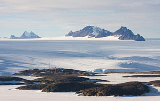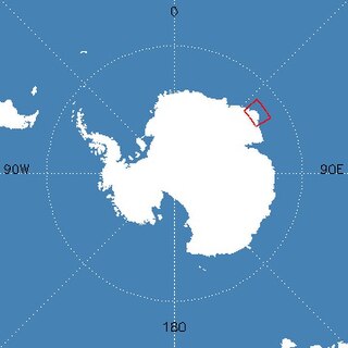
Mawson Station, commonly called Mawson, is one of three permanent bases and research outposts in Antarctica managed by the Australian Antarctic Division (AAD). Mawson lies in Holme Bay in Mac. Robertson Land, East Antarctica in the Australian Antarctic Territory, a territory claimed by Australia. Established in 1954, Mawson is Australia's oldest Antarctic station and the oldest continuously inhabited Antarctic station south of the Antarctic Circle. It houses approximately 20 personnel over winter and up to 53 in summer.


The Framnes Mountains are an Antarctic mountain range consisting of Casey Range, Masson Range, David Range, and Brown Range, and adjacent peaks and mountains. The three major ranges and other lesser features were sighted and named in February 1931 by the British Australian New Zealand Antarctic Research Expedition under Douglas Mawson. This coast was also sighted by Norwegian whalers in the same season. The whole area was mapped in detail by Norwegian cartographers from aerial photographs taken by the Lars Christensen Expedition in January 1937. This overall name for the several ranges was given by Lars Christensen after Framnesfjellet, a hill near Sandefjord, Norway.
Hansen Mountains is a large group of nunataks rising to about 300 m (980 ft) above the Antarctic plateau. The mountains are approximately 89 km (55 mi) south of Stefansson Bay and they extend 40 km (25 mi) from northwest to southeast in Kemp Land, East Antarctica. The Hansen Mountains were first mapped by Norwegian cartographers from air photos taken by the 1936–1937 Lars Christensen Expedition. They were named for H.E. Hansen, the Norwegian cartographer who compiled the maps for this and other Norwegian Antarctic expeditions.
Young Nunataks is a group of nunataks in the Napier Mountains standing 2 nautical miles (3.7 km) south of Mount Elkins, Antarctica. Mapped by Norwegian cartographers from aerial photos taken by the Lars Christensen Expedition, 1936–37. Remapped from aerial photos taken by ANARE in 1956 and named for W.F. Young, electrical fitter at Mawson Station in 1961.
Price Nunatak is a nunatak marking the north end of the Trilling Peaks, 3 nautical miles (6 km) south of Mount Burnett in the Framnes Mountains, Mac. Robertson Land. Mapped by Norwegian cartographers from air photos taken by the Lars Christensen Expedition, 1936–37. Named by Antarctic Names Committee of Australia (ANCA) for H. Price, senior diesel mechanic at Mawson Station in 1959.
Lawson Nunatak is a small tooth-like nunatak lying 2 nautical miles (4 km) southeast of Branson Nunatak in the Masson Range of the Framnes Mountains of Antarctica. The feature was fixed by intersection from trigonometrical stations by Australian National Antarctic Research Expeditions in 1968. It was named by the Antarctic Names Committee of Australia for E. J. Lawson, a diesel mechanic at Mawson Station, who assisted with the survey work in 1967.

Mount Elkins, also known as Jökelen is a dark, steep-sided mountain with three major peaks, the highest 2,300 meters (7,500 ft) above sea level, in the Napier Mountains of Enderby Land. Enderby Land is part of East Antarctica, and is claimed by Australia as part of the Australian Antarctic Territory. The mountain was named after Terence James Elkins, an ionospheric physicist with the Australian National Antarctic Research Expeditions at Mawson Station in 1960.
Mount Gjeita, or Mount Banfield in Australian sources, is the highest peak in the Hansen Mountains, Kemp Land. It is situated about 3 nautical miles to the east of Brusen Nunatak. It was originally mapped and named by Norwegian cartographers working with air photos taken by the Lars Christensen Expedition, 1936-37. In 1959, the Government of Australia named the peak as Mount Banfield after Flight Lieutenant G.A. Banfield, RAAF pilot at Mawson Station.
The Woodberry Nunataks are a group of small nunataks 1 nautical mile north of Lucas Nunatak in the Casey Range of the Framnes Mountains in Antarctica. They were mapped by Norwegian cartographers from air photos taken by the Lars Christensen Expedition of 1936-37 and visited by an ANARE party in 1962. The nunataks were named for B.D. Woodberry, an ionospheric physicist at Mawson Station and a member of the field party.
Boyd Nunatak is a small nunatak 8 nautical miles (15 km) southeast of Mount Caroline Mikkelsen, on the south side of Publications Ice Shelf. It was first mapped by Norwegian cartographers from air photos taken by the Lars Christensen Expedition, 1936–37, remapped by the Australian National Antarctic Research Expeditions, and named by the Antarctic Names Committee of Australia for J.S. Boyd, a physicist at Wilkes Station in 1965.
Branson Nunatak is a nunatak between Mount Burnett and Price Nunatak in the Framnes Mountains, Mac. Robertson Land. It was mapped by Norwegian cartographers from air photos taken by the Lars Christensen Expedition, 1936–37, and named Horntind. It was renamed by the Antarctic Names Committee of Australia for J. Branson, geophysicist at Mawson Station in 1962.
Christensen Nunatak is a nunatak 1 nautical mile (2 km) north of Robertson Island in the Seal Nunataks group, off the east coast of the Antarctic Peninsula. It was discovered in 1893 by a Norwegian expedition under C.A. Larsen, who named it for Christen Christensen of Sandefjord, Norway, a pioneer of modern Antarctic whaling. It was surveyed in 1902 by the Swedish Antarctic Expedition under Otto Nordenskiöld, and in 1947 and 1953 by the Falkland Islands Dependencies Survey.
Watson Nunatak is a nunatak standing between Price and Van Hulssen Nunataks in the Trilling Peaks, Framnes Mountains, in Mac. Robertson Land. It was mapped by Norwegian cartographers from air photos taken by the Lars Christensen Expedition, 1936–37. I was named by the Antarctic Names Committee of Australia (ANCA) for K.D. Watson, a diesel mechanic at Mawson Station who assisted in the Framnes Mountains--Depot Peak survey by ANARE in 1965.
Fischer Nunatak is a nunatak, 750 metres (2,460 ft) high, standing 2 nautical miles (4 km) south of Mount Henderson in the northeast part of the Framnes Mountains, Mac. Robertson Land, Antarctica. It was mapped by Norwegian cartographers from air photos taken by the Lars Christensen Expedition, 1936–37, and named "Sornuten". It was renamed by the Australian National Antarctic Research Expeditions for H.J.L. Fischer, a cook at Mawson Station in 1958.
The Fitzgerald Nunataks are three isolated nunataks 2 nautical miles (4 km) north of Mount Codrington, at the northwest end of the Napier Mountains in Enderby Land, Antarctica. They were mapped by Norwegian cartographers from air photos taken by the Lars Christensen Expedition, 1936–37, and named "Veslenutane". They were photographed from Australian National Antarctic Research Expeditions aircraft in 1956 and renamed by the Antarctic Names Committee of Australia for Brigadier L. Fitzgerald, Director of Survey in the Australian Army, 1942–60.
Lucas Nunatak is a nunatak 1 nautical mile (2 km) south of the Woodberry Nunataks in the Casey Range of the Framnes Mountains, Antarctica. It was mapped by Norwegian cartographers from air photos taken by the Lars Christensen Expedition, 1936–37, and was visited by an Australian National Antarctic Research Expeditions party in April 1962. It was named by the Antarctic Names Committee of Australia for F.M. Lucas, officer in charge at Mawson Station in 1962.
McGrath Nunatak is a ridge-like nunatak at the west end of the Blånabbane Nunataks, standing 7 nautical miles (13 km) southeast of Van Hulssen Nunatak in Mac. Robertson Land, Antarctica. It was mapped by Norwegian cartographers from air photos taken by the Lars Christensen Expedition, 1936–37, and was named by the Antarctic Names Committee of Australia for P.J. McGrath, a radio officer at Mawson Station who assisted in the Australian National Antarctic Research Expeditions' Framnes Mountains – Depot Peak survey during 1965.
Van Hulssen Nunatak is a nunatak at the south end of the Trilling Peaks in the Framnes Mountains, Mac. Robertson Land. It was mapped by Norwegian cartographers from air photos taken by the Lars Christensen Expedition, 1936–37, and was named by the Antarctic Names Committee of Australia (ANCA) for Frits Van Hulssen, a technical officer (ionosphere) at Mawson Station in 1959.


