
The tellurometer was the first successful microwave electronic distance measurement equipment. The name derives from the Latin tellus, meaning Earth.
The tellurometer was the first successful microwave electronic distance measurement equipment. The name derives from the Latin tellus, meaning Earth.
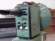
The original tellurometer, known as the Micro-Distancer MRA 1, was introduced in 1957. [1] It was invented by Trevor Wadley of the Telecommunications Research Laboratory of the South African Council for Scientific and Industrial Research (CSIR). He was also responsible for the Wadley Loop receiver, which allowed precision tuning over wide bands, a task that had previously required switching out multiple crystal oscillators. [2]
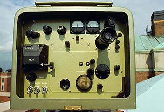
The tellurometer emits a microwave-frequency radio wave. The remote station carries a transponder that reradiates the incoming wave in a similar wave of more complex modulation. The resulting phase shift is a measure of the two-way distance travelled. The results appear on a cathode ray tube with circular sweep. [3]

The tellurometer design yields high accuracy distance measurements over geodetic distances, but it is also useful for second order survey work, especially in areas where the terrain is rough and/or the temperatures extreme. Examples of remote locations mapped using Tellurometer surveys are Adams Bluff, Churchill Mountains, Cook Mountains, Jacobsen Glacier, Mount Albright, Mount Predoehl, Mount Summerson, Sherwin Peak and Vogt Peak. [4]
The instrument penetrates haze and mist in daylight or darkness and has a normal range of 30–50 km but can extend up to 70 km. [5]
The MRB2 or Hydrodist was a marine version that was used in coastal hydrographic surveys and calibrating ships using other survey navigation systems. [5]
They were used by the Army of the Republic of Vietnam in the late 1960s. [6]
Plessey, the British electronics company, formed a new subsidiary known as Tellurometer (Pty) Limited in the 1960s to manufacture the product and to develop and sell derivatives. [5] The company subsequently introduced numerical displays, solid state transmitters, integrated circuits and eventually microprocessors for the product. [5]

Microwave is a form of electromagnetic radiation with wavelengths ranging from about one meter to one millimeter corresponding to frequencies between 300 MHz and 300 GHz respectively. Different sources define different frequency ranges as microwaves; the above broad definition includes both UHF and EHF bands. A more common definition in radio-frequency engineering is the range between 1 and 100 GHz. In all cases, microwaves include the entire SHF band at minimum. Frequencies in the microwave range are often referred to by their IEEE radar band designations: S, C, X, Ku, K, or Ka band, or by similar NATO or EU designations.

Surveying or land surveying is the technique, profession, art, and science of determining the terrestrial two-dimensional or three-dimensional positions of points and the distances and angles between them. A land surveying professional is called a land surveyor. These points are usually on the surface of the Earth, and they are often used to establish maps and boundaries for ownership, locations, such as the designed positions of structural components for construction or the surface location of subsurface features, or other purposes required by government or civil law, such as property sales.
Radio propagation is the behavior of radio waves as they travel, or are propagated, from one point to another in vacuum, or into various parts of the atmosphere. As a form of electromagnetic radiation, like light waves, radio waves are affected by the phenomena of reflection, refraction, diffraction, absorption, polarization, and scattering. Understanding the effects of varying conditions on radio propagation has many practical applications, from choosing frequencies for amateur radio communications, international shortwave broadcasters, to designing reliable mobile telephone systems, to radio navigation, to operation of radar systems.
Super high frequency (SHF) is the ITU designation for radio frequencies (RF) in the range between 3 and 30 gigahertz (GHz). This band of frequencies is also known as the centimetre band or centimetre wave as the wavelengths range from one to ten centimetres. These frequencies fall within the microwave band, so radio waves with these frequencies are called microwaves. The small wavelength of microwaves allows them to be directed in narrow beams by aperture antennas such as parabolic dishes and horn antennas, so they are used for point-to-point communication and data links and for radar. This frequency range is used for most radar transmitters, wireless LANs, satellite communication, microwave radio relay links, satellite phones, and numerous short range terrestrial data links. They are also used for heating in industrial microwave heating, medical diathermy, microwave hyperthermy to treat cancer, and to cook food in microwave ovens.
The Plessey Company plc was a British electronics, defence and telecommunications company. It originated in 1917, growing and diversifying into electronics. It expanded after World War II by acquisition of companies and formed overseas companies.
True-range multilateration is a method to determine the location of a movable vehicle or stationary point in space using multiple ranges (distances) between the vehicle/point and multiple spatially-separated known locations. Energy waves may be involved in determining range, but are not required.

Direction finding (DF), or radio direction finding (RDF), is – in accordance with International Telecommunication Union (ITU) – defined as radio location that uses the reception of radio waves to determine the direction in which a radio station or an object is located. This can refer to radio or other forms of wireless communication, including radar signals detection and monitoring (ELINT/ESM). By combining the direction information from two or more suitably spaced receivers, the source of a transmission may be located via triangulation. Radio direction finding is used in the navigation of ships and aircraft, to locate emergency transmitters for search and rescue, for tracking wildlife, and to locate illegal or interfering transmitters. RDF was important in combating German threats during both the World War II Battle of Britain and the long running Battle of the Atlantic. In the former, the Air Ministry also used RDF to locate its own fighter groups and vector them to detected German raids.
Trevor Lloyd Wadley, was a South African electrical engineer, best known for his development of the Wadley Loop circuit for greater stability in communications receivers and the Tellurometer, a land surveying device.
The Queen Elizabeth Range is a rugged mountain range of the Transantarctic Mountains System, located in the Ross Dependency region of Antarctica.
The Geologists Range is a mountain range about 55 km (34 mi) long, standing between the heads of Lucy and Nimrod Glaciers in Antarctica. Seen by the northern party of the New Zealand Geological Survey Antarctic Expedition (NZGSAE) (1961–62) and named to commemorate the work of geologists in Antarctic exploration.

A laser rangefinder, also known as a laser telemeter, is a rangefinder that uses a laser beam to determine the distance to an object. The most common form of laser rangefinder operates on the time of flight principle by sending a laser pulse in a narrow beam towards the object and measuring the time taken by the pulse to be reflected off the target and returned to the sender. Due to the high speed of light, this technique is not appropriate for high precision sub-millimeter measurements, where triangulation and other techniques are often used.
A scatterometer or diffusionmeter is a scientific instrument to measure the return of a beam of light or radar waves scattered by diffusion in a medium such as air. Diffusionmeters using visible light are found in airports or along roads to measure horizontal visibility. Radar scatterometers use radio or microwaves to determine the normalized radar cross section of a surface. They are often mounted on weather satellites to find wind speed and direction, and are used in industries to analyze the roughness of surfaces.

Stadiametric rangefinding, or the stadia method, is a technique of measuring distances with a telescopic instrument. The term stadia comes from a Greek unit of length Stadion which was the typical length of a sports stadium of the time. Stadiametric rangefinding is used for surveying and in the telescopic sights of firearms, artillery pieces, or tank guns, as well as some binoculars and other optics. It is still widely used in long-range military sniping, but in many professional applications it is being replaced with microwave, infrared, or laser rangefinding methods. Although much easier to use, electronic rangefinders can give away the shooter's position to a well-equipped adversary, and the need for accurate range estimation existed for much longer than electronic rangefinders small and rugged enough to be suitable for military use.
Hans Erich (Eric) Hollmann was a German electronic specialist who made several breakthroughs in the development of radar.

Microwave transmission is the transmission of information by electromagnetic waves with wavelengths in the microwave range of the electromagnetic spectrum. Microwave signals are normally limited to the line of sight, so long-distance transmission using these signals requires a series of repeaters forming a microwave relay network. It is possible to use microwave signals in over-the-horizon communications using tropospheric scatter, but such systems are expensive and generally used only in specialist roles.

Coastal ocean dynamics applications radar (CODAR) describes a type of portable, land-based, High Frequency (HF) radar developed between 1973 and 1983 at NOAA's Wave Propagation Laboratory in Boulder, Colorado. CODAR is a noninvasive system that permits to measure and map near-surface ocean currents in coastal waters. It is transportable and offers output ocean current maps on site in near real time. Moreover, using CODAR it is possible to measure waves heights and it provides an indirect estimate of local wind direction.

Wave radar is a type of radar for measuring wind waves. Several instruments based on a variety of different concepts and techniques are available, and these are all often called. This article, gives a brief description of the most common ground-based radar remote sensing techniques.

Radio is the technology of signaling and communicating using radio waves. Radio waves are electromagnetic waves of frequency between 30 hertz (Hz) and 300 gigahertz (GHz). They are generated by an electronic device called a transmitter connected to an antenna which radiates the waves, and received by another antenna connected to a radio receiver. Radio is very widely used in modern technology, in radio communication, radar, radio navigation, remote control, remote sensing, and other applications.
Length measurement, distance measurement, or range measurement (ranging) refers to the many ways in which length, distance, or range can be measured. The most commonly used approaches are the rulers, followed by transit-time methods and the interferometer methods based upon the speed of light.
The Geodimeter was the first optical electronic distance meter surveying instrument. It was originally developed for measuring the speed of light. It was invented in 1947 by Erik Osten Bergstrand and commercialized in 1953 by the AGA company of Sweden. It was used in the Transcontinental Traverse.