Interstate 76 (I-76) is an Interstate Highway that runs from Interstate 70 in Arvada, Colorado to an intersection with Interstate 80 near Big Springs, Nebraska. All but 3 miles of the road's route is in Colorado.

State Highway 7 is an 81.64 miles (131.39 km) long state highway in the U.S. state of Colorado. It is located in the north-central portion of the state, traversing the mountains on the east of the continental divide south of Estes Park as well as portions of the Colorado Piedmont north of Denver. The northwestern segment of the highway is part of the Peak-to-Peak Scenic Byway and furnishes an access route to Estes Park, Colorado and Rocky Mountain National Park. In its southeast portion it skirts the northern end of the Denver Metropolitan Area, providing an access route connecting Boulder, Lafayette and Brighton with Interstate 25 and Interstate 76.
Interstate 270 (I-270) is a 7-mile-long (11 km) highway in the northeastern part of the Denver–Aurora Metropolitan Area in the U.S. state of Colorado. It overlaps U.S. Highway 36 (US 36) for its entire length. The western terminus of I-270 is at the interchange with I-25 and US 36. It heads eastward to an interchange with I-76, where the mileposts reset because of a previous freeway extension. The freeway heads southeast and comes to meet Vasquez Boulevard, where it enters Commerce City. The road crosses Quebec Street before ending at I-70.

State Highway 16 (SH 16) is a short east–west expressway in El Paso County, south of Colorado Springs. Highway 16 constitutes the westernmost portion of a longer road known as the Mesa Ridge Parkway.

State Highway 178 or SH 178 is a Texas state highway in the city of El Paso in El Paso County maintained by the Texas Department of Transportation (TxDOT). The 3.0-mile (4.8 km) route designated in 1991 connects New Mexico State Road 136 at the New Mexico state line between El Paso and Santa Teresa, NM to a freeway carrying Interstate 10, U.S. Route 85, and U.S. Route 180 on the west side of El Paso. The route together with NM 136 is a major urban roadway connecting an international border crossing with I-10. The route also has an important intersection with SH 20.

State Highway 64 is a 74-mile-long (119 km) two-lane state highway connecting the towns of Dinosaur and Meeker in the western part of the U.S. state of Colorado. It is located in both Moffat and Rio Blanco counties. The western end of SH 64 is part of the Dinosaur Diamond Scenic Byway, while the eastern end is a junction with SH 13 near Meeker, Colorado. Its largest amount of traffic is 6600 near Rangely. It is classified as a Minor Rural Highway by the Colorado Department of Transportation.
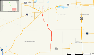
State Highway 109 is a 65.327 mi (105.134 km) long state highway in southeastern Colorado. SH 109's southern terminus is at U.S. Route 160 north of Kim, and the northern terminus a continuation north as Grand Avenue in Cheraw.

State Highway 23 (SH 23) is a 17.7 mi (28.5 km) long state highway in the northeastern corner of Colorado. The southern terminus is at U.S. Route 385 (US 385) in Holyoke, it then travels northeast through Amherst to its northern terminus at the Nebraska state line where it becomes Nebraska Highway 23 (N-23).

State Highway 26 is a 3-mile (4.8 km) long state highway in Denver, Colorado, United States. It follows a portion of Alameda Avenue, stretching east from SH 95 at the west city limits to Kalamath Street within the Interstate 25 (I-25) and U.S. Route 85 interchange. It formerly continued west through Lakewood to US 40 near I-70 exit 259.
State Highway 112 (SH 112) is a 27.802-mile-long (44.743 km) state highway in southern Colorado. Built in 1916 and formally defined in 1922, the route begins at its western end in Del Norte at a junction with U.S. Highway 160 (US 160). From there the road travels east crossing US 285 two miles (3.2 km) west of Center before reaching its eastern terminus at Hooper where it meets SH 17.

State Highway 128 (SH 128) is a 10 mi (16.1 km) long state highway in the Denver, Colorado metro area. SH 128's western terminus is at SH 93 south of Boulder, and the eastern terminus is at Interstate 25 (I-25) in Westminster.

State Highway 59 (SH 59) is a 173.3-mile-long (278.9 km) state highway in eastern Colorado. SH 59's southern terminus is at U.S. Route 40 and US 287 in Kit Carson, and the northern terminus is at US 138 in Sedgwick.

State Highway 21 (SH 21) is an expressway in El Paso County, in eastern Colorado Springs. The highway serves as an eastern bypass for the city of Colorado Springs. Officially, the routing is from SH-16 in the south to Interquest Parkway/ SH 83 in the north.

State Highway 79 (SH 79) is a 23.8 mi (38.3 km) long state highway in Adams and Weld counties in Colorado. The highway is also called "Kiowa–Bennett Road" and "Converse Road". It traverses through remote, open plain. The highway does not pass through any towns. It does service some subdivisions in the area. SH 79's southern terminus is at Interstate 70 (I-70), U.S. Route 36 (US 36), US 40 and US 287 south of Bennett, and the northern terminus is at SH 79 in Prospect Valley.

State Highway 30 (SH 30), alternatively known as Hampden Avenue, is a state route in the independent city of Denver and Arapahoe County. Its west end is at Interstate 25 (I-25) and U.S. Route 285 in Denver and its east end is at Quincy Avenue east of Aurora.

State Highway 263 (SH 263) is a 2.73-mile-long (4.39 km), two-lane state highway located within the city limits of Greeley, Colorado. The average daily traffic of the route, which was recorded in 2008, was about 5700 cars entering at the junction with U.S. Highway 85, and 4700 cars exiting at the intersection with Fern Avenue It is classified as a Major Urban Collector highway by the Colorado Department of Transportation, and does not have any truck limitations.
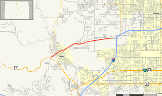
State Highway 58 (SH 58) is a 5.627 mi (9.056 km) state highway in Jefferson County, Colorado. It begins at an at-grade intersection with US 6 and SH 93 in Golden and ends in Wheat Ridge. It is a freeway for its entire length except for its west junction, which is a signal light.

State Highway 42 is a state highway in Boulder County, Colorado, United States. It runs south from SH 7 to Louisville and then east to US 287.

State Highway 224 (SH 224) is a state highway in Adams County, Colorado. SH 224's western terminus is at U.S. Route 36 (US 36) in Western Hills, and the eastern terminus is at US 6 and US 85 in Derby.


