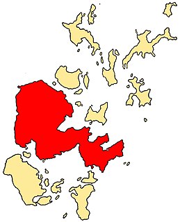
The Mainland, also known as Hrossey and Pomona, is the main island of Orkney, Scotland. Both of Orkney's burghs, Kirkwall and Stromness, lie on the island, which is also the heart of Orkney's ferry and air connections.
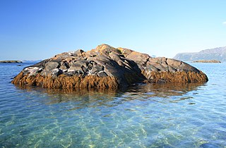
A skerry is a small rocky island, or islet, usually too small for human habitation. It may simply be a rocky reef. A skerry can also be called a low sea stack.

Inishowen is a peninsula in the north of County Donegal in Ireland. Inishowen is the largest peninsula on the island of Ireland.

Enniscrone – also spelt Inniscrone and officially named Inishcrone – is a small seaside town in County Sligo, Ireland. Its sandy beach, tourist campsite, and golf course all attract visitors. As of the 2016 census, the town had a population of 1,156 people.

Ennistymon or Ennistimon is a country market town in County Clare, near the west coast of Ireland. The River Inagh, with its small rapids known as the Cascades, runs through the town, behind the main street. A bridge across the river leads to nearby Lahinch, on the N67 national secondary road. The town is connected to Ennis by the N85, continuing the settlement's main street.

Skerries is a coastal town in Fingal, Ireland. Historically Skerries was a fishing port and later a centre of hand embroidery. These industries declined in the early 20th century, however, and it became both a resort town and a commuter town for Dublin.

Rush, officially an Ros, is a small seaside commuter town in Fingal, Ireland. It was one of the few towns of the historic County Dublin. Rush lies on the Irish Sea coast, between Skerries and Lusk, and has a small harbour. It had a population at the 2011 census of 9,231.

Inishmaan is the middle of the three main Aran Islands in Galway Bay, off the west coast of Ireland. It is part of County Galway in the province of Connacht. Inishmaan has a population of about 183, making it the smallest of the Aran Islands in terms of population. It is one of the most important strongholds of traditional Irish culture. The island is predominantly Irish-speaking and part of the Gaeltacht, though all inhabitants have knowledge of English.

Inisheer is the smallest and most easterly of the three Aran Islands in Galway Bay, Ireland. With about 260 permanent residents, it is the second-most populous of the Arans. Caomhán of Inis Oírr is the island's patron saint. There are five small settlements: Baile Thiar, Chapeltown, Castle Village, Baile an Fhormna and Baile an Lorgain.

The Skerries are a group of sparsely vegetated rocky islets (skerries), with a total area of about 17 hectares lying 3 kilometres (1.9 mi) offshore from Carmel Head at the northwest corner of Anglesey, Wales. The islands are important as a breeding site for seabirds, and they attract divers, who come to visit the numerous shipwrecks. The Skerries Lighthouse sits atop the highest point in the islands.
Ynys Feurig is the name for a set of three small inter-connected low-lying inshore tidal rocky islets, lying off from the west coast of Anglesey, North Wales, just north of the village of Rhosneigr and south of RAF Valley airfield. They are also known by the English name Starvation Island. The islets are accessible from the mainland at mid-to low tide. The clipper Norman Court ran aground nearby, in Cymyran Bay.
The twin villages of Ballineen and Enniskeane in County Cork in Ireland are 43 km (26.72 mi) southwest of Cork City, on the R586 road. Ballineen and Enniskean lie on the River Bandon between Bandon and Dunmanway and the fertile Bandon valley.
Inishark or Inishshark, sometimes called Shark Island, is a small island neighbouring the larger Inishbofin in County Galway, Ireland.

Haulbowline is an island in Cork Harbour off the coast of Ireland. The world's first yacht club was founded on Haulbowline in 1720. The western side of the island is the main naval base and headquarters for the Irish Naval Service, with the eastern side previously used for heavy industry and later redeveloped as a park. Since 1966 the island has been connected to the mainland by a roadbridge.
Newtowncashel is a village located near Lough Ree in County Longford, Ireland. It is within the townland of Cornadowagh. Newtowncashel won the Irish Tidy Towns Competition in 1980.
St Patrick's Island is the most distant of three low-lying uninhabited islets off the headland of Skerries, County Dublin in Ireland. It is an island of low cliffs and lies about 1.5 km from the mainland, with vegetation consisting of grasses, brambles and other species such as hogweed. It is the most important of the three islands for breeding seabirds. Cormorant, Shag and Herring Gull are the most prominent species.

Inis Cealtra, also known in English as Inishcaltra or Holy Island, is an island off the western shore of Lough Derg in Ireland. Now uninhabited, it was once a monastic settlement. It has an Irish round tower, and the ruins of several small churches, as well as four high crosses and a holy well. Despite the lack of population, the cemetery on this island is still in use. Coffins and mourners are transported the short distance from County Clare in small boats. Boat trips can be taken from the harbour at Mountshannon. It is conserved by the East Clare Heritage Centre.

The Abbey River is a distributary arm of the River Shannon that flows around the northeastern, eastern, and southern shores of King's Island, Limerick before rejoining the Shannon at Hellsgate Island. Hellsgate Island is only visible at low tide. It is bridged by the Abbey Bridge, Baals Bridge, the Canal Bridge, Matthew Bridge, O'Dwyer Bridge, and the Sylvester O'Halloran Footbridge.

Inch Island is in Inishowen, County Donegal, Ireland. The island is in Lough Swilly, a sea lough on the northern coast of Ireland.

Inishkeel is a small tidal island and a townland off the coast of County Donegal, Ireland. The closest village on the mainland is Narin.

