Columbia County is a county located in the U.S. state of New York. As of the 2020 census, the population was 61,570. The county seat is Hudson. The name comes from the Latin feminine form of the name of Christopher Columbus, which was at the time of the formation of the county a popular proposal for the name of the United States.

Columbia County is a county located in the north central portion of the U.S. state of Florida. As of the 2020 census, the population was 69,698, up from 67,531 at the 2010 census. Its county seat is Lake City.

Interstate 80 (I-80) is an east–west transcontinental freeway that crosses the United States from downtown San Francisco, California, to Teaneck, New Jersey, in the New York metropolitan area. The highway was designated in 1956 as one of the original routes of the Interstate Highway System; its final segment was opened in 1986. The second-longest Interstate Highway in the United States after I-90, it runs through many major cities, including Oakland, Sacramento, Reno, Salt Lake City, Omaha, Des Moines, and Toledo and passes within 10 miles (16 km) of Chicago, Cleveland, and New York City.

Brooklyn is a village in Jackson County in the U.S. state of Michigan. The population was 1,313 at the 2020 census. It is located in the Irish Hills region of southern Michigan, just north of U.S. Route 12 along M-50. The village is located within Columbia Township.
Canaan is a town in Columbia County, New York, United States. The population was 1,570 at the 2020 census, down from 1,710 at the 2010 census. The town is in the northeastern part of the county.
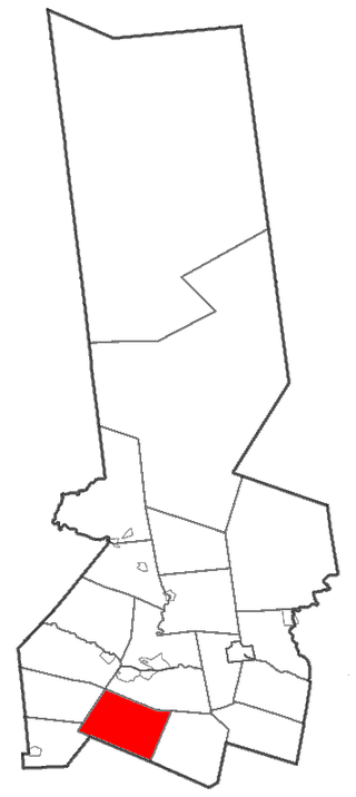
Columbia is a town in Herkimer County, New York, United States. As of the 2010 census, the town population was 1,580. The town is at the southern border of the county and is southeast of Utica.

Warren is a town in Herkimer County, New York, United States. The population was 1,143 at the 2010 census. The town is named after General Joseph Warren, who was killed at the Battle of Bunker Hill. Warren is in the south part of Herkimer County. US 20 passes across the town.

Southeast is a town in Putnam County, New York, United States, so named for its location in the southeastern corner of the county. The population was 18,058 at the 2020 census. The town as a whole is informally referred to as Brewster, the town's principal settlement; the latter is also an incorporated village within the town's borders. Interstate 84, Interstate 684, U.S. Route 202, US Route 6, and NY 22 are the primary routes through the town.

Schodack is a town in Rensselaer County, New York, United States. The population was 12,965 at the 2020 census. The town name is derived from the Mahican word, Escotak. The town is in the southwestern part of the county. Schodack is southeast of Albany, New York.

U.S. Route 2 or U.S. Highway 2 (US 2) is an east–west United States Numbered Highway spanning 2,571 miles (4,138 km) across the northern continental United States. US 2 consists of two segments connected by various roadways in southern Canada. Unlike some routes, which are disconnected into segments because of encroaching Interstate Highways, the two portions of US 2 were designed to be separate in the original 1926 highway plan.

The Canada–United States border is the longest international border in the world. The terrestrial boundary is 8,891 km (5,525 mi) long. The land border has two sections: Canada's border with the contiguous United States to its south, and with the U.S. state of Alaska to its west. The bi-national International Boundary Commission deals with matters relating to marking and maintaining the boundary, and the International Joint Commission deals with issues concerning boundary waters. The agencies responsible for facilitating legal passage through the international boundary are the Canada Border Services Agency (CBSA) and U.S. Customs and Border Protection (CBP).

Mount Colden is the eleventh-highest peak in the High Peaks of the Adirondack Mountains, New York, United States. The peak was named after David S. Colden, an investor in the McIntyre Iron Works, in 1836. The peak was briefly renamed "Mount McMartin" the next year, but the older name persisted. The mountain is known for its distinctive Trap Dike, a large crevice running up the center of the mountain, which can clearly be seen from Avalanche Lake.

The history of post-confederation Canada began on July 1, 1867, when the British North American colonies of Canada, New Brunswick, and Nova Scotia were united to form a single Dominion within the British Empire. Upon Confederation, the United Province of Canada was immediately split into the provinces of Ontario and Quebec. The colonies of Prince Edward Island and British Columbia joined shortly after, and Canada acquired the vast expanse of the continent controlled by the Hudson's Bay Company, which was eventually divided into new territories and provinces. Canada evolved into a fully sovereign state by 1982.
Blake Peak is a mountain located in Essex County, New York. The mountain is named after Mills Blake, Verplanck Colvin’s chief assistant during the Adirondack Survey. It is part of the Colvin Range. Blake Peak is flanked to the northeast by Mount Colvin, and to the southwest by Pinnacle.

Wallface Mountain is a mountain located in Essex County, New York, United States. The mountain is named after the cliff on its southeastern side. Wallface is flanked to the west by MacNaughton Mountain, and faces Mount Marshall to the southeast across Indian Pass.
Coeur Alaska, Inc. v. Southeast Alaska Conservation Council, 557 U.S. 261 (2009), is a United States Supreme Court case that was decided in favor of Coeur Alaska's permit to dump mine waste in a lake. The case addressed tailings from the Kensington mine, an underground mine located in Alaska. The gold mine had not operated since 1928, and Coeur Alaska obtained a permit in 2005 from the United States Army Corps of Engineers (USACE) to dispose of up to 4.5 million tons of tailings in Lower Slate Lake, which is located in a National Forest.
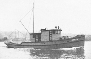
USFS Blue Wing was an American fishery patrol vessel that operated in the waters of the Territory of Alaska. She was part of the United States Bureau of Fisheries (BOF) fleet from 1924 to 1940. She then served as US FWS Blue Wing in the fleet of the Fish and Wildlife Service from 1940 until at least 1951. Before her United States Government service, she was the commercial purse seiner August. In private ownership after the conclusion of her U.S. Government career she was renamed El Don.
