
El Salvador has transport links by road, rail, sea and air.

Armando Calderón Sol was President of El Salvador from 1 June 1994, to 1 June 1999, representing the Nationalist Republican Alliance. He was the first president elected in El Salvador after twelve years of civil war.
Ilopango is a town in the San Salvador department of El Salvador. It is a few miles east of the nation's capital, San Salvador. It is located near Lake Ilopango, the country's largest lake at 72 square kilometers.

San Miguel Tepezontes is a municipality in the La Paz department of El Salvador. It is located in the countryside 25 minutes east of the capital city, San Salvador, and 40 minutes from the International Airport at Comalapa. It overlooks Lake Ilopango, and San Salvador. The municipality has a population of more than 8,000 people, and is a producer of coffee, corn, beans and tropical fruit.
Comalapa is a compound Nahuatl word derived from comalli ("griddle")+"apa", it may refer to any of the following geographical locations:
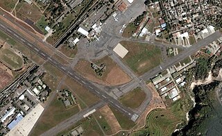
Ilopango International Airport is an airport located on the eastern part of the city of San Salvador, El Salvador, once serving the city as its international airport until it was replaced by the larger and more modern El Salvador International Airport, located about 50 km south of the city. Currently, Ilopango is used for military, air taxi, and charter aviation only. It also holds the annual Ilopango Air Show. The airport is also home to the National Aviation Museum of San Salvador, which is housed in the old terminal building.
Access to drinking water and sanitation in El Salvador has been increased significantly. A 2015 conducted study by the University of North Carolina called El Salvador the country that has achieved the greatest progress in the world in terms of increased access to water supply and sanitation and the reduction of inequity in access between urban and rural areas. However, water resources are heavily polluted and the great majority of wastewater is discharged without any treatment into the environment. Institutionally a single public institution is both de facto in charge of setting sector policy and of being the main service provider. Attempts at reforming and modernizing the sector through new laws have not borne fruit over the past 20 years.

El Salvador International Airport Saint Oscar Arnulfo Romero y Galdámez, , previously known as Comalapa International Airport is an airport that serves San Salvador, El Salvador. It is located in the south central area of the country, in the city of San Luis Talpa, Department of La Paz, and occupies a triangular plain of 2519.8 acres, which borders the Pacific Ocean to the south, to the east with the Jiboa river, and to the northwest with the coastal highway. Being close to sea level, it allows aircraft to operate efficiently at maximum capacity. It is connected to the capital of San Salvador, El Salvador through a modern four-lane motorway, with 42 kilometers travel in an average time of 30 minutes.

San Marcos is a municipality in El Salvador. It is located in a small valley, 5 miles (8 km) southeast of downtown San Salvador. It has a population of 63,209. San Marcos is one of the 14 municipalities which make up the Metropolitan Area of San Salvador, also known as Greater San Salvador.
Fuerte San Francisco are a professional football club based in San Francisco Gotera, El Salvador.
Club Social Deportivo Vendaval is a professional soccer team of the El Salvadorian city of Apopa.
Comalapa is a town and municipality in the Chalatenango Department of El Salvador.
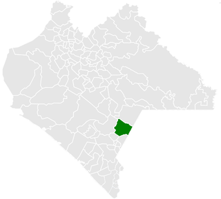
Frontera Comalapa is a town and one of the 119 municipalities of Chiapas, in southern Mexico. It covers an area of 717.90 km².

The RN-5 serves as one of the main highways in the Metropolitan Area of San Salvador. The highway connects the metropolitan area with the El Salvador International Airport, located in San Luis Talpa, La Paz, a municipality that borders with the San Salvador Department. The highway was built to replace the old Carretera al Aeropuerto, a small road that runs on the side of a mountain range, parallel to the Autopista Comalapa. This road has been turned into a scenic road. It overlooks the new RN-5 and the southern hills of the San Salvador Department. The total length of the highway is 40.7 kilometres (25.3 mi). It is currently the only highway that connects to the airport coming from the metropolitan area. Other highways connect with the RN-5 to provide connection to the other departments in the country. The construction of the first Carretera a Comalapa was made in 1980. The construction of the highway began in 2001 and it was completed and inaugurated on November 22, 2002. The part of the highway known as Boulevard de Los Proceres runs through the southern side of the city of San Salvador. The highway is also a vital area in the city. It connects with various restaurants, business centers, and other dealerships.
Club Deportivo Atlético Comalapa is a Salvadoran professional football club based in Chalatenango, El Salvador.

Tourism accounts for a large part of El Salvador's economy. It offers many natural attractions including, beaches, a mild tropical climate and lush landscapes. It also offers an important archaeological and ecological heritage, with colonial and pre-Columbian vestiges, and national reserves.
The Copa El Salvador 2016–17 is the fifth staging of the Copa El Salvador football tournament and the first was played since the 2014–15 edition when the tournament was known as the Copa Presidente.
