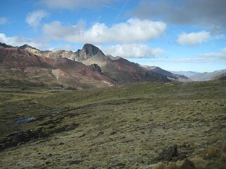
Callangate or Ccallangate is a mountain massif in the Vilcanota mountain range of the Andes in Peru. Its highest point is Collpa Ananta, also known as Chimboya, with an elevation of 6,110 metres (20,046 ft). Another peak in the massif is called Ccallangate. It lies in the Cusco Region, Quispicanchi Province, Ocongate District. Collpa Ananta is the second highest peak in Cusco, and ranks as the 24th highest in Peru.

Ccarhuarazo is a volcano in the Andes of Peru, about 5,112 m (16,772 ft) high. It is located in the Ayacucho Region, Lucanas Province, Chipao District as well as in the Sucre Province, Soras District.
Comercocha is a lake in Peru located in the Cusco Region, Quispicanchi Province, Ocongate District. Comercocha lies southwest of the mountain Callangate of the Vilcanota mountain range.

Ccerayoc is a 5,092-metre-high (16,706 ft) mountain in the Urubamba mountain range in the Andes of Peru. It is located in the Cusco Region, Calca Province, in the districts Calca and Lares. It lies immediately east of Sahuasiray and northeast of Condorhuachana.
Lauricocha is a lake in the Cordillera Blanca in the Andes of Peru. It is located in the Ancash Region, Asunción Province, Chacas District. Lauricocha lies south-west of the lake Yanacocha, south of Paqarisha Lake and north-east of the mountain Pomabamba.

Anticona, also called Ticlio, is a mountain in the Andes of Peru, about 5,150 metres (16,896 ft) high. It is located in the Lima Region, Huarochiri Province, Chicla District, and in the Junín Region, Yauli Province, Morococha District. Anticona lies between the Ticlio mountain pass in the southwest and Yanashinga in the northeast, northwest of a lake named Huacracocha.

Uruashraju or Verdecocha is a mountain in the Cordillera Blanca of the Andes of Peru, about 5,722 metres (18,773 ft) high. It is located in the Ancash Region, Huaraz Province, Olleros District, and in the Huari Province, Chavín de Huantar District. Uruashraju lies south of Huantsán, east of Cashán and Shacsha, and southeast of Lake Tararhua.

Kunka is a mountain in the La Raya mountain range in the Andes of Peru. It is situated at the La Raya Pass and the road and rail which connect Cusco with Lake Titicaca. It is located in the Cusco Region, Canas Province, Layo District, and in the Puno Region, Melgar Province, Santa Rosa District, and about 5,200 metres (17,060 ft) high. Kunka lies southwest of the mountains Yana Khuchilla and Chimpulla. Other neighboring mountains are Huch'uy K'uchu north of it and Hatun Ichhuna Kunka in the south. Between the road and the mountain there is a little lake named Q'umirqucha.

Carhuachuco is a mountain in the Pariacaca mountain range in the Andes of Peru, about 5,507 metres (18,068 ft) high. It is situated in the Junín Region, Yauli Province, in the districts Suitucancha and Yauli. Carhuachuco lies south of the mountain Putka and south-west of the lake Putkaqucha.

Putka is a mountain in the Paryaqaqa mountain range in the Andes of Peru, about 5,300 metres (17,388 ft) high. It is located in the Junín Region, Yauli Province, in the districts of Suitucancha and Yauli, north of Qarwachuku.

Putkaqucha is a mountain in Peru, about 4,800 m (15,748 ft) high, at a lake of that name. The mountain and the lake are located in the Junín Region, Concepción Province, Andamarca District, northeast of the Waytapallana mountain range. The peak of Putkaqucha is south of Utkhu Warqu.

Putkaqucha is a 5,236-metre-high (17,178 ft) mountain in the Waytapallana mountain range in Peru. It is located in the Junín Region, Concepción Province, Comas District, and in the Huancayo Province, on the border of the districts of El Tambo and Quilcas. Putkaqucha lies southwest of Puywan and northwest of Waytapallana and Ch'uspi.
Lake Ancapuachanan is a small lake in the Huaytapallana mountain range in Peru. It is located in the Junín Region, Huancayo Province, El Tambo District. Lake Ancapuachanan is situated north of the lake named Chuspicocha and southwest of Mount Chuspi.

Llamayojcasa, also known as Qochaqollur, is a mountain in the eastern extensions of the Urubamba mountain range in the Andes of Peru, about 4,600 m (15,092 ft) high. It is located in the Cusco Region, Calca Province, Calca District. It lies southeast of Ccerayoc. This is where the archaeological site of Llamayuq is situated.

Coscojahuarina is a 4,623-metre-high (15,167 ft) mountain in the eastern extensions of the Urubamba mountain range in the Andes of Peru It is located in the Cusco Region, Calca Province, Calca District. It lies south of Llamayojcasa and west of the village of Totora.

Yanacucho is a mountain in the Vilcanota mountain range in the Andes of Peru, about 5,000 m (16,000 ft) high. It is situated in the Cusco Region, Canchis Province, Pitumarca District. Yanacucho lies southwest of the mountain named Comercocha and northwest of Cóndor Tuco.

Pucacocha is a 5,320-metre-high (17,454 ft) mountain in the Vilcanota mountain range in the Andes of Peru. It is situated in the Cusco Region, Quispicanchi Province, Marcapata District. Pucacocha lies northeast of Jatunñaño Punta.

Yanacocha is a 5,025-metre-high (16,486 ft) mountain in the Vilcanota mountain range in the Andes of Peru. It is located in the Cusco Region, Canchis Province, Checacupe District. Yanacocha lies southwest of the glaciated area of Quelccaya, north of the Huancane River.

Comercocha is a 5,060-metre-high (16,601 ft) mountain in the Vilcanota mountain range in the Andes of Peru. It is located in the Cusco Region, Canchis Province, Checacupe District. Comercocha lies southwest of the glaciated area of Quelccaya : It is situated south of the Huancane River near a lake named Soracocha.

Quenamari is a 5,054-metre-high (16,581 ft) mountain in the Vilcanota mountain range in the Andes of Peru. It is located in the Cusco Region, Canchis Province, Checacupe District. Quenamari lies southwest of the glaciated area of Quelccaya : It is situated between a mountain named Comercocha in the north and Cuzcoccahuarina in the south, north of the Llanca Mayo.


