
In the United States, a conservation easement is a power invested in a qualified land conservation organization called a "land trust", or a governmental entity to constrain, as to a specified land area, the exercise of rights otherwise held by a landowner so as to achieve certain conservation purposes. It is an interest in real property established by agreement between a landowner and land trust or unit of government. The conservation easement "runs with the land", meaning it is applicable to both present and future owners of the land. The grant of conservation easement, as with any real property interest, is part of the chain of title for the property and is normally recorded in local land records.
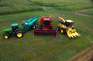
A farm is an area of land that is devoted primarily to agricultural processes with the primary objective of producing food and other crops; it is the basic facility in food production. The name is used for specialized units such as arable farms, vegetable farms, fruit farms, dairy, pig and poultry farms, and land used for the production of natural fiber, biofuel, and other commodities. It includes ranches, feedlots, orchards, plantations and estates, smallholdings, and hobby farms, and includes the farmhouse and agricultural buildings as well as the land. In modern times, the term has been extended so as to include such industrial operations as wind farms and fish farms, both of which can operate on land or at sea.

The United States Department of Agriculture (USDA) is an executive department of the United States federal government that aims to meet the needs of commercial farming and livestock food production, promotes agricultural trade and production, works to assure food safety, protects natural resources, fosters rural communities and works to end hunger in the United States and internationally. It is headed by the secretary of agriculture, who reports directly to the president of the United States and is a member of the president's Cabinet. The current secretary is Tom Vilsack, who has served since February 24, 2021.
An agricultural subsidy is a government incentive paid to agribusinesses, agricultural organizations and farms to supplement their income, manage the supply of agricultural commodities, and influence the cost and supply of such commodities.

In general, a rural area or a countryside is a geographic area that is located outside towns and cities. Typical rural areas have a low population density and small settlements. Agricultural areas and areas with forestry are typically described as rural, as well as other areas lacking substantial development. Different countries have varying definitions of rural for statistical and administrative purposes.

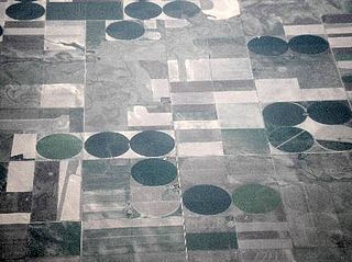
Agriculture is a major industry in the United States, which is a net exporter of food. As of the 2017 census of agriculture, there were 2.04 million farms, covering an area of 900 million acres (1,400,000 sq mi), an average of 441 acres per farm.
Natural Resources Conservation Service (NRCS), formerly known as the Soil Conservation Service (SCS), is an agency of the United States Department of Agriculture (USDA) that provides technical assistance to farmers and other private landowners and managers.
Agribusiness is the industry, enterprises, and the field of study of value chains in agriculture and in the bio-economy, in which case it is also called bio-business or bio-enterprise. The primary goal of agribusiness is to maximize profit while satisfying the needs of consumers for products related to natural resources such as biotechnology, farms, food, forestry, fisheries, fuel, and fiber.

Texas A&M AgriLife Extension Service was formally established in 1915 after the 1914 passing of the Smith-Lever Act and in conjunction with Texas A&M University. Originally named Texas Agricultural Extension Service, then later Texas Cooperative Extension, the name Texas AgriLife Extension Service was adopted on January 1, 2008. A&M was added to the agency name on September 1, 2012 as a result of a Texas A&M University System change to strengthen the association with Texas A&M. The primary mission of AgriLife Extension is to provide educational outreach programs and services to the citizens of Texas. In conjunction with Texas A&M AgriLife Research, the Extension faculty members conduct research and bring practical applications of those research findings to the people of Texas.

Agricultural wastewater treatment is a farm management agenda for controlling pollution from confined animal operations and from surface runoff that may be contaminated by chemicals in fertilizer, pesticides, animal slurry, crop residues or irrigation water. Agricultural wastewater treatment is required for continuous confined animal operations like milk and egg production. It may be performed in plants using mechanized treatment units similar to those used for industrial wastewater. Where land is available for ponds, settling basins and facultative lagoons may have lower operational costs for seasonal use conditions from breeding or harvest cycles. Animal slurries are usually treated by containment in anaerobic lagoons before disposal by spray or trickle application to grassland. Constructed wetlands are sometimes used to facilitate treatment of animal wastes.
The Foreign Agricultural Service (FAS) is the foreign affairs agency with primary responsibility for the United States Department of Agriculture's (USDA) overseas programs – market development, international trade agreements and negotiations, and the collection of statistics and market information. It also administers the USDA's export credit guarantee and food aid programs and helps increase income and food availability in developing nations by mobilizing expertise for agriculturally led economic growth. The FAS mission statement reads, "Linking U.S. agriculture to the world to enhance export opportunities and global food security," and its motto is "Linking U.S. Agriculture to the World."

The Finger Lakes National Forest is a United States National Forest that encompasses 16,259 acres (65.80 km2) of Seneca and Schuyler counties, nestled between Seneca Lake and Cayuga Lake in the Finger Lakes Region of the State of New York. It has over 30 miles (50 km) of interconnecting trails that traverse gorges, ravines, pastures, and woodlands.

Agriculture in Greece is deeply rooted in history, and based on its Mediterranean climate. This practice encompasses a wide array of crops, including olives, grapes, citrus fruits, cereals, and vegetables, with a notable emphasis on olive oil production, establishing Greece as a global leader in this industry. The country's vineyards produce tons of grapes and also yield renowned wines. Greece also produces a wide variety of livestock products. Fisheries are playing an important role while forestry plays a secondary role.

The Tualatin River National Wildlife Refuge is a 1,856 acres (751 ha) wetlands and lowlands sanctuary in the northwestern part of the U.S. state of Oregon. Established in 1992 and opened to the public in 2006, it is managed by the United States Fish and Wildlife Service. Located in southeastern Washington County, 15 miles (24 km) southwest of Portland, the refuge is bordered by Sherwood, Tualatin and Tigard. A newer area, extending into northern Yamhill County, is located further west near the city of Gaston surrounding the former Wapato Lake.
The agricultural policy of the United States is composed primarily of the periodically renewed federal U.S. farm bills. The Farm Bills have a rich history which initially sought to provide income and price support to US farmers and prevent them from adverse global as well as local supply and demand shocks. This implied an elaborate subsidy program which supports domestic production by either direct payments or through price support measures. The former incentivizes farmers to grow certain crops which are eligible for such payments through environmentally conscientious practices of farming. The latter protects farmers from vagaries of price fluctuations by ensuring a minimum price and fulfilling their shortfalls in revenue upon a fall in price. Lately, there are other measures through which the government encourages crop insurance and pays part of the premium for such insurance against various unanticipated outcomes in agriculture.
The National Agriculture Imagery Program (NAIP) acquires aerial imagery during the agricultural growing seasons in the continental United States. It is administered by the USDA's Farm Service Agency (FSA) through the Aerial Photography Field Office (APFO) in Salt Lake City.
Htantabin Township is a township located on the western border of central Yangon Region, Burma (Myanmar). Its administrative seat is Htantabin which is located in the southeastern part of the township on the western bank of the Hlaing River just south of its confluence with the Kokkowa River.
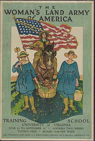
The Woman's Land Army of America (WLAA), later the Woman's Land Army (WLA), was a civilian organization created during the First and Second World Wars to work in agriculture replacing men called up to the military. Women who worked for the WLAA were sometimes known as farmerettes. The WLAA was modeled on the British Women's Land Army.
Real estate is property consisting of land and the buildings on it, along with its natural resources such as growing crops, minerals or water, and wild animals; immovable property of this nature; an interest vested in this (also) an item of real property, buildings or housing in general. In terms of law, real relates to land property and is different from personal property while estate means the "interest" a person has in that land property.
Pacific Forest Trust is an accredited non-profit conservation land trust that advances forest conservation and stewardship solutions. Its mission is to sustain America's forests for their public benefits of wood, water, wildlife, and people's wellbeing, in cooperation with landowners and communities.