
Commonwealth Avenue Wet Market, also known as Queenstown Market, is a former wet market on Commonwealth Avenue in Queenstown, Singapore. It is the only remaining market designed by the Singapore Improvement Trust.
Commonwealth Avenue Wet Market, also known as Queenstown Market, is a former wet market on Commonwealth Avenue in Queenstown, Singapore. It is the only remaining market designed by the Singapore Improvement Trust.
It was one of the first covered market and food centre, the roof of the former wet market is bold and parabolic-vaulted that allows rainwater to drain quickly. The façade of the former wet market, which resembles a traditional Chinese coffin, caused the market to earn the nickname of "the Coffin Market". [1] A honeycomb screen wall, which can be found on the former wet market's ground floor, keeps the interior of the building ventilated. [2]
The first floor of the wet market contained stalls selling fresh produce and cooked food. The second floor of the market contained sundry and provisional shops. [1]
Although it was constructed in 1956,the Commonwealth Avenue Wet Market was officially opened on 23 October 1960 in order to relocate roadside hawkers in the neighbourhood. The wet market was built at a cost of $240,000, and was opened by then assemblyman for Queenstown Lee Siew Choh. [1] The wet market was visited by Queen Elizabeth II in 1972. [3]
The market was closed in 2005 due to poor business caused by the demolition of nearby HDB blocks. [2] The hawkers of the market were relocated to other nearby wet markets. [1] The building was slated for conservation in 2013 by the Urban Redevelopment Authority under the 2013 master plan. [2] The building was gazetted for conservation in 2014. [4] The building has been included in the My Queenstown Heritage Trail by the National Heritage Board. [1]
Chinatown is a subzone and ethnic enclave located within the Outram district in the Central Area of Singapore. Featuring distinctly Chinese cultural elements, Chinatown has had a historically concentrated ethnic Chinese population.

Queenstown is a planning area and satellite residential town situated on the south-westernmost fringe of the Central Region of Singapore. It borders Bukit Timah to the north, Tanglin to the northeast, Bukit Merah to the east and southeast, as well as Clementi to the northwest and west. Its southern and southwesternmost limits are bounded by the Pandan Strait.
Tiong Bahru is a housing estate and subzone region located within Bukit Merah planning area, in the Central Region of Singapore. Tiong Bahru was constructed in the 1920s by the Singapore Improvement Trust, the predecessor to the Housing Development Board (HDB) and an entity of the British colonial authority providing mass public housing in Singapore and is the oldest housing estate in Singapore.

Bedok is a planning area and residential town located in the geographical region of Tanah Merah along the south-eastern coast of the East Region of Singapore. Bedok is bounded by five other planning areas: Paya Lebar to the north, Hougang to the northwest, Tampines to the northeast and east, Geylang to the west and Marine Parade to the southwest. It also shares a maritime boundary with the Singapore Strait to the south and southeast.

The Singapore River is a river that flows parallel to Alexandra Road and feeds into the Marina Reservoir in the southern part of Singapore. The immediate upper watershed of the Singapore River is known as the Singapore River Planning Area, although the western part of the watershed is classified under the River Valley planning area.

Lau Pa Sat, also known as Telok Ayer Market, is a historic building located within the Downtown Core in the Central Area of Singapore. It was first built in 1824 as a fish market on the waterfront serving the people of early colonial Singapore and rebuilt in 1838. It was then relocated and rebuilt at the present location in 1894. It is currently a food court with stalls selling a variety of local cuisine.

Newton Food Centre (纽顿熟食中心) is a major hawker centre in Newton, Singapore. The food centre was promoted by the Singapore Tourism Board (STB) as a tourist attraction for sampling Singaporean cuisine. It was first opened in 1971 and it closed down in 2005 as the government wanted to revamp the food centre. The food centre then went through a major renovation before reopening on 1 July 2006.

This article shows the notable future developments in Singapore. Most of them are currently under construction with most to be completed within the next five years.

Balestier is a sub zone located in the planning area of Novena in the Central Region of Singapore. The main road, Balestier Road, links Thomson Road to Serangoon Road and the road continues on as Lavender Street. The area is home to rows of shophouses, such as the Sim Kwong Ho shophouses, the Balestier Art Deco shophouses, 412-418 Balestier Road, and 601-639 Balestier Road, low-rise apartments and commercial buildings as well as a shopping mall known as Shaw Plaza. Balestier also has another mall, Zhongshan Mall. There are several lighting and electrical shops along Balestier Road, which is also home to the Ceylon Sports Club and the Indian Association. The area is known for its food such as bak kut teh and chicken rice. In the area, there are several apartments, condominiums, and budget hotels.

Sungei Road is a road in Singapore situated between Serangoon Road and Jalan Besar and runs along the Rochor Canal. The area around Sungei Road formerly housed affluent Europeans and Asians, and many ornately designed buildings were built there. Since the 1930s, the road has been synonymous with Sungei Road laksa and the Thieves' Market, the largest and oldest flea market in Singapore, where locals can shop for old bric-a-brac or second-hand goods. The market was permanently closed on 10 July 2017 for "future residential development use".
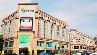
The Verge, formerly Tekka Mall,, was the first and largest modern shopping mall at the Little India precinct in Singapore, being opened in 2003. The Verge had two buildings, the main building and Chill @ The Verge. It was located on the southern part of Little India, with the main building is located at the junction of Serangoon Road and Sungei Road and the Chill @ The Verge is located at the junction of Perak Road and Sungei Road. Both of the buildings were separated by Clive Street and the mall lies opposite of Tekka Centre across Serangoon Road. The complex was demolished in 2017 to make way for redevelopment after 14 years of operation, making it one of the youngest malls in Singapore to shut its doors.

Whampoa is a housing estate located in the subzone of Balestier, which is a part of Novena planning area in Singapore, as defined by the Urban Redevelopment Authority. Within the context of the Housing and Development Board (HDB), however, Whampoa forms part of the Kallang/Whampoa New Town, together with the various housing precincts located in the adjacent Kallang planning area. This makes Kallang/Whampoa the only HDB new town that encompasses two planning areas, namely Novena and Kallang.
My Queenstown Heritage Trail is a walking trail in Queenstown, Singapore. The trail was launched in 2010 by civic group, My Community, to promote the heritage, local culture and architectural styles in Queenstown.
Beauty World Market was an open-air market that was opened in July 1947 in Singapore. It was located at the junction of Upper Bukit Timah Road and Jalan Jurong Kechil. Just next to it was Beauty World Town, another shopping place was opened in 1962. It was located at the junction of Upper Bukit Timah Road and Chun Tin Road. Both shopping areas were completely demolished by 1984 due to frequent fire outbreaks. The original site of the market had since been occupied by two Parking lots and Beauty World MRT Station.

Queenstown Public Library is one of the 26 public libraries established by the National Library Board of Singapore. It was the first full-time Branch Library to be built by the National Library in its plan to decentralise home reading services. It pioneered several firsts amongst Branch Libraries, including becoming the first fully air-conditioned Branch in 1978, computerising its loan services in 1987, and lending video cassettes in 1997. It was refurbished in 2003. The building plans were approved by Mrs Hedwig Anuar, the then-Director of the National Library. Building construction began in November 1968 and with its completion, the building was handed over to the National Library on 26 December 1969. It is currently the oldest library in Singapore after the original National Library at Stamford Road was torn down, the first of 26 under the National Library Board (NLB) to be preserved as announced on 25 July 2014 and was gazetted for conservation under the Urban Redevelopment Authority's Master Plan 2014, as part of the medium-term physical development of Singapore on 6 June that year.

Whampoa Makan Place is a hawker centre and wet market on blocks 90, 91 and 92 along Whampoa Drive in Whampoa, Singapore. The centre is divided into two sections, with one being the hawker centre, and the other being the wet market.

Tanglin Halt is a public housing estate, planning subzone and former industrial estate in Queenstown, Singapore. Most of the older buildings in the estate are set to be demolished by 2024 to make way for redevelopments under the Selective En bloc Redevelopment Scheme. It is the third housing estate to be redeveloped under the scheme.

Orchard Road Market, also known as Tang Leng Pa Sat and Tanglin Pa Sat, was a market on Orchard Road in Singapore. Built in 1891, the market was demolished in 1982 to make way for redevelopments along Orchard Road.

The Vanguard Building, formerly known as the Malaysia Publishing House Building, or simply the MPH Building, is a historic building on the corner of Armenian Street and Stamford Road. It initially housed the Methodist Publishing House. Since 2014, it has been leased to the Singapore Management University.
| | This article about a Singapore building or structure is a stub. You can help Wikipedia by expanding it. |