Commune of Itaba

Last updated
Commune of Itaba
Taba
Itaba
Country Burundi
Province Gitega Province
Administrative center Itaba
Government
  The Administrateur CommunalMs Béatrice NIYONZIMA
Area
   Commune 70 sq mi (170 km2)
Population
   Commune 54,793 inhabitants as per September 2,006
  Density830/sq mi (322/km2)
   Urban
0
Time zone UTC+2 (Central Africa Time)

The commune Itaba is one of 11 municipalities in the province of Gitega, Burundi. It is surrounded in the north by the town of Gitega, to the south by Rutana Province, to the west by the municipalities Bukirasazi and Makebuko, and to the east also by Rutana Province, as well as Ruyigi Province. It covers an area of 170 square kilometres (66 sq mi), equal tp 8.6% of the entire province of Gitega (1,978.96 square kilometres (764.08 sq mi)) and 0.6% of the whole country (27,834 square kilometres (10,747 sq mi)).

Contents

Climate

The climate is tropical, and is moderated by altitude. Under normal conditions, the dry season is from three to four months from June to September. In general, the climate is mild with regular and abundant rainfall. The annual average temperature is 19.7 °C (average maximum 25.5 °C, minimum average 13.8 °C). Generally, temperatures do not experience significant changes in year.

Demographics

The municipality has 54,793 inhabitants living in 10,759 households, with a density average of 322 inhabitants / km2, 27% lower than the density of the Gitega province whose density is 349 inhabitants per km2 on average.

Administrative structure

Zones and administrative divisions

Economy

Agriculture

The Itaba municipality belongs to two natural regions: Kirimiro and Buyogoma. Its soil, its population, its diverse climate and hydrography give it a framework favorable for intensive and varied agriculture. Agriculture covers 90% of the population. It produces food crops, industrial and a little less of vegetable crops and fruit. The production is traditional, with small family farms land (40 acres per household), rudimentary tools, family labor and production mainly for home consumption. Crops are associated that is to say, they practice mixed farming on the same field up to four crops: example: beans, corn, taro, banana. The municipality has three seasons: A: September to February, favorable especially for corn,- B: that is to say, from February to July, with good harvest of beans, and season C in bogs. From May to December: one sows beans, corn, sweet potato. This counts for all the regions in Burundi. Agriculture of the Itaba municipality is based mainly on the work of women. They plow, sow, weed, harvest and transport crops. The men work mainly for some special crops destined for immediate cash-yielding, livestock and making banana beer. Nevertheless, this situation is going to change soon. With the government committed to the mechanization of the agriculture, machinery will replace the traditional hoe leaving a space to modern life-style and market-oriented agricultural production.

Livestock

The Itaba Municipality has a natural environment with abundant natural pastures that can yet be improved. People can also count on the tradition that has seen the municipality of Itaba emerging as one of the most important breeding sites of Burundi throughout the ages. Livestock that has long been seen as a prestigious matter in the municipality of Itaba and in the whole province of Gitega, as it mainly conferred a social status, is now embracing a new era: Zero-grazing, Green-Itaba Municipality, Market-oriented breeding. The livestock is made essentially of: cattle, sheep, goats, pigs and poultry. Traditionally, cows, goats, sheep, were driven to the mountain pastures and valleys for grazing. Very few people made a permanent stall. But as it has been said above, many breeders have now made the politics of zero-grazing theirs, and the results are rather promising: milk production has seen an exponential production that could lead to an implementation of a milk-processing plant in the commune in the foreseeable future.

Food Industry

Education

Schools and universities:

Related Research Articles

<span class="mw-page-title-main">Falcón</span> State of Venezuela

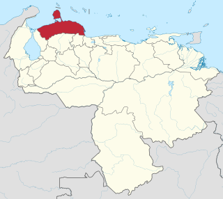
Falcón State is one of the 23 states of Venezuela. The state capital is Coro.

<span class="mw-page-title-main">Navolato, Sinaloa</span> City in the Mexican state of Sinaloa

Navolato is a city in the Mexican state of Sinaloa. It is located in the central coastal part of the state bordering the Gulf of California and serves as the municipal seat for the surrounding municipality of the same name.

<span class="mw-page-title-main">Paraguaçu</span> Municipality in Southeast, Brazil

Paraguaçu is a municipality in the state of Minas Gerais in Brazil. The population is 21,605 in an area of 424 km². The elevation of the municipal seat is 825 m. It became a municipality in 1911.

<span class="mw-page-title-main">Gitega Province</span> Province of Burundi

Gitega is one of the 18 provinces of Burundi. Its capital is Gitega, which is also the national capital. It has a population of 725,223 as of 2008 and an area of 1,979 square kilometres (764 sq mi).

<span class="mw-page-title-main">Viga, Catanduanes</span> Municipality in Catanduanes, Philippines

Viga, officially the Municipality of Viga, is a 4th class municipality in the province of Catanduanes, Philippines. According to the 2020 census, it has a population of 22,869 people.

<span class="mw-page-title-main">Polomolok</span> Municipality in South Cotabato, Philippines

Polomolok, officially the Municipality of Polomolok, is a 1st class municipality in the province of South Cotabato, Philippines. As of May 2020, it has a population of 172,605 people making it the most populated municipality in Mindanao.

<span class="mw-page-title-main">Protección</span> Municipality in Santa Bárbara, Honduras

Protección is a municipality in the Honduran department of Santa Bárbara.

<span class="mw-page-title-main">Luziânia</span> Place in Central-West, Brazil

Luziânia is a municipality in the state of Goiás, Brazil. This city is a producer of agricultural products, including soybeans and beans.

<span class="mw-page-title-main">Ibotirama</span> Municipality in Northeast, Brazil

Ibotirama is a municipality located in the west of the state of Bahia, Brazil. It is in the micro-region of the lower-middle São Francisco River. This major river passes by the city where it is crossed by a recently constructed bridge. Ibotirama covers 1,740.087 km2 (671.851 sq mi), and has a population of 27,003 with a population density of 16 inhabitants per square kilometer. The municipality lies along the São Francisco River, a major inland water route and the fourth-longest river in Brazil.

<span class="mw-page-title-main">Flores de Goiás</span> Municipality in Central-West, Brazil

Flores de Goiás is a municipality in northeastern Goiás state, Brazil.

<span class="mw-page-title-main">Goiandira</span> Municipality in Central-West, Brazil

Goiandira is a municipality in the southeastern portion of the Brazilian state of Goiás. The population was 5,625 (2020) in a total area of 560.7 km2.

<span class="mw-page-title-main">Morrinhos, Goiás</span> Municipality in Central-West, Brazil

Morrinhos is a municipality in southern Goiás state, Brazil. It is a large producer of agricultural products, especially poultry and dairy products.

<span class="mw-page-title-main">Linares Province</span> Province in Maule, Chile

Linares is one of four provinces of the central Chilean region of Maule (VII). The provincial capital and most populous center is the city of Linares.

<span class="mw-page-title-main">Ngozi, Burundi</span> Place in Ngozi Province, Burundi

Ngozi is a town located in northern Burundi. It is the largest urban center in the Ngozi Province and the location of the provincial headquarters.

<span class="mw-page-title-main">Bambuí</span> Municipality in Southeast, Brazil

Bambuí is a Brazilian municipality located in the west of the state of Minas Gerais. Its population as of 2020 was 23,898 people living in a total area of 1,455 square kilometres (562 sq mi), for a density of 15/km2 (39/sq mi). The city belongs to the meso-region of Oeste de Minas and to the micro-region of Piumhi. It became a municipality in 1881.

<span class="mw-page-title-main">Outline of Burundi</span> Country in Central Africa

The following outline is provided as an overview of and topical guide to Burundi:

Messamena is a town and commune in Cameroon.

<span class="mw-page-title-main">Tarqui, Cuenca Canton</span> Rural parish (parroquia) in Cuenca Canton, Azuay, Ecuador

Tarqui is a rural parish (parroquia) in Cuenca Canton, Azuay, Ecuador. Cuenca, officially known as Santa Ana de los Cuatro Ríos de Cuenca, is the capital of the Azuay province located in southern Ecuador. It is made up of 15 urban parishes and 22 rural parishes, including Tarqui. The parish is divided into 26 communities as follows.

<span class="mw-page-title-main">Xochitlán Todos Santos</span> Municipality and town in Puebla, Mexico

Xochitlán Todos Santos (municipality) is one of the 217 town and municipalities of the Mexican state of Puebla. It was founded in 1895.

The commune of Bugabira is a commune of Kirundo Province in northern Burundi. The capital is Bugabira. There are health centers at Muyange and Ruhehe.

References

    3°40′36″S30°00′43″E / 3.67667°S 30.01194°E / -3.67667; 30.01194