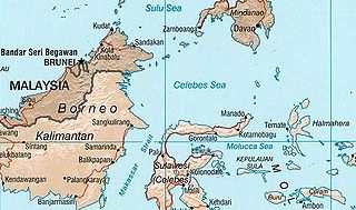
The Celebes Sea or Sulawesi Sea of the western Pacific Ocean is bordered on the north by the Sulu Archipelago and Sulu Sea and Mindanao Island of the Philippines, on the east by the Sangihe Islands chain, on the south by Sulawesi's Minahasa Peninsula, and the west by northern Kalimantan in Indonesia. It extends 420 miles (675 km) north-south by 520 mi (840 km) east-west and has a total surface area of 110,000 square miles (280,000 km2), to a maximum depth of 20,300 feet (6,200 m). South of the Cape Mangkalihat, the sea opens southwest through the Makassar Strait into the Java Sea.

Bubanza is one of the 18 provinces of Burundi.
The Supporters Range is a rugged range in the Queen Maud Mountains of Antarctica. It is 25 nautical miles long, bordering the eastern side of Mill Glacier, from Keltie Glacier in the north to Mill Stream Glacier in the south. So named by the New Zealand Geological Survey Antarctic Expedition (NZGSAE) (1961–62) because several peaks of the range are named after supporters of Ernest Shackleton's British Antarctic Expedition (1907–09).

The Flores Sea covers 240,000 square kilometres (93,000 sq mi) of water in Indonesia. The sea is bounded on the north by the island of Celebes and on the south by the Sunda Islands of Flores and Sumbawa.

Redecilla del Camino is a municipality and town located in the province of Burgos, Castile and León, Spain. According to the 2004 census (INE), the municipality has a population of 148 inhabitants.

Dänischenhagen is an Amt in the district of Rendsburg-Eckernförde, in Schleswig-Holstein, Germany. The seat of the Amt is in Dänischenhagen.
Vishlene is a village in Petrich Municipality, in Blagoevgrad Province, Bulgaria.
Arbanaška is a village in the municipality of Prokuplje, Serbia. According to the 2002 census, the village has a population of 51 people.
North West Cornice is a narrow rock ridge descending in a northwest direction from Big Ben on Heard Island, and terminating at Schmidt Glacier in the northwest part of the island. Surveyed and given this descriptive name by ANARE in 1948. Click here to see a map of North West Cornice and the northwestern coast of Heard Island.

Pajaka is a village in Märjamaa Parish, Rapla County in western Estonia. Pajaka has a population of 48 according to the 2021 census.
Koćura is a village in the municipality of Vranje, Serbia. According to the 2002 census, the village has a population of 234 people. Chetnik Petar Koćura was born in the village.

Noble Glacier is a small glacier lying just north of Flagstaff Glacier on the east side of Keller Peninsula, King George Island, in the South Shetland Islands. Named by the United Kingdom Antarctic Place-Names Committee (UK-APC) in 1960 for Hugh M. Noble of Falkland Islands Dependencies Survey (FIDS), glaciologist at Admiralty Bay in 1957, who made detailed studies of the regime of Flagstaff and Stenhouse Glacier.
Mount Rendu is a mountain between Reid Glacier and Heim Glacier on Arrowsmith Peninsula in Graham Land. Mapped by Falkland Islands Dependencies Survey (FIDS) from surveys and air photos, 1948–59. Named by United Kingdom Antarctic Place-Names Committee (UK-APC) for Louis Rendu (1789–1859), French Bishop and scientist, author of Theorie des glaciers de la Savoie, an important book on the mechanism of glacier flow.

Zvizdar is a village in the municipality of Ub, Serbia. According to the 2011 census, the village has a population of 494 people.
Parthenina interstincta is a rather widely distributed species of sea snail, a marine gastropod mollusk in the family Pyramidellidae, the pyrams and their allies.
Tolon is a small town and is the capital of Tolon District, a district in the Northern Region of north Ghana.

Ouardana is a commune in Bentayeb of the Oriental administrative region of Morocco. At the time of the 2004 census, the commune had a total population of 6921 people living in 1242 households.
This page is based on this
Wikipedia article Text is available under the
CC BY-SA 4.0 license; additional terms may apply.
Images, videos and audio are available under their respective licenses.


