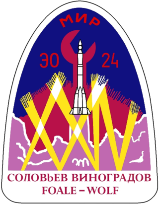
Soyuz TM-26 was a Russian spaceflight that ferried cosmonauts and supplies to Mir. It was the 32nd expedition to Mir. It was launched by a Soyuz-U rocket from Baikonur Cosmodrome on August 5, 1997. The main mission was to transport two specially-trained cosmonauts to repair or salvage the troubled space station.
The Dennistoun Glacier is a glacier, 50 nautical miles long, draining the northern slopes of Mount Black Prince, Mount Royalist and Mount Adam in the Admiralty Mountains of Victoria Land, Antarctica. It flows northwest between the Lyttelton Range and Dunedin Range, turning east on rounding the latter range to enter the sea south of Cape Scott.
The Aviator Glacier is a major valley glacier in Antarctica that is over 60 nautical miles long and 5 nautical miles wide, descending generally southward from the plateau of Victoria Land along the west side of Mountaineer Range, and entering Lady Newnes Bay between Cape Sibbald and Hayes Head where it forms a floating tongue.
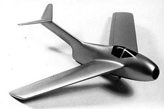
The Focke-Wulf Ta 183 Huckebein was a design for a jet-powered fighter aircraft intended as the successor to the Messerschmitt Me 262 and other day fighters in Luftwaffe service during World War II. It had been developed only to the extent of wind tunnel models when the war ended, but the basic design was further developed postwar in Argentina as the FMA IAe 33 Pulqui II. The name Huckebein is a reference to a trouble-making raven from an illustrated story in 1867 by Wilhelm Busch.

Stonington Island is a rocky island lying 1.8 km (1.1 mi) northeast of Neny Island in the eastern part of Marguerite Bay off the west coast of Graham Land, Antarctica. It is 0.75 km (0.47 mi) long from north-west to south-east and 0.37 km (0.23 mi) wide, yielding an area of 20 ha. It was formerly connected by a drifted snow slope to Northeast Glacier on the mainland. Highest elevation is Anemometer Hill which rises to 25 m (82 ft).
Northeast Glacier is a steep, heavily crevassed glacier, 13 nautical miles long and 5 nautical miles wide at its mouth, which flows from McLeod Hill westward and then south-westwards into Marguerite Bay between the Debenham Islands and Roman Four Promontory, on the west coast of Graham Land, Antarctica.

The Prince Charles Mountains are a major group of mountains in Mac. Robertson Land in Antarctica, including the Athos Range, the Porthos Range, and the Aramis Range. The highest peak is Mount Menzies, with a height of 3,228 m (10,591 ft). Other prominent peaks are Mount Izabelle and Mount Stinear. These mountains, together with other scattered peaks, form an arc about 420 km (260 mi) long, extending from the vicinity of Mount Starlight in the north to Goodspeed Nunataks in the south.
Athos Range is the northernmost range in the Prince Charles Mountains of Mac. Robertson Land, Antarctica. The range consists of many individual mountains and nunataks that trend east–west for 40 miles (64 km) along the north side of Scylla Glacier.

The 2002 Daytona 500, the 44th running of the event, was held on February 17 at Daytona International Speedway in Daytona Beach, Florida as the first of 36 races of the 2002 Winston Cup Season. Rookie Jimmie Johnson, driving the No. 48 Chevrolet for Hendrick Motorsports, won the pole with fellow Daytona 500 rookie Kevin Harvick qualifying second, making this the first time the field would be led by two first-time Daytona 500 participants. Ward Burton, driving the No.22 Dodge for Bill Davis Racing, won the race. This race was the last for long-time veteran driver Dave Marcis.
The Porthos Range is the second range south in the Prince Charles Mountains of Antarctica, extending for about 30 miles in an east-to-west direction between Scylla Glacier and Charybdis Glacier. First visited in December 1956 by the Australian National Antarctic Research Expeditions (ANARE) southern party under W.G. Bewsher (1956-57) and named after Porthos, a character in Alexandre Dumas, père's novel The Three Musketeers, the most popular book read on the southern journey.
Sokorbe is a village and rural commune in Niger. As of 2012, it had a population of 35,579.
The Blaiklock Glacier is a glacier 16 nautical miles (30 km) long, flowing north from Turnpike Bluff, then northwest to Mount Provender and Mount Lowe in the western part of the Shackleton Range, Antarctica.
Eroica Peninsula is an ice-covered peninsula lying north of Beethoven Peninsula and Mendelssohn Inlet in western Alexander Island, Antarctica. The tip of the peninsula is Kosar Point, marking the western extremity of the Eroica Peninsula. It was mapped from trimetrogon air photography taken by the Ronne Antarctic Research Expedition, 1947–48, and from survey by the Falkland Islands Dependencies Survey, 1948–50. It was named by the UK Antarctic Place-Names Committee after Beethoven's Eroica symphony, in association with Beethoven Peninsula. Eroica Peninsula is one of the eight peninsulas of Alexander Island.
Lif Island is a small island of the Tanga Islands of Papua New Guinea, located to the east of New Ireland. It is located to the south-west of Malendok Island and north of Tefa Island. The main settlements are Balamfal and Kitkita.

Dundas was an electoral district of the Legislative Assembly in the Australian state of Victoria from 1856 to 1976. It covered a region of western Victoria and consisted of the counties of Dundas and Follett.

West Bourke was an electoral district of the Legislative Assembly in the Australian state of Victoria from 1856 to 1904.

The Murray was an electoral district of the Legislative Assembly in the Australian colony of Victoria from 1856 to 1877.

