
Sutter's Fort was a 19th-century agricultural and trade colony in the Mexican Alta California province. Established in 1839, the site of the fort was originally called New Helvetia by its builder John Sutter, though construction of the fort proper would not begin until 1841. The fort was the first non-indigenous community in the California Central Valley. The fort is famous for its association with the Donner Party, the California Gold Rush, and the formation of the city of Sacramento, surrounding the fort. It is notable for its proximity to the end of the California Trail and Siskiyou Trails, which it served as a waystation.

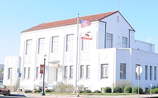
Sutter County is a county located in the U.S. state of California. As of the 2020 census, the population was 99,633. The county seat is Yuba City. Sutter County is included in the Yuba City, CA Metropolitan Statistical Area as well as the Sacramento-Roseville, CA Combined Statistical Area. The county is located along the Sacramento River in the Sacramento Valley.

Yuba County is a county located in north-central Central Valley, California, United States. As of the 2020 U.S. Census, its population was 81,575. Yuba County is included in the Yuba City metropolitan statistical area, which is also included in the Sacramento–Roseville combined statistical area. The county is in the Central Valley region along the Feather River; the county seat is Marysville.
Live Oak is an incorporated city in Sutter County, California, United States. It is part of the Yuba City Metropolitan Statistical Area within the Greater Sacramento CSA, and includes a hamlet historically named Stafford. The population was 9,106 at the 2020 census, up from 8,392 at the 2010 census.

South Yuba City is an unincorporated community and former census-designated place (CDP) in Sutter County, California, United States. It is part of the Yuba City Metropolitan Statistical Area within the Greater Sacramento CSA. The population was 12,651 at the 2000 census.

Yuba City is a city in Northern California and the county seat of Sutter County, California, United States. The population was 70,117 at the 2020 census. Yuba City is the principal city of the Yuba City Metropolitan Statistical Area which encompasses all of Sutter County and Yuba County. The metro area's population is 164,138. It is the 21st largest metropolitan area in California, ranked behind Redding and Chico. Its metropolitan statistical area is part of the Greater Sacramento CSA.
Marysville is a city and the county seat of Yuba County, California, located in the Gold Country region of Northern California. As of the 2010 United States Census, the population was 12,072, reflecting a decrease of 196 from the 12,268 counted in the 2000 Census. It is part of the Yuba-Sutter area of Greater Sacramento.

The Feather River is the principal tributary of the Sacramento River, in the Sacramento Valley of Northern California. The river's main stem is about 73 miles (117 km) long. Its length to its most distant headwater tributary is just over 210 miles (340 km). The main stem Feather River begins in Lake Oroville, where its four long tributary forks join—the South Fork, Middle Fork, North Fork, and West Branch Feather Rivers. These and other tributaries drain part of the northern Sierra Nevada, and the extreme southern Cascades, as well as a small portion of the Sacramento Valley. The total drainage basin is about 6,200 square miles (16,000 km2), with approximately 3,604 square miles (9,330 km2) above Lake Oroville.

The Sutter Buttes are a small circular complex of eroded volcanic lava domes which rise as buttes above the flat plains of the Sacramento Valley in Sutter County, northern California. They are situated just outside Yuba City in the northern part of the state's Central Valley.

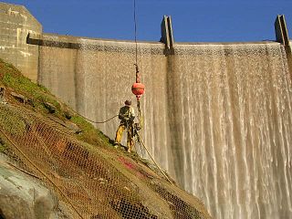
Lake Oroville is a reservoir formed by the Oroville Dam impounding the Feather River, located in Butte County, northern California. The lake is situated 5 miles (8 km) northeast of the city of Oroville, within the Lake Oroville State Recreation Area, in the western foothills of the Sierra Nevada. Known as the second-largest reservoir in California, Lake Oroville is treated as a keystone facility within the California State Water Project by storing water, providing flood control, recreation, freshwater releases to assist in controlling the salinity intrusion into the Sacramento-San Joaquin Delta and protecting fish and wildlife.
Yuba City Charter School is a K-12 public school located in Yuba City, California. Yuba City Charter School is a college prep and CTE program that models and supports the development of good character while emphasizing rigorous academics and career preparation. The school is a student centered direct instruction model, and offers a student success program to help struggling students improve performance, skills, and credit recovery. All students K-6 receive daily formal instruction in music, PE, and Spanish language. Yuba City Charter is fully accredited by the Western Association of Schools and Colleges (WASC). All core high school classes meet the University of California A-G requirements for admission to UC. The student-teacher ratio for K-3 is 20:1 In grades 4-6, classes are capped at 25. In grades 7-12, classes are capped at 28. These caps have been established to ensure small class sizes and to facilitate significantly greater individualized instruction than is available in other schools. Yuba City Charter School also encourages community service and parent participation. YCCS has established a Parent Advisory Committee, and encourages all parents to join. Yuba City Charter School is a public charter school. Enrollment is open to all students without exception. The school is located at 256 Wilbur Ave. in Yuba City, near the Sutter County Fair Grounds. Yuba City Charter School strives for high academic achievement in a small-school atmosphere. YCCS believes that the small school environment paired with individualized instruction and service provides the best educational experience for all students.
California's 1st congressional district is a U.S. congressional district in California. Doug LaMalfa, a Republican, has represented the district since January 2013. Currently, it encompasses the northeastern part of the state. Since the 2022 election, it includes the counties of Butte, Colusa, Glenn, Lassen, Modoc, Shasta, Siskiyou, Sutter, and Tehama, and most of Yuba County. The largest cities in the district are Chico, Redding, and Yuba City.
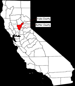
The Yuba–Sutter area, or Yuba City Metropolitan Statistical Area, is a smaller metropolitan community including Yuba and Sutter Counties in Northern California's Central Valley within the Greater Sacramento area.
Yuba College is a public community college in Linda, Yuba County, California. It is part of the Yuba Community College District.
Englebright Dam is a 280 ft (85 m) high variable radius concrete arch dam on the Yuba River in the Sacramento River Basin, located in Yuba and Nevada counties of California, United States. It was put into service in 1941 by the United States Army Corps of Engineers.

KUBA is a radio station based in Marysville, California. which serves the Marysville and Yuba City area, also known as the Yuba–Sutter area. KUBA is simulcast on translator K251CE 98.1 FM. Transmitting power is 5,000 watts day and 2,500 watts night.

Daniel Russell Logue was a Republican assemblyman who represented California's 3rd State Assembly district. He was first elected in November 2008. Prior to serving in the Assembly, Logue served as a Yuba County Supervisor.
Rose's Corral is a former settlement in Nevada County, California, United States. It was located on the lower San Juan Ridge, between Anthony House on Deer Creek and Bridgeport on the South Yuba River. The merchant John Rose built it close to a trading post he had erected near where Pleasant Valley Road meets Del Mar Way. Established during the summer of 1848, it is notable for being the county's first settlement. It is named for a cattle corral built by John Rose, a trader.
Rancho Johnson was a 22,197-acre (89.83 km2) Mexican land grant in present-day Yuba County, California, given in 1844 by Governor Manuel Micheltorena to Pablo Gutiérrez. The grant was located along the north side of Bear River, and encompassed present-day Wheatland.
Rancho Honcut was a 31,080-acre (125.8 km2) Mexican land grant in present day Yuba County, California given in 1844 by Governor Manuel Micheltorena to Theodor Cordua. The rancho is named after Honcut Creek which bounded the grant on the north. The grant was bounded on the east by the Sierra Nevada Mountains, on the south by the Yuba River, on the west by the Feather River, and included present day Honcut and Ramirez.
