Community of Arran Seabed Trust

Last updated

COAST logo COAST logo.jpg
COAST logo

The Community of Arran Seabed Trust (COAST) is a registered Scottish charity based on the Isle of Arran, the largest island in the Firth of Clyde. [1] Established in 1995 by two local divers (Howard Wood and Don McNeish) COAST has been a registered charity since 2011 and is run mostly by Arran residents, who all share the same aims to protect the health of the marine environment around the Isle of Arran and within the Firth of Clyde from indiscriminate commercial fishing methods. [2] COAST values the marine biodiversity around the shoreline of Arran and aims to regenerate and protect it for future generations.

Contents

COAST was the driving force behind the creation of Scotland's first No Take Zone (NTZ) in Lamlash Bay in 2008. In May 2012 COAST submitted a proposal for a Marine Protected Area (MPA) around the south of Arran which, now that the MPA has been designated, is part of the Scottish MPA network. The South Arran MPA is one of the very few Scottish MPA's which has been motivated and developed by the local community.

Vision and purpose

COAST's vision is for healthy seas around Arran and in the Clyde. The purpose is to ensure shared responsibility for the protection and restoration of the marine environment and the diversity of life it supports in this area. [3]

Main objectives

COAST's charitable objectives are:

  1. To identify and secure, areas of seabed around the Isle of Arran for the community to promote and protect all forms of marine life;
  2. To protect and improve the surrounding waters adjacent to the project for the advancement of environmental protection to promote sustainable marine stocks;
  3. To educate the community, individuals and organisations in relation to the need for marine conservation.

Strategy

COAST will work collaboratively to research the social, economic and environmental benefits of restoring and protecting Clyde seas, to promote widespread awareness of the findings and actively campaign for the protection and restoration of this public resource.

Research

COAST is conducting long-term research and monitoring programmes in Arran's waters. It is an active participant in the Seasearch initiative and also hosts and supports researchers from the University of Glasgow, University of York, Edinburgh Napier University and Herriot Watt University. The impacts of the No Take Zone (NTZ) are monitored annually to obtain data on the development of species such as scallops and crustaceans and the regeneration of the seabed within and outside of the protected area. Marine research underpins the South Arran MPA proposal and baseline studies were carried out prior to designation in July 2014 and have continued since, both by academic research institutes and government agencies.

Additional aims

Funders

COAST is currently funded mainly by grants from Esmée Fairbairn Foundation and the John Ellerman Foundation and has previously received support from The Underwood Trust Scottish Natural Heritage, European Commission Directorate General for the Environment, Marine Conservation Society and initial start-up funding from the Lottery Awards for All.

History of the Firth of Clyde ecosystem and the need for conservation measures

The Firth of Clyde in South West Scotland, an area of 3650 square miles, is the most southerly fjord in the northern hemisphere and extends over 100 km into Scotland's west coast. Once comprising a highly diverse and rich ecosystem the Firth of Clyde marine environment has seen dramatic alterations throughout the last 200 years. [4] During the 19th century, diverse mixed fisheries existed in the Firth of Clyde for herring (Clupea harengus), cod (Gadus morhua), haddock (Melanogrammus aeglefinus), turbot (Psetta maxima) and a variety of other species. [4] [5]

The 19th century saw increased demand for fish, which encouraged more indiscriminate methods of fishing such as bottom trawling to also catch demersal fish (fish living and feeding mainly on the seabed). During the 1880s, fish landings began to decline, and upon the recommendation of local fishers and scientists, the Firth of Clyde was closed to large trawling vessels in 1889. This closure remained in place until 1962 when bottom trawling for Norway lobster (Nephrops norvegicus) was approved in areas more than three nautical miles (nm) from the coast. During the 1960s and 1970s, landings of bottomfish increased as trawling intensified. The trawl closure within three nm of the coast was repealed in 1984 under pressure from the industry. Thereafter, bottomfish landings went into terminal decline, with all species collapsing to zero or near zero landings by the early 21st century. Herring fisheries collapsed in the 1970s as more efficient mid-water trawls and fish finders were introduced.

Between the 1960s and the early 2000s populations of cod and haddock have dropped by 95 - 99%. [5] A population is termed 'collapsed' if there is a decline of over 90% from the peak catch. This collapse of commercial populations in the Clyde is often compared to the similar collapse of cod fishing in Newfoundland in the 1990s due to intense overfishing. [5] Today there is now no viable fishery of those species. Instead invertebrate species are targeted, such as the Norway lobster and scallops (Pecten maximus). For this usually otter trawls and dredges are used, which are dragged along the seabed to disturb bottom-dwelling fish, a practice which damages seabed habitats. [4] [5]

In July 2011, a paper was published indicating a major ecological impact of fishing on the ecosystems of the Clyde. Fishing is thought to have completely altered the mix and size distribution of fish species in the Clyde. Once dominated by large predatory species (e.g. spurdog, hake and cod), now 70% of species found are small whiting and other small fish. [6] Such a simplification of the ecosystem can possibly lead to a decline in diversity, thus threatening fish stocks and fishery of the future. [7] A report by Marine Scotland suggests that these changes might have been, amongst others, caused by high by-catch rates found in Nephrops fisheries using trawling and dredging equipment. [4] The habitat destruction caused by these methods is also thought to be a major factor influencing species composition and size. [5] Other scientists have concluded that the marine ecosystems in the Clyde are nearing the endpoint of overfishing [5] but, as the Clyde used to be a highly productive system, there is potential for recovery if appropriate measures are taken. [4]

In partnership with a wide range of stakeholders, the Scottish Government announced the Clyde 2020 initiative, which will involve research and practical measures to improve the Firth of Clyde marine ecosystem. In April 2014, the Clyde summit was held, where a wide range of stakeholders were brought together to determine the focus of and develop an action plan for the initiative. [8]

No Take Zone

View of the No Take Zone in Lamlash Bay and information board View of NTZ.JPG
View of the No Take Zone in Lamlash Bay and information board

Scotland's first No Take Zone (NTZ) was designated by the Scottish Government on 20 September 2008 at the north end of Lamlash Bay on the east of the Isle of Arran, after 13 years of campaigning by COAST. It was established to protect Maerl beds and to promote natural regeneration of all marine life. It covers an area of 2.67 km2 of sea and seabed from which no marine life can be removed by any method. This was achieved after over a decade of campaigning by the island community. [1]

Benefits of a NTZ

No take zones are likely to economically benefit fisheries, tourism and local communities, and have done so in many areas of the world. [9] By protecting a certain area from external disturbances such as damaging fishing methods, biomass and diversity can flourish and improve within a short time. Nearby fisheries and ecosystem can benefit from enhanced recruitment within the protected area when individuals leave the protected zone ('spillover effect'). Long term, the establishment of a network of protected zones can create optimal harvesting areas. [10] The UK's first NTZ around Lundy Island in the Bristol Channel, Devon, established in 2003 is an example for the beneficial effects of a protected marine area. Five years after its creation, scientific surveys of the NTZ's ecology have found an increase in abundance and average size of landable-sized lobsters, both within and adjacent to the protected area; as well as an increase in numbers of undersized lobsters within the NTZ's boundary. Additionally the local tourism sector recorded an increase of divers, anglers and sightseers thanks to increased publicity surrounding Lundy and the marine reserve as a result of its designation, and the resulting improvement of marine biodiversity, including seabirds. [11]

A study conducted by researchers from the University of York in 2013, provides evidence that the creation of the NTZ in Lamlash bay has supported the regeneration of the seabed and overall biodiversity of the area. Animals which attach to the seabed, such as maerl and hydrozoans were found to be twice as abundant inside the NTZ than outside. In addition, within the NTZ, the average size of scallops and lobsters were larger. Scallops were more abundant, larger and older within the NTZ, while higher numbers of larger lobsters were found inside the NTZ, which is thought to increase their reproductive potential. [12] The majority of species found across all habitats in the NTZ were all bottom dwelling, opportunistic invertebrates (such as crabs and starfish), which suggests there is still some recovery to go.

Maerl

Maerl, a corraline algae ARRAN SEASCENES 013.jpg
Maerl, a corraline algae

A significant marine feature in the Lamlash bay NTZ are the Maerl beds. Maerl is also present in the South Arran MPA. Maerl is a very slow-growing (1 mm per year) coral-like calcareous red algae and is an important Scottish species. [13] Maerl beds are reservoirs of biodiversity, important both as nursery grounds for young scallops and young fish. Studies show that organic waste from fish farms significantly reduces live maerl and that scallop dredging has profound and long lasting impacts. Scallop dredging on a maerl bed has been found to kill over 70% of live maerl, with no discernible recovery over the following four years. Recovery of maerl beds would be expected to require many years without disturbance. [14]

Scotland's Marine Protected Area Network

Marine Protected Areas (MPAs) are geographically defined marine zones, used as a management tool used to protect the marine environment. MPAs are recognised as a specific means to achieve 'good environmental status' in the marine environment. In 2011 Scottish Natural Heritage (SNH) proposed a network of 33 MPAs for designation to the Scottish government. As of July 2014, 30 MPAs were designated; 17 of which are in Scotlands inshore zone (within 12 nm), and 13 are offshore. [15]

The United Kingdom has a duty to create an ecologically coherent network of marine protected areas by 2012, as promised under several agreements including the OSPAR Convention, World Summit on Sustainable Development, Convention on Biological Diversity, [16] Water Framework Directive and most recently the Marine Strategy Framework Directive (MSFD). The European MSFD was transposed into UK legislation on 15 July 2010 and requires member states to prepare national strategies to manage their seas to achieve or maintain Good Environmental Status by 2020. [17] In Annex I, 11 qualitative descriptors were set up to determine 'good environmental status'. Amongst others, they require the maintenance of biological diversity (descriptor 1), populations of all commercially exploited fish and shellfish to be within safe biological limits exhibiting a population age and size distribution that is indicative of a healthy stock (descriptor 3) and to ensure that sea-floor integrity is at a level that ensures that the structure and functions of the ecosystems are safeguarded and benthic ecosystems, in particular, are not adversely affected (descriptor 6).

The Marine and Coastal Access Act 2009 provides executive devolution to Scottish Ministers of the new marine planning and conservation powers in the offshore region (12-200 nautical miles) of Scotland and in particular, the power to designate MPAs. This will provide greater flexibility for Ministers to use area-based measures to conserve marine biodiversity. [18] Marine Protected Areas are essential for healthy, functioning and resilient ecosystems which help to deliver the Government's vision of a clean, healthy, safe, productive and biologically diverse oceans and seas. As some human activities can damage or cause disturbance to marine habitats and their species, a MPA is designed to manage or restrict such activities.

Case studies from Scottish waters support the general scientific consensus that use of mobile fishing gear, particularly bottom-trawls and dredges, is the most pervasive form of human disturbance to the seabed environment and the most significant cause of ecosystem degradation in coastal seas. Other processes, such as discharge of organic waste and water-borne chemical contaminants can be locally important, but are of much lower overall impact than the use of mobile fishing gear. [14]

South Arran MPA

In 2012 COAST submitted their proposal to Scottish Natural Heritage (SNH) for a designated Marine Protected Area (MPA) around the South of Arran under the Marine Scotland Act 2010. On 24 July 2014 the South Arran MPA was created. Though management measures are still to be determined, COAST is advocating all active/towed gear (trawls, dredged and hydraulic methods) should be excluded from the entire proposed South Arran MPA. This will allow regeneration of the seabed and increase the social and economic benefit to the Clyde. COAST recommends that only sustainable methods such as creeling, hand diving for scallops and angling should be allowed inside the MPA. Currently, the management for the South Arran MPA has not been designated and all activities in the area are continuing as normal. Marine Scotland has proposed options which allow for the continuation of trawling and dredging in the MPA. [19]

The South of Arran MPA will:

The MPA will not:

Related Research Articles

Firth of Clyde Inlet on the west coast of Scotland

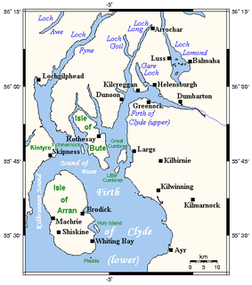
The Firth of Clyde is the mouth of the River Clyde. It is located on the west coast of Scotland and constitutes the deepest coastal waters in the British Isles. The firth is sheltered from the Atlantic Ocean by the Kintyre peninsula, which encloses the outer firth in Argyll and Ayrshire. The Kilbrannan Sound is a large arm of the Firth of Clyde, separating the Kintyre Peninsula from the Isle of Arran. Within the Firth of Clyde is another major island – the Isle of Bute. Given its strategic location at the entrance to the middle and upper Clyde, Bute played a vital naval military role during World War II.

Lamlash Town in Scotland

Lamlash is a village on the Isle of Arran, in the Firth of Clyde, Scotland. It lies three miles south of the island's main settlement and ferry port Brodick, in a sheltered bay on the island's east coast, facing the Holy Isle. Lamlash is the seat of Arran's local government offices, and is also the location of the island's only police station, secondary school and hospital. In common with the rest of the island, the village's main industry is tourism and the public sector is also an important employer. Lamlash has an RNLI Lifeboat station with a B class Atlantic 75 lifeboat, covering the inshore waters around the coast of Arran, and in summer, there is a regular ferry service from Lamlash harbour to Holy Isle. The village has several buildings of historical interest, including Hamilton Terrace, which consists of two rows of idyllic single storey-and-attic cottages on the Lamlash seafront, arranged in pairs.

Bottom trawling Fishing method for fishing trawlers

Bottom trawling is trawling along the seafloor. It is also referred to as "dragging". The scientific community divides bottom trawling into benthic trawling and demersal trawling. Benthic trawling is towing a net at the very bottom of the ocean and demersal trawling is towing a net just above the benthic zone. Bottom trawling can be contrasted with midwater trawling, where a net is towed higher in the water column. Midwater trawling catches pelagic fish such as anchovies and mackerel, whereas bottom trawling targets both bottom-living fish (groundfish) and semi-pelagic species such as cod, squid, shrimp, and rockfish.

Firth of Lorn Body of water

The Firth of Lorn or Lorne is the inlet of the sea between the south-east coast of the Isle of Mull and the mainland of Scotland. It includes a number of islands, and is noted for the variety of wildlife habitats that are found. In 2005, a large part of the Firth became a Special Area of Conservation.

Fishing industry in Scotland Aquaculture and marine catching in the UK countrt

The fishing industry in Scotland comprises a significant proportion of the United Kingdom fishing industry. A recent inquiry by the Royal Society of Edinburgh found fishing to be of much greater social, economic and cultural importance to Scotland than it is relative to the rest of the UK. Scotland has just 8.4 per cent of the UK population but lands at its ports over 60 per cent of the total catch in the UK.

Fishing dredge

A fishing dredge, also known as a scallop dredge or oyster dredge, is a kind of dredge which is towed along the bottom of the sea by a fishing boat in order to collect a targeted edible bottom-dwelling species. The gear is used to fish for scallops, oysters and other species of clams, crabs, and sea cucumber. The dredge is then winched up into the boat and emptied. Dredges are also used in connection with the work of the naturalist in marine biology, notably on the Challenger Expedition.

Fishing in the North Sea

Fishing in the North Sea is concentrated in the southern part of the coastal waters. The main method of fishing is trawling.

This page is a list of fishing topics.

The following outline is provided as an overview of and topical guide to fishing:

This is a glossary of terms used in fisheries, fisheries management and fisheries science.

Fishing industry in the United States

As with other countries, the 200 nautical miles (370 km) exclusive economic zone (EEZ) off the coast of the United States gives its fishing industry special fishing rights. It covers 11.4 million square kilometres, which is the second largest zone in the world, exceeding the land area of the United States.

The North Pacific Fishery Management Council (NPFMC) is one of eight regional councils established by the Magnuson–Stevens Fishery Conservation and Management Act in 1976 to manage the fisheries of the United States. With jurisdiction over the 900,000-square-mile (2,300,000 km2) Exclusive Economic Zone (EEZ) off Alaska, the Council has primary responsibility for groundfish management in the Gulf of Alaska, Bering Sea and Aleutian Islands, including cod, pollock, flatfish, mackerel, sablefish, and rockfish species. Other large Alaska fisheries such as salmon, crab and herring are managed primarily by the State of Alaska.

Gulf of Maine Closed Areas

The Gulf of Maine has been fished since the 1700s, and has been a historic fishing area since. Climate change is having significant impacts on this ecosystem; between 2004 and 2013, the Gulf of Maine has warmed faster than 99.9% of the global oceans, increasing average temperature by 2 °C (3.6 °F). Having seen the depletion of groundfish stocks starting in the early 1990s, managers took care to create five closure areas in the Gulf of Maine.

Howard Wood OBE is a Scottish environmentalist, co-funder of Community of Arran Seabed Trust (COAST) and Goldman Environmental Prize winner in 2015.

The marine protected areas of South Africa are in an area of coastline or ocean within the exclusive economic zone (EEZ) of the Republic of South Africa that is protected in terms of specific legislation for the benefit of the environment and the people who live in and use it. An MPA is a place where marine life can thrive under less pressure than unprotected areas. They are like underwater parks, and this healthy environment can benefit neighbouring areas.

Marine Protected Areas in Scotland

In Scotland, Marine Protected Areas (MPAs) are areas of sea defined so as to protect to habitats, wildlife, geology, undersea landforms, historic shipwrecks, and to demonstrate sustainable management of the sea. As of December 2020, approximately 37% of Scotland's seas are covered by the Scottish MPA network, which comprises 244 sites in total.

Loch Sunart to the Sound of Jura Marine Protected Area Protected area of sea off Scotland

Loch Sunart to the Sound of Jura Marine Protected Area is a Marine Protected Area (MPA) off the west coast of Scotland. The MPA, which covers 741 km2 (286 sq mi), includes the waters of Loch Sunart, the Sound of Mull, the Firth of Lorne and the Sound of Jura. It has been designated to protect the population of common skate and the area's quaternary geological features. The MPA is designated a Category IV protected area by the International Union for Conservation of Nature.

Marine conservation zones in Yorkshire List of Marine Conservation Zones in Yorkshire

The marine conservation zones in Yorkshire, were created in 2016 and 2019 after an extensive consultation, which drew criticism of the UK Government's plans which designated only 31 zones out of the projected 127 zones in 2013. An £8 million study recommended the 127 sites, of which, eight lay in and around the coast of Yorkshire.

Laxey Bay is a coastal feature and Marine Nature Reserve on the east coast of the Isle of Man in the north Irish Sea. Geographically it is bounded by Laxey Head to the north and Clay Head to the south.

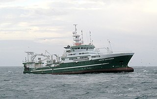
The fishing vessel Antares was a pelagic trawler based in Carradale, Kintyre in the United Kingdom. She was fishing off the coast of the Isle of Arran on 22 November 1990 when she foundered with the loss of four crew members after her trawl line was snagged by Royal Navy Trafalgar class nuclear powered submarine HMS Trenchant. An investigation by the Marine Accident Investigation Branch concluded that the accident had been caused by "a partial breakdown in both the structure and the standards of watchkeeping on board Trenchant".

References

  1. 1 2 ArranCOAST
  2. BBC News - Marine life 'flourishing' at Lamlash reserve
  3. AlJazeera Arran No Take Zone
  4. 1 2 3 4 5 McIntyre F, Fernandes PG and Turrell WR (2012) Clyde Ecosystem Review. Scottish Marine and Freshwater Science Vol 3 No 3
  5. 1 2 3 4 5 6 Thurstan RH, Roberts CM (2010) Ecological Meltdown in the Firth of Clyde, Scotland: Two Centuries of Change in a Coastal Marine Ecosystem. PLOS One 5(7): e11767. doi:10.1371/journal.pone.0011767
  6. Heath MR and Speirs DC (2011) Changes in species diversity and size composition in the Firth of Clyde demersal fish community (1927–2009) Proc. R. Soc. Vol. 279 no. 1728 543-552
  7. Howard LM, Roberts CM, Thurstan RH, Stewart BD (2013) The unintended consequences of simplifying the sea: making the case for complexity. Fish and Fisheries, DOI: 10.1111/faf.12041
  8. "Clyde 2020". Archived from the original on 18 July 2014.
  9. Roberts CM, Bohnsack JA, Gell F, Hawkins JP, Goodridge R (2001) Effects of Marine Reserves on Adjacent Fisheries. Science Vol 294, 1920 - 1923
  10. Grafton RQ, Komas P, Van Ha P (2006) The Economic Payoffs from Marine Reserves: Resource Rents in a Stochastic Environment*. The Economic Record Vol. 82, No. 259, pp. 469–480
  11. IUCN, 2009. Marine protected areas case studies, Lundy Island NTZ
  12. http://www.arrancoast.com/pdf2013/Summary_of_York_University_research_within_Lamlash_Bay_No_Take_Zone_2013.pdf Archived 23 January 2015 at the Wayback Machine >
  13. "Maerl - Scottish Natural Heritage". Archived from the original on 3 February 2015. Retrieved 3 February 2015.
  14. 1 2 Hughes D & Nickell T (2009) Recovering Scotland’s Marine Environment, Report to Scottish Environment LINK
  15. "Marine environment: Marine Protected Areas (MPAs) - gov.scot".
  16. "About Marine Protected Areas | JNCC - Adviser to Government on Nature Conservation".
  17. Marine Strategy Framework Directive
  18. Marine and Coastal Access Act 2009
  19. "South Arran Marine Protected Area: A baseline study., Stark J". 16 October 2015.