
Stanislaus County is a county located in the San Joaquin Valley of the U.S. state of California. As of 2023, its estimated population is 564,404. The county seat is Modesto.

Modesto is the county seat and largest city of Stanislaus County, California, United States. With a population of 218,069 according to 2022 U.S. Census Bureau estimates, it is the 19th largest city in the State of California.
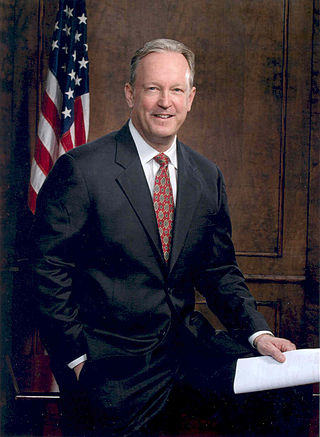
George Purdy Radanovich is an American politician and former U.S. Representative for California's 19th congressional district, serving from 1995 to 2011. The district includes most of northern Fresno, as well as several rural areas northeast of the city. He did not seek reelection in 2010. He is a member of the Republican Party.

Interstate 205 (I-205) is an east–west auxiliary Interstate Highway in the San Joaquin Valley in Northern California. It runs from I-5 west to I-580. Along with those highways, I-205 forms the north side of a triangle around the city of Tracy. The route provides access from the San Francisco Bay Area to the northern San Joaquin Valley.
KUVS-DT is a television station licensed to Modesto, California, United States, broadcasting the Spanish-language Univision network to the Sacramento area. It is owned and operated by TelevisaUnivision alongside Stockton-licensed UniMás outlet KTFK-DT. The two stations share studios on Arden Way near Cal Expo in Sacramento; KUVS-DT's transmitter is located near Valley Springs, California.
KSTV-LD is a low-power television station in Sacramento, California, United States, affiliated with LATV. The station is owned by Lazer Broadcasting, the company's only television station.

KJSN is a commercial radio station in Modesto, California, known as "Sunny 102.3." It is owned by iHeartMedia, Inc., and broadcasts an adult contemporary radio format, switching to Christmas music for much of November and December. The radio studios are on Lancey Drive in Modesto. The transmitter is on Fine Avenue near Floyd Avenue in Modesto.
KMPH is a radio station licensed to and serving the Modesto, California area. The station is owned by Relevant Radio, Inc.
This Morning: America's First News is a two-hour radio news/talk program hosted by Gordon Deal and Jennifer Kushinka, who replaced long-serving co-host Gina Cervetti on January 2, 2015. In addition to national and world headlines, the program covers a broad range of topics such as business, finance, lifestyle, careers, technology, and more. This Morning is broadcast on over 250 radio stations across the United States in early-morning drive time. Segments are repackaged into a weekend review show and podcast. Deal began hosting the program in November 2005, following the departure of Michael Wallace, who hosted the program for two years. Until January 2015, the program was produced by the Wall Street Journal Radio Network, which the Wall Street Journal shut down on December 31, 2014 due to corporate cutbacks.

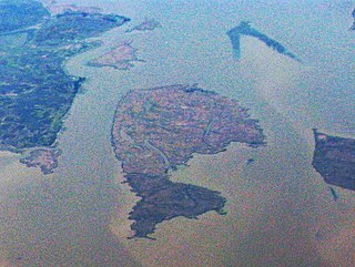
Woodward Island is an island in the Sacramento-San Joaquin River Delta, twenty kilometres east of Antioch, and twenty kilometres west of Stockton. The 725 ha (1,790-acre) island is bounded on the west by Old River, on the north by Bacon Island, on the east by Middle River, and Woodward Canal on the south. It is in San Joaquin County, and managed by Reclamation District 2072. It appears on 1913 and 1952 United States Geological Survey maps of the area.
Empire Union School District is a school district based in Modesto, California, United States.
Chester Smith was an American country-western musician and business entrepreneur.
The 1928 Fresno State Bulldogs football team represented Fresno State Normal School—now known as California State University, Fresno—during the 1928 college football season.
Snag Island is a small island in Suisun Bay, California. It is part of Solano County. Its coordinates are 38°04′22″N121°58′23″W.
West Island is a small island in the San Joaquin River, California. It is part of Sacramento County. Its coordinates are 38°01′24″N121°46′43″W. It is shown, labeled "Webers Island", on an 1850 survey map of the San Francisco Bay area made by Cadwalader Ringgold and an 1854 map of the area by Henry Lange.

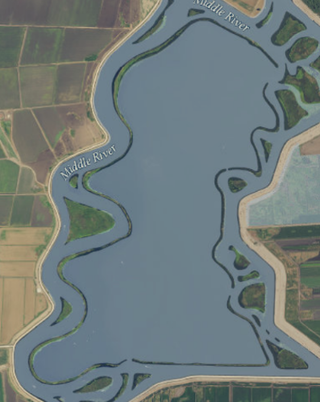
Fay Island is a small, partially submerged island in the San Joaquin River delta, in California. It is part of San Joaquin County, and managed by Reclamation District 2113. Its coordinates are 37.9485348°N 121.5652291°W. It appears, almost completely submerged, on a 1952 United States Geological Survey map of the area.
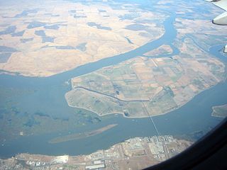
Mildred Island is a submerged island in the San Joaquin River delta, in California. It is part of San Joaquin County. It flooded in 1983, and the land was abandoned. Its coordinates are 37.9863117°N 121.5230069°W. It appears on 1913 and 1952 United States Geological Survey maps of the area.

The Rio Blanco Tract is an island in the Sacramento–San Joaquin River Delta. It is part of San Joaquin County, California, and managed by Reclamation District 2114. Its coordinates are 38°04′46″N121°24′18″W, and the United States Geological Survey measured its elevation as 0 ft (0 m) in 1981. It appears on a 1952 USGS map of the area.

The Shima Tract is an island in the Sacramento–San Joaquin River Delta. It is part of San Joaquin County, California, and managed by Reclamation District 2115. Its coordinates are 38°01′40″N121°23′06″W, and the United States Geological Survey measured its elevation as 0 ft (0 m) in 1981. It appears on a 1952 USGS map of the area.

The Shin Kee Tract is an island in the Sacramento–San Joaquin River Delta. It is part of San Joaquin County, California, and not managed by any reclamation district. Its coordinates are 38°05′45″N121°25′09″W, and the United States Geological Survey measured its elevation as 0 ft (0 m) in 1981. It appears on a 1952 USGS map of the area.