Cóndor Tuco or Condortuco is a mountain in the Vilcanota mountain range in the Andes of Peru, about 5,550 metres (18,209 ft) high. It is situated in the Cusco Region, Canchis Province, Pitumarca District. Cóndor Tuco lies between the Chillcamayu in the west and the lake named Sibinacocha in the east, south of Jatunhuma, Huayruro Punco and Comercocha.

Ccerayoc is a 5,092-metre-high (16,706 ft) mountain in the Urubamba mountain range in the Andes of Peru. It is located in the Cusco Region, Calca Province, in the districts Calca and Lares. It lies immediately east of Sahuasiray and northeast of Condorhuachana.

Araway Qhata which further to the south is named Kunturuma is a mountain in the south of the city of Cusco in Peru. It lies in the Cusco Region, Cusco Province, Santiago District. The words Viva El Perú Glorioso have been carved into the mountain side in large letters so that they can be read from the city below.

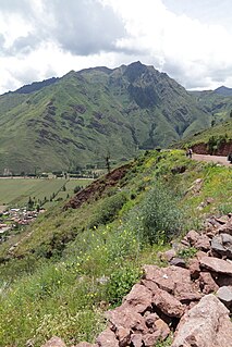
Inti Watana or Intiwatana (Quechua) is an archaeological site in Peru. It lies in the Cusco Region, Calca Province, Pisac District.

Parorjo is a mountain in the Urubamba mountain range in the Andes of Peru. It is situated in the Cusco Region, Calca Province, Lares District. Its summit is 4,891 m (16,047 ft) high. Parorjo is situated at the Lares trek north of Chicón and Sirihuani and west of Pucaorjo. One of the nearest populated places is Quishuarani. There is a small lake at its feet named Parococha.

Kuntur Sinqa is a mountain in the Cusco Region in Peru, about 4,256.8 metres (13,966 ft) high. It lies in the Paruro Province, Pillpinto District. Kuntur Sinqa is situated west of the Apurímac River.

Machu Kuntur Sinqa or Machu Kuntur Sankha is a mountain in the Cusco Region in Peru, about 4,200 metres (13,780 ft) high. It is situated in the Calca Province, on the border of the districts Pisac and San Salvador. Machu Kuntur Sinqa lies on the right bank of the Willkanuta River, near the archaeological park of Pisac.

Kuntur Wachanan is a mountain in the Andes of Peru, about 4,800 m (15,700 ft) high. It lies between the Waywash mountain range in the west and the lake named Lawriqucha in the east. Kuntur Wachanan is situated in the Huánuco Region, Lauricocha Province, in the districts of Cauri and Jesús. The Waywash River (Huayhuash) flows along its northern slopes. It belongs to the Marañón watershed.

Huamanchoque is a 5,156-metre-high (16,916 ft) mountain in the Urubamba mountain range in the Andes of Peru. It is located in the Cusco Region, Calca Province, Calca District, north of the Vilcanota River. Huamanchoque lies at the Cancha Cancha valley where the Lares trek route passes by. It is situated south of Canchacanchajasa, southwest of Sahuasiray and Cóndorhuachana, and north of a lower peak named Cóndorhuachana. One of the nearest towns is Huayllabamba.

Canchacanchajasa is a 4,987-metre-high (16,362 ft) mountain in the Urubamba mountain range in the Andes of Peru. It is located in the Cusco Region, Calca Province, Calca District, north of the Urubamba River. Canchacanchajasa is situated southeast of Sirihuani, north of Cóndorhuachana and Huamanchoque and southwest of Sahuasiray. It lies in the upper part of the Cancha Cancha valley (kancha kancha) at the Lares trek.

Ichhunayuq is a mountain in the Andes of Peru, about 4,200 metres (13,780 ft) high. It is located in the Cusco Region, Calca Province, on the border of the districts of Coya and Pisac. Ichhunayuq lies at the archaeological site of Písac, northwest of the town.

Ancasmarca, also known as Pitusiray or Sallcasa, is a 5,198-metre-high (17,054 ft) mountain in the Urubamba mountain range in the Andes of Peru. It is located in the Cusco Region, Calca Province, Calca District, north of the Vilcanota River. Ancasmarca is situated northeast of Huamanchoque, southeast of Canchacanchajasa, south of Sahuasiray, and southwest of Ccerayoc and Condorhuachana.

Kuntur Wamani is a mountain in the Chunta mountain range in the Andes of Peru, about 4,800 metres (15,748 ft) high. It is located in the Huancavelica Region, Castrovirreyna Province, Santa Ana District, and in the Huancavelica Province, Huancavelica District. Kuntur Wamani lies southeast of Wamanrasu, northwest of Qarwarasu and northeast of Antarasu.

Kuntur Wamani is a mountain in the Chunta mountain range in the Andes of Peru, about 4,800 metres (15,748 ft) high. It is situated in the Huancavelica Region, Castrovirreyna Province, Santa Ana District. Kuntur Wamani lies southwest of Qarwarasu.

Kuntur K'uchu is a mountain in the Wansu mountain range in the Andes of Peru, about 5,200 metres (17,060 ft) high. It is situated in the Arequipa Region, La Unión Province, Puyca District, and in the Cusco Region, Chumbivilcas Province, Santo Tomás District. It lies northwest of Qullpa and north of Pichaqani.

Coscojahuarina is a mountain in the eastern extensions of the Urubamba mountain range in the Andes of Peru, about 4,600 m (15,100 ft) high. It is located in the Cusco Region, Calca Province, Calca District. It lies southeast of Huamanchoque and Pitusiray.

Maquimaquiyoc is a mountain in the eastern extensions of the Urubamba mountain range in the Andes of Peru, about 4,200 m (13,800 ft) high. It is located in the Cusco Region, Calca Province, Calca District. It lies east of Coscojahuarina and southeast of Huamanchoque and Pitusiray.

Coscojahuarina is a 4,623-metre-high (15,167 ft) mountain in the eastern extensions of the Urubamba mountain range in the Andes of Peru It is located in the Cusco Region, Calca Province, Calca District. It lies south of Llamayojcasa and west of the village of Totora.

Kuntur Salla is a 5,003-metre-high (16,414 ft) mountain in the Andes of Peru. It is located in the Arequipa Region, Condesuyos Province, Cayarani District.

Kuntur Wachana is a 3,396-metre-high (11,142 ft) mountain in the Bolivian Andes. It is located in the Cochabamba Department, Capinota Province, Sicaya Municipality.


