Sahuasiray

Last updated
Sahuasiray
Ccolque Cruz
Peru - Lares Trek 016 - gprgeous glaciers spill down the high peaks (7584247754).jpg
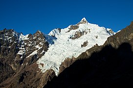
The snow-covered Sahuasiray.
Highest point
Elevation 5,818 m (19,088 ft)
Prominence 1,920 m (6,300 ft) [1]
Listing Ultra
Coordinates 13°12′50″S71°59′18″W / 13.21389°S 71.98833°W / -13.21389; -71.98833
Geography
Peru physical map.svg
Red triangle with thick white border.svg
Sahuasiray
Peru
Location Cusco, Peru
Parent range Urubamba, Andes
Climbing
First ascent Sahuasiray N: 1-1963 via E. ridge. Sahuasiray S: 1-1968 [2]

Sahuasiray [1] [2] [3] [4] [5] (possibly from Quechua sawa matrimony, siray to sew, [6] ), Sawasiray, [7] Colque Cruz [1] or Ccolque Cruz [8] (possibly from Aymara and Quechua qullqi silver, money, Spanish cruz cross, "silver cross")[ citation needed ], is one of the highest mountains in the Urubamba mountain range in the Andes of Peru, about 5,818 metres (19,088 ft) high. [3] [8] It lies in the Cusco Region, Calca Province, northwest of Calca. It is situated northeast of Chicón and Canchacanchajasa, southeast of Sirihuani and northwest of Condorhuachana.

Contents

See also

Related Research Articles

<span class="mw-page-title-main">Sirihuani</span> Mountain in Peru

Sirihuani or Sirijuani is a 5,359-metre-high (17,582 ft) mountain in the Urubamba mountain range in the Andes of Peru. It is located in the Cusco Region, Calca Province, in the districts of Calca and Lares. It is situated northwest of Sahuasiray and Canchacanchajasa mountains, and northeast of Chicón.

<span class="mw-page-title-main">Chicón</span> Mountain in Peru

Chicón or Chicon is a mountain in the Urubamba mountain range in the Andes of Peru, about 5,530 m (18,140 ft) high. It is located in the Cusco Region, Calca Province, Calca District and in the Urubamba Province, Urubamba District. It is situated northeast of the town of Yucay, southeast of Pumahuanca and southwest of the Sirihuani. The southern part of Chicón is also known as Illahuamán. It belongs to the Yucay District. It reaches a height of 5,060 m (16,601 ft).

<span class="mw-page-title-main">Pumahuanca</span> Mountain in Peru

Pumahuanca, Pumahuanja or Yucay is a 5,318-metre-high (17,448 ft) mountain in the Urubamba mountain range in the Andes of Peru. It is located in the Cusco Region, on the boundary between Calca and Urubamba provinces, northwest of the town of Urubamba. It lies northwest of Chicón and west of Capacsaya.

<span class="mw-page-title-main">Veronica (mountain)</span> Mountain in Peru

Veronica, also called Huacrahuilki, Huacay Huilcay, Wayna Willka,Waqaywillka, Urubamba, or Padre Eterno, is a 5,893 m (19,334 ft) mountain in the Urubamba mountain range in the Andes of Peru. It is located in the Cusco Region, La Convención Province, Huayopata District, and in the Urubamba Province, Ollantaytambo District northwest of the town of Ollantaytambo.

<span class="mw-page-title-main">Urubamba mountain range</span> Mountain range in Peru

The Urubambamountain range lies in the Cusco Region in Peru. It extends in a northwesterly direction between 13°08' and 13°17'S and 71°58' and 72°16'W for about 30 km.

Alcamarinayoc or Colque Cruz is a 6,102-metre-high (20,020 ft) mountain in the Vilcanota mountain range in the Andes of Peru. It is situated in the Cusco Region, Quispicanchi Province, Ocongate District. Alcamarinayoc lies northwest of the peak of Chumpe, north of Quevesere and northeast of Ichhu Ananta.

Ccerayoc is a 5,092-metre-high (16,706 ft) mountain in the Urubamba mountain range in the Andes of Peru. It is located in the Cusco Region, Calca Province, in the districts Calca and Lares. It lies immediately east of Sahuasiray and northeast of Condorhuachana.

<span class="mw-page-title-main">Quitaraju</span> Mountain in Peru

Quitaraju or Kitaraju is a mountain in the Cordillera Blanca in the Andes of Peru, about 6,036 metres (19,803 ft) high. It is situated in the Ancash Region, Huaylas Province, Santa Cruz District. Quitaraju lies north of the Santa Cruz Creek and the lakes named Ichiccocha, Jatuncocha and Quitacocha, between Santa Cruz in the west and Alpamayo in the northeast. Its slopes are within the Huascarán National Park.

Capacsaya,Ccapacsaya, Media Luna or Huayurioc is a mountain in the Urubamba mountain range in the Andes of Peru, about 5,044 metres (16,549 ft) high. It is located in the Cusco Region, Calca Province, Lares District, and in the Urubamba Province, Urubamba District. Capacsaya lies northwest of Chicón and east of Pumahuanca, near Pumahuancajasa pass.

<span class="mw-page-title-main">Pucaorjo (Calca)</span> Mountain in Peru

Pucaorjo is a 4,776-metre-high (15,669 ft) mountain in the Urubamba mountain range in the Andes of Peru. It is situated in the Cusco Region, Calca Province, Lares District. Pucaorjo is situated northeast of Sirihuani, northwest of Sahuasiray and east of Parorjo, at the Lares trek. One of the nearest populated places is Quishuarani.

Parorjo is a mountain in the Urubamba mountain range in the Andes of Peru. It is situated in the Cusco Region, Calca Province, Lares District. Its summit is 4,891 m (16,047 ft) high. Parorjo is situated at the Lares trek north of Chicón and Sirihuani and west of Pucaorjo. One of the nearest populated places is Quishuarani. There is a small lake at its feet named Parococha.

Condorhuachana is a 5,073-metre-high (16,644 ft) mountain in the Urubamba mountain range in the Andes of Peru. It is located in the Cusco Region, Calca Province, Calca District, north of the Vilcanota River. Condorhuachana is situated northeast of Huamanchoque, southeast of Sirihuani and Sahuasiray, and southwest of Ccerayoc.

<span class="mw-page-title-main">Huamanchoque</span> Mountain in Peru

Huamanchoque is a 5,156-metre-high (16,916 ft) mountain in the Urubamba mountain range in the Andes of Peru. It is located in the Cusco Region, Calca Province, Calca District, north of the Vilcanota River. Huamanchoque lies at the Cancha Cancha valley where the Lares trek route passes by. It is situated south of Canchacanchajasa, southwest of Sahuasiray and Cóndorhuachana, and north of a lower peak named Cóndorhuachana. One of the nearest towns is Huayllabamba.

<span class="mw-page-title-main">Canchacanchajasa</span> Mountain in Peru

Canchacanchajasa is a 4,987-metre-high (16,362 ft) mountain in the Urubamba mountain range in the Andes of Peru. It is located in the Cusco Region, Calca Province, Calca District, north of the Urubamba River. Canchacanchajasa is situated southeast of Sirihuani, north of Cóndorhuachana and Huamanchoque and southwest of Sahuasiray. It lies in the upper part of the Cancha Cancha valley (kancha kancha) at the Lares trek.

<span class="mw-page-title-main">Ancasmarca</span> Mountain in Peru

Ancasmarca, also known as Pitusiray or Sallcasa, is a 5,198-metre-high (17,054 ft) mountain in the Urubamba mountain range in the Andes of Peru. It is located in the Cusco Region, Calca Province, Calca District, north of the Vilcanota River. Ancasmarca is situated northeast of Huamanchoque, southeast of Canchacanchajasa, south of Sahuasiray, and southwest of Ccerayoc and Condorhuachana.

Yanaorjo is a mountain in the Urubamba mountain range in the Andes of Peru, about 4,800 metres (15,748 ft) high. It lies in the Cusco Region, Calca Province, Calca District. Yanaorjo is situated southeast of Sahuasiray, south of Ccerayoc, north of Ajosune or Aqosune and Apurinru, and northwest of Pumacallanca and Llamayojcasa.

Qullqi Cruz may refer to:

Yanaorcco is a mountain in the Urubamba mountain range in the Andes of Peru, about 4,800 metres (15,748 ft) high. It lies in the Cusco Region, Calca Province, Lares District. Yanaorcco is situated northwest of Ccerayoc and northeast of Sahuasiray.

Jatun Huiscana is a mountain in the Urubamba mountain range in the Andes of Peru, about 4,600 metres (15,092 ft) high. It lies in the Cusco Region, Calca Province, Lares District. Jatun Huiscana is situated northwest of Ccerayoc and Yanaorcco, and northeast of Sahuasiray.

<span class="mw-page-title-main">Pucaccocha (Lares)</span> Mountain in Peru

Pucaccocha is a mountain in the Andes of Peru, about 4,600 m (15,100 ft) high It is located in the Cusco Region, Calca Province, Lares District. It lies in the eastern extensions of the Urubamba mountain range, northeast of Sahuasiray.

References

  1. 1 2 3 "Peru: 22 Mountain Summits with Prominence of 1,500 meters or greater" Listed here as "Sahuasiray (Nevado Colque Cruz)" Peaklist.org. Retrieved 2013-03-02.
  2. 1 2 Jill Neate, Mountaineering in the Andes, 1994
  3. 1 2 Biggar, John (2005). The Andes: A Guide for Climbers. Andes. p. 113. ISBN   9780953608720.
  4. Jenkins, Dilwyn (2005). The Rough Guide to Peru. Rough Guides. p. 158.
  5. "Nevado Sahuasiray - Peakbagger.com". www.peakbagger.com. Retrieved 2016-07-14.
  6. Teofilo Laime Ajacopa, Diccionario Bilingüe Iskay simipi yuyayk'ancha, La Paz, 2007 (Quechua-Spanish dictionary): sawa. s. Matrimonio. Casamiento, nupcias.siray. tr. Coser. Unir mediante puntadas.
  7. Gade, Daniel (2015). Spell of the Urubamba: Anthropogeographical Essays on an Andean Valley in Space and Time. Springer. p. 133. ISBN   9783319208497.
  8. 1 2 Peru 1:100 000, Calca (27-s). IGN (Instituto Geográfico Nacional - Perú).