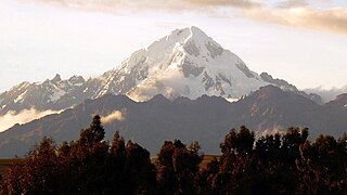
Veronica, also called Huacrahuilki, Huacay Huilcay, Wayna Willka,Waqaywillka, Urubamba, or Padre Eterno, is a 5,893 m (19,334 ft) mountain in the Urubamba mountain range in the Andes of Peru. It is located in the Cusco Region, La Convención Province, Huayopata District, and in the Urubamba Province, Ollantaytambo District northwest of the town of Ollantaytambo.

Ccerayoc is a 5,092-metre-high (16,706 ft) mountain in the Urubamba mountain range in the Andes of Peru. It is located in the Cusco Region, Calca Province, in the districts Calca and Lares. It lies immediately east of Sahuasiray and northeast of Condorhuachana.
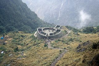
Runkuraqay or Runku Raqay is an archaeological site on a mountain of the same name in Peru located in the Cusco Region, Urubamba Province, Machupicchu District. It is situated southeast of the archaeological site Machu Picchu and south of the Vilcanota river. The ruins lie on the southern slope of the mountain Runkuraqay near the Runkuraqay pass, northeast of the archaeological site Sayacmarca and southeast of the site Qunchamarka.

Pucaorjo is a 4,776-metre-high (15,669 ft) mountain in the Urubamba mountain range in the Andes of Peru. It is situated in the Cusco Region, Calca Province, Lares District. Pucaorjo is situated northeast of Sirihuani, northwest of Sahuasiray and east of Parorjo, at the Lares trek. One of the nearest populated places is Quishuarani.
Parorjo is a mountain in the Urubamba mountain range in the Andes of Peru. It is situated in the Cusco Region, Calca Province, Lares District. Its summit is 4,891 m (16,047 ft) high. Parorjo is situated at the Lares trek north of Chicón and Sirihuani and west of Pucaorjo. One of the nearest populated places is Quishuarani. There is a small lake at its feet named Parococha.
Condorhuachana is a 5,073-metre-high (16,644 ft) mountain in the Urubamba mountain range in the Andes of Peru. It is located in the Cusco Region, Calca Province, Calca District, north of the Vilcanota River. Condorhuachana is situated northeast of Huamanchoque, southeast of Sirihuani and Sahuasiray, and southwest of Ccerayoc.

Huamanchoque is a 5,156-metre-high (16,916 ft) mountain in the Urubamba mountain range in the Andes of Peru. It is located in the Cusco Region, Calca Province, Calca District, north of the Vilcanota River. Huamanchoque lies at the Cancha Cancha valley where the Lares trek route passes by. It is situated south of Canchacanchajasa, southwest of Sahuasiray and Cóndorhuachana, and north of a lower peak named Cóndorhuachana. One of the nearest towns is Huayllabamba.
Yanaorjo is a mountain in the Urubamba mountain range in the Andes of Peru, about 4,800 metres (15,748 ft) high. It lies in the Cusco Region, Calca Province, Calca District. Yanaorjo is situated southeast of Sahuasiray, south of Ccerayoc, north of Ajosune or Aqosune and Apurinru and northwest of Pumacallanca and Llamayojcasa.
Chulluncunayoc is a mountain in the Andes of Peru, about 4,800 metres (15,748 ft) high. It lies in the Cusco Region, Calca Province, Calca District, east of the Urubamba mountain range. Chulluncunayoc is situated northeast of Ccerayoc and Pachacútec and southwest of Yanacaca.
Carhuascancha or Tumarinaraju is a mountain in the Cordillera Blanca in the Andes of Peru with an elevation of 5,648 metres (18,530 ft) or 5,668 metres (18,596 ft) above sea level. It is situated in the Ancash Region, Huari Province, Huantar District, and in the Huaraz Province, Huaraz District. Carhuascancha lies north-west of Huantsán.
Patacancha is a 4,666-metre-high (15,308 ft) mountain in the Urubamba mountain range in the Andes of Peru. It is located in the Cusco Region, Urubamba Province, Ollantaytambo District. Patacancha lies at the Patacancha River above the village of Patacancha, northeast of Huarmaripayoc and southeast of Huacratanca.
Yanaorcco is a mountain in the Urubamba mountain range in the Andes of Peru, about 4,800 metres (15,748 ft) high. It lies in the Cusco Region, Calca Province, Lares District. Yanaorcco is situated northwest of Ccerayoc and northeast of Sahuasiray.
Chaquicocha is a 4,895-metre-high (16,060 ft) mountain at a little lake of that name in the Urubamba mountain range in the Andes of Peru. It is located in the Cusco Region, Calca Province, Calca District, and in the Urubamba Province, in the districts of Huayllabamba and Yucay. It lies southwest of Huamanchoque and southeast of Chicon.
Llamayojcasa, also known as Qochaqollur, is a mountain in the eastern extensions of the Urubamba mountain range in the Andes of Peru, about 4,600 m (15,092 ft) high. It is located in the Cusco Region, Calca Province, Calca District. It lies southeast of Ccerayoc. This is where the archaeological site of Llamayuq is situated.
Coscojahuarina is a mountain in the eastern extensions of the Urubamba mountain range in the Andes of Peru, about 4,600 m (15,100 ft) high. It is located in the Cusco Region, Calca Province, Calca District. It lies southeast of Huamanchoque and Pitusiray.
Maquimaquiyoc is a mountain in the eastern extensions of the Urubamba mountain range in the Andes of Peru, about 4,200 m (13,800 ft) high. It is located in the Cusco Region, Calca Province, Calca District. It lies east of Coscojahuarina and southeast of Huamanchoque and Pitusiray.
Coscojahuarina is a 4,623-metre-high (15,167 ft) mountain in the eastern extensions of the Urubamba mountain range in the Andes of Peru It is located in the Cusco Region, Calca Province, Calca District. It lies south of Llamayojcasa and west of the village of Totora.
Pucaccocha is a mountain in the Andes of Peru, about 4,600 m (15,100 ft) high It is located in the Cusco Region, Calca Province, Lares District. It lies in the eastern extensions of the Urubamba mountain range, northeast of Sahuasiray.
Qhapaq Kancha is an archaeological site in Peru of the Inca period on top of a mountain of the same name. It is located in the Cusco Region, Calca Province, Coya District.
Llaulliyoc is a mountain north of the Urubamba mountain range in the Andes of Peru, about 4,400 m (14,400 ft) high. It is located in the Cusco Region, La Convención Province, Ocobamba District, and in the Urubamba Province, Ollantaytambo District.


