
The Alpine Lakes Wilderness is a large wilderness area spanning the Central Cascades of Washington state in the United States. The wilderness is located in parts of Wenatchee National Forest and Snoqualmie National Forest, and is approximately bounded by Interstate 90 and Snoqualmie Pass to the south and U.S. Route 2 and Stevens Pass to the north. The Alpine Lakes is the largest wilderness area near the population centers of Puget Sound, counted at 414,161 acres (167,605 ha) following the 2014 expansion.

Dragontail Peak, also known as Dragon Tail, is a mountain in the Stuart Range, in Chelan County, Washington. While climbing an adjacent peak, Lex Maxwell, Bob McCall, and Bill Prater remarked that the needles on the crest, southwest of the summit, resembled a "dragon tail". The name was officially accepted in 1955. On the mountain's northeast flank lies Colchuck Lake which drains into Mountaineer Creek, and Colchuck Glacier lies below the western slopes of the peak. On its south side the mountain drops steeply to Ingalls Creek, which flows about 5,800 feet (1,800 m) below the summit.

Icicle Creek is a non navigable stream in the U.S. state of Washington. It originates at Josephine Lake near the crest of the Cascade Range and flows generally east to join the Wenatchee River near Leavenworth. Icicle Creek's drainage basin is mountainous and mostly undeveloped land within the Wenatchee National Forest and the Alpine Lakes Wilderness. The final 6 miles (10 km) of the creek are moderately developed with scattered homes and pasture, a golf course, children's camp, a small housing development called Icicle Island Club, and the Leavenworth National Fish Hatchery. Some water is diverted from the creek for municipal use by the City of Leavenworth at Icicle Creek river mile 5.6. Near Leavenworth, the wheelchair-accessible Icicle Creek Nature Trail, a National Recreation Trail designated in 2005, runs 1.0 mile (1.6 km) along a historic creek channel.

Chikamin Peak is a 7,000+ ft mountain summit located in the cascade Range, in Kittitas County of Washington state. It is situated within the Alpine Lakes Wilderness, on land managed by the Okanogan–Wenatchee National Forest. The mountain's name "Chikamin" derives from Chinook Jargon meaning "money" or "metal", and was submitted by Edmond S. Meany, president of The Mountaineers. This name was officially adopted in 1916 by the U.S. Board on Geographic Names. Chikamin Peak is the highest point of Chikamin Ridge, 6 mi (9.7 km) northeast of Snoqualmie Pass. Other notable peaks on Chikamin Ridge include Four Brothers and Three Queens. Precipitation runoff from this mountain drains into tributaries of the Yakima River. The Pacific Crest Trail traverses the southwest slope of Chikamin Ridge, and from the trail a scramble up a gully leads to the summit and several alpine lakes including Chikamin Lake and Spectacle Lake.
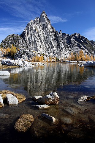
Prusik Peak is an 8000+ ft granite summit located at the west end of The Temple in Chelan County of Washington state. Prusik Peak is part of The Enchantments within the Alpine Lakes Wilderness, and is often the iconic photographic image of both areas. Prusik Peak belongs to the Stuart Range which is a subset of the Cascade Range. The name honors Dr. Karl Prusik (1896–1961) who was an Austrian mountaineer, and is known as the inventor of the prusik, a rope knot which happened to be used to gain access to the summit horn during the first ascent by Fred Beckey in 1948. Precipitation runoff drains into Icicle Creek, a tributary of the Wenatchee River.
Cannon Mountain is an 8,638 ft mountain summit located in Chelan County of Washington state. Cannon Mountain is part of The Enchantments, within the Alpine Lakes Wilderness. Cannon Mountain belongs to the Stuart Range which is subset of the Cascade Range. Cannon Mountain is situated one mile north of Enchantment Peak. The nearest higher peak is Dragontail Peak, 2.15 mi (3.46 km) to the southwest. Precipitation runoff drains into Icicle Creek, a tributary of the Wenatchee River.

Cashmere Mountain is an 8,501-foot (2,591-metre) mountain summit located in Chelan County of Washington state. Cashmere Mountain is situated within the Alpine Lakes Wilderness, on land managed by the Okanogan–Wenatchee National Forest. It is part of the Wenatchee Mountains which are subset of the Cascade Range. Its nearest higher neighbor is Cannon Mountain, 4.4 mi (7.1 km) to the southeast. Precipitation runoff from this mountain drains into tributaries of Icicle Creek, which in turn is a tributary of the Wenatchee River.

Hibox Mountain is a 6,547-foot (1,996-metre) mountain summit located in the Cascade Range in Kittitas County of Washington state. It is situated within the Alpine Lakes Wilderness on land managed by Okanogan-Wenatchee National Forest. The mountain's name "Hibox" is a portmanteau which is derived from its position as the high point of Box Ridge. The peak is five miles east of Snoqualmie Pass, and Alta Mountain lies 1.5 miles to the west-northwest of Hibox. Precipitation runoff from the mountain drains into Box Canyon Creek and Mineral Creek which both empty to Kachess Lake.
Big Snow Mountain is a prominent 6,680-foot (2,040-metre) mountain summit located 7 mi (11 km) north of Snoqualmie Pass in the Alpine Lakes Wilderness in eastern King County of Washington state. It is part of the Cascade Range and is situated on land managed by Mount Baker-Snoqualmie National Forest. Precipitation runoff from the mountain drains into tributaries of the Snoqualmie and Skykomish Rivers. The nearest higher peak is Overcoat Peak, 3.75 mi (6.04 km) to the east-southeast.

The Cradle is a prominent 7,467-foot (2,276-metre) double summit mountain located in Chelan County of Washington state. The mountain's name is derived from the depression between the two peaks of nearly identical elevation. The Cradle is situated within the Alpine Lakes Wilderness and is part of the Wenatchee Mountains, which is subset of the Cascade Range. Its nearest higher peak is Jack Ridge, 5.7 mi (9.2 km) to the east-southeast. Precipitation runoff from the mountain drains into tributaries of Icicle Creek, which in turn is a tributary of the Wenatchee River. The first ascent of the south peak was made in 1944 by Gene Paxton and Dwight Watson, whereas the north peak wasn't climbed until 1952 by Bill and Gene Prater.

Rampart Ridge is a 5,870 ft (1,790 m) elevation mountain ridge located in the Cascade Range, in Kittitas County of Washington state. It is situated northeast of Hyak, Washington, and the north end of Keechelus Lake, within the Alpine Lakes Wilderness, on land managed by Wenatchee National Forest. Its nearest higher peak is Alta Mountain, 1.74 mi (2.80 km) to the north-northeast, and Dungeon Peak rises 0.77 mi (1.24 km) to the south-southwest. The north-south trending ridge is characterized by vertical cliffs on its west-facing side above the Gold Creek valley, and gentle meadows with lakes on the eastern side, such as Rachel Lake, Lake Lillian, and the Rampart Lakes. The descriptive name of rampart was officially adopted 1918 by the United States Board on Geographic Names based on a suggestion by The Mountaineers. Precipitation runoff from the ridge drains into tributaries of the Yakima River.

Dungeon Peak is a 5,640+ ft mountain summit located in the Cascade Range, in Kittitas County of Washington state. It is situated northeast of Hyak, Washington, near the north end of Keechelus Lake, within the Alpine Lakes Wilderness, on land managed by Wenatchee National Forest. Its nearest higher neighbor is Rampart Ridge, 0.66 mi (1.06 km) to the north-northeast. The mountain is set above the Gold Creek valley on the western side, and Lake Lillian on the eastern side. Precipitation runoff from the peak drains into tributaries of the Yakima River.
Ingalls Peak is a 7,662-foot (2,335-metre) triple-summit mountain located in the Alpine Lakes Wilderness, along the common border of Kittitas County and Chelan County, in Washington state. Ingalls Peak is the highest point in the Teanaway area of the Wenatchee Mountains. It is situated 2 mi (3.2 km) west of Mount Stuart, and immediately west of Lake Ingalls, on land managed by Wenatchee National Forest. Its subpeaks are the South Peak and the East Peak. Precipitation runoff from the peak drains north into Jack Creek, a tributary of Icicle Creek; west into Fortune Creek; or east into Ingalls Creek, a tributary of the Wenatchee River. This peak, the lake, creek, and pass are named for Captain Benjamin Ingalls of the United States Cavalry who led an 1855 survey of this area and is credited with discovering gold in the region.

Burnt Boot Peak is a 6,520+ ft mountain summit located in the Alpine Lakes Wilderness in eastern King County of Washington state. The peak is part of the Cascade Range and is one mile east of the crest of the range. Burnt Boot Peak is situated 6.5 mi (10.5 km) northeast of Snoqualmie Pass on land managed by Mount Baker-Snoqualmie National Forest. Huckleberry Mountain is set 1.87 mi (3.01 km) to the south, and the nearest higher neighbor is Lemah Mountain, 1.34 mi (2.16 km) to the east. This unofficially-named mountain is located at the head of the officially-named Burnboot Creek, variant spelling Burntboot Creek. Precipitation runoff from the mountain drains south into this creek, or north into Middle Fork Snoqualmie River. The first ascent of this peak was made in August 1963 by Phil Weiser and Clarke Stockwell. The first ascent via the north ridge route was made in June 1971 by Don Williamson, Tom Oas, and Bill Bucher.

Big Lou is a 7,780+ ft mountain summit located in Chelan County of Washington state. It is situated 8.5 mi (13.7 km) west-northwest of Leavenworth, on the boundary of the Alpine Lakes Wilderness, and on land managed by the Okanogan–Wenatchee National Forest. Big Lou is the highest point on Icicle Ridge, and is the third-highest peak in the Chiwaukum Mountains, a subset of the Cascade Range. Its nearest higher neighbor is Snowgrass Mountain, 5 mi (8.0 km) to the northwest, and slightly lower Big Jim Mountain is set 1.75 mi (2.82 km) to the north-northeast. Precipitation runoff from Big Lou drains into Icicle Creek and other tributaries of the Wenatchee River. Although modest in elevation, relief is significant since Big Lou rises 5,200 feet above Icicle Creek Valley in approximately two miles. Big Lou is named for mountaineer Lou Whittaker, the twin brother of Jim Whittaker, the first American to summit Mount Everest.
Lake Kanim is a set of small freshwater lakes located on a clif of the south skirt of Lennox Mountain, in King County, Washington. Lake Kanim is the nascent source of the North Fork of the Snoqualmie River. The lake and its accompanying waterfall were named after Jerry Kanim who was the leader of Snoqualmie people.
Coney Lake is a small alpine lake located in the Alpine Lakes Wilderness in King County, Washington. Coney Lake sits in a bowl formed by a rocky double cliff bifurcation of the south ridge of Lennox Mountain that connects to Coney's Cones-South Peak. Coney Lake is the origin of Coney Creek, which is a tributary of the west fork of Miller River. Lake Kanim is situated over the opposite side of the ridge as Lennox Mountain splits towards Canoe Peak.
Lennox Mountain is an 5,898-foot (1,798 m) mountain summit located in King County of Washington state. Lennox mountain extends a ridge South towards Canoe peak making a bowl structure where Lake Kanim sits, the origin source of the North Fork of the Snoqualmie River. From Lennox Mountain a second ridge with rocky double cliffs is formed running East towards Coney's Cones-South Peak where the Coney Basin and Coney Lake sit which produces a tributary of the west fork of Miller River. Access to Lennox Mountain is from Bare Mountain trailhead which reaches Canoe Peak.
Shield Lake is a small alpine lake located in the Enchantments region of the Alpine Lakes Wilderness in Chelan County, Washington. Shield Lake sits in a bowl formed by a rocky cliff bifurcation of the east skirt of Cannon Mountain that connects to Elf Ridge Peak. Shield Lake has an outflow that is the inflow of Earle Lake and Mesa Lake less than a mile Northeast towards Rat Creek. The creek joins the outflow of Coney Lake, a tributary of Icicle Creek. Coney Lake is situated over the opposite side over Elf Ridge. The lake is home to cutthroat trout and other fish.


