Conil de la Frontera

Last updated
Conil de la Frontera
Conilbuildings.jpg
Conil de la frontera bandera.png
Flag
Coat of Arms of Conil de la Frontera.svg
Coat of arms
Cadiz-loc.svg
Red pog.svg
Conil de la Frontera
Location in the Province of Cádiz
Spain Andalusia location map.svg
Red pog.svg
Conil de la Frontera
Location in Andalusia
Spain location map.svg
Red pog.svg
Conil de la Frontera
Location in Spain
Coordinates: 36°16′N6°5′W / 36.267°N 6.083°W / 36.267; -6.083 Coordinates: 36°16′N6°5′W / 36.267°N 6.083°W / 36.267; -6.083
Country Flag of Spain.svg  Spain
Autonomous community Flag of Andalucia.svg  Andalusia
Province Flag Cadiz Province.svg  Cádiz
Comarca La Janda
Government
  MayorJuan Manuel Bermúdez Escámez (Izquierda Unida)
Area
  Total88.51 km2 (34.17 sq mi)
Elevation
41 m (135 ft)
Population
 (2018) [1]
  Total22,427
  Density250/km2 (660/sq mi)
Demonym(s) Conileños
Time zone UTC+1 (CET)
  Summer (DST) UTC+2 (CEST)
Postal code
11140
Website Official website

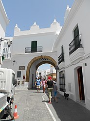
Conil de la Frontera is one of the White Towns of Andalusia in the province of Cadiz (region of Andalusia), located on the Atlantic coast in the southern part of Spain, with around 22,000 inhabitants. In summer its population exceeds 90,000 inhabitants.

It has six beaches: Playa La Fontanilla, Playa El Roqueo (with a 1936 Civil War bunker), Playa Fuente del Gallo, Playa Punta Lejos, Playa Cala del Aceite and Playa los Bateles. Playa los Bateles is the longest and the most popular in the summer. Conil de la Frontera is primarily a vacation town and the most of the tourists are Spanish although you often also hear German as well in town.

Every Friday you can visit the market on Avda. de la Música, which includes culture and history. The market includes many little trinkets and handmade clothes. The beach is sandy and has volleyball nets.

Conil de la Frontera Vista de Conil de la Frontera, Espana, 2015-12-08, DD 01.JPG
Conil de la Frontera

Related Research Articles

Andalusia Autonomous community of Spain

Andalusia is the southernmost autonomous community in Peninsular Spain. It is the most populous and the second largest autonomous community in the country. The Andalusian autonomous community is officially recognised as a "historical nationality". The territory is divided into eight provinces: Almería, Cádiz, Córdoba, Granada, Huelva, Jaén, Málaga, and Seville. Its capital city is Seville. The seat of the High Court of Justice of Andalusia is located in the city of Granada.

Province of Málaga Province of Spain

The province of Málaga is located on the southern mediterranean coast of Spain, in Andalusia. It is bordered by the Mediterranean Sea to the south and by the provinces of Cádiz, Seville, Córdoba, and Granada (clockwise).

Province of Cádiz Province of Spain

Cádiz is a province of southern Spain, in the southwestern part of the autonomous community of Andalusia. It is the southernmost part of mainland Spain, as well as the southernmost part of continental Europe.

Los Realejos Municipality in Canary Islands, Spain

Los Realejos is a town and a municipality in the northern part of the island of Tenerife, which is the biggest of the Canary Islands. It is part of the province of Santa Cruz de Tenerife, Spain. The town is located 2 km from the north coast, 5 km southwest of Puerto de la Cruz, 6 km west of La Orotava, and 34 km southwest of the island's capital Santa Cruz de Tenerife. The inhabitants are known in Spanish as realejeros.

Torrevieja Municipality in Valencian Community, Spain

Torrevieja or Torrevella is a seaside city and municipality located on the Costa Blanca in the province of Alicante, in the southern part of the Valencian Country, on the southeastern Mediterranean coast of Spain.

Jerez de la Frontera Municipality in Andalusia, Spain

Jerez de la Frontera, or simply Jerez, is a Spanish city and municipality in the province of Cádiz in the autonomous community of Andalusia, in southwestern Spain, located midway between the Atlantic Ocean and the Cádiz Mountains. As of 2015, the city, the largest in the province, had a population of 212,876. It is the fifth largest in Andalusia, and has become the transportation and communications hub of the province, surpassing even Cádiz, the provincial capital, in economic activity. Jerez de la Frontera is also, in terms of land area, the largest municipality in the province, and its sprawling outlying areas are a fertile zone for agriculture. There are also many cattle ranches and horse-breeding operations, as well as a world-renowned wine industry (Xerez).

Benalmádena Municipality in Andalusia, Spain

Benalmádena is a town in Andalusia in southern Spain, 12 km west of Málaga, on the Costa del Sol between Torremolinos and Fuengirola.

Estepona Municipality in Andalusia, Spain

Estepona is a town and municipality in the comarca of the Costa del Sol, southern Spain. It is located in the province of Málaga, part of the autonomous community of Andalusia. Its district covers an area of 137 square kilometers in a fertile valley crossed by small streams and a mountainous areas dominated by the Sierra Bermeja, which reaches an elevation of 1,449 m at the peak of Los Reales.

Sanlúcar de Barrameda Municipality in Andalusia, Spain

Sanlúcar de Barrameda, or simply Sanlúcar, is a city in the northwest of Cádiz province, part of the autonomous community of Andalucía in southern Spain. Sanlúcar is located on the left bank at the mouth of the Guadalquivir River opposite the Doñana National Park, 52 km from the provincial capital Cádiz and 119 km from Sevilla capital of the autonomous region Andalucía. Its population is 68,656 inhabitants.

White Towns of Andalusia series of whitewashed towns in southern Spain

The White Towns of Andalusia, or Pueblos Blancos, are a series of whitewashed towns and large villages in the northern part of the provinces of Cádiz and Málaga in southern Spain, mostly within the Sierra de Grazalema Natural Park.

Morón de la Frontera Municipality in Andalusia, Spain

Morón de la Frontera is a Spanish town in Seville province, Andalusia, 57 km (35 mi) South-East of Seville. Situated in the south of the province, it is the center of the region that bears the same name and is the head of one of the 85 judicial courts of Andalucia.

El Puerto de Santa María Municipality in Andalusia, Spain

El Puerto de Santa María, locally known as El Puerto, is a municipality located on the banks of the Guadalete River in the province of Cádiz, Andalusia. As of 2016, the city has a population of c. 88,184, of which some 50,000 live in the urban center, and the remainder in the surrounding areas.

Motril Municipality in Andalusia, Spain

Motril is a town and municipality on the Mediterranean coast in the province of Granada, Spain. It is the second largest town in the province, with a population of 60,368 as of 2016. The town is located near the Guadalfeo River and 69 km (43 mi) from Granada. The council of Motril includes the city of Motril and the neighbourhoods of El Varadero, Carchuna, Calahonda, Puntalón, Playa Granada, Las Ventillas, La Perla, La Garnatilla and La Chucha. The town is the capital of the region of the Coast of Granada.

Ubrique Municipality in Spain

Ubrique is a municipality of Spain located in the province of Cádiz, in the autonomous community of Andalusia. According to the 2005 census, it has a population of 17,362 inhabitants. It is the most important municipality in the Sierra de Cádiz.

Chiclana de la Frontera Municipality in Andalusia, Spain

Chiclana de la Frontera is a town and municipality in southwestern Spain, in the province of Cádiz, Andalucía, near the Gulf of Cádiz. It belongs to the association of municipalities of the Bay of Cádiz, the provincial capital of Cádiz, Jerez de la Frontera, San Fernando, El Puerto de Santa María, Puerto Real and Rota which form the third largest metropolitan area in Andalusia, behind Seville and Málaga, and the twelfth largest in Spain. It is located 20 kilometres south-east from Cádiz, and borders the municipalities of San Fernando and Puerto Real to the north. In 1877, the municipality's population was 11,677; in 2012, it was 81,473. It has a surface area is 203 square kilometres (78 sq mi) and a population density of 401 inhabitants / km2. The average elevation is 11 metres (36 ft) above sea level. The economy depends largely upon modern industry, especially salt processing and tourism, and the municipality is known for its beaches such as the 6 kilometres (3.7 mi) long Playa de la Barrosa, hotels and golf courses in the resort of Novo Sancti Petri. The municipality contains the largest number of hotel beds in the Province of Cádiz and the Costa de la Luz. The town's newspaper, Chiclana Información, is distributed on Saturday mornings.

Conil CF Association football club in Spain

Conil Club de Fútbol is a Spanish football team based in Conil, in the autonomous community of Andalusia. Founded in 1931, it plays in Tercera División – Group 10, holding home games at Estadio José Antonio Pérez Ureba, with a 1,500-seat capacity.

San José (Almeria) Place in Andalusia, Spain

San José is a village and fishing port in the centre of Parque Natural de Cabo de Gata, in the Province of Almería. Its population in 2011 was 1012 inhabitants. Recorded by the INE.

El Palmar de Vejer Village in Andalusia, Spain

El Palmar de Vejer is a village in the municipality of Vejer de la Frontera in the Province of Cadiz, which stretches for 8 km along the Atlantic coast. It is 11 kilometers away from the municipality of Vejer de la Frontera, of which it is part.

References

  1. Municipal Register of Spain 2018. National Statistics Institute.
Harbor of Conil de la Frontera Harbor of Conil.jpg
Harbor of Conil de la Frontera