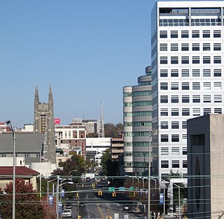
Fairfield County is a county in the southwestern corner of the U.S. state of Connecticut. It is the most populous county in the state and was also its fastest-growing from 2010 to 2020. As of the 2020 census, the county's population was 957,419, representing 26.6% of Connecticut's overall population. The closest to the center of the New York metropolitan area, the county contains four of the state's top 7 largest cities—Bridgeport (1st), Stamford (2nd), Norwalk (6th), and Danbury (7th)—whose combined population of 433,368 is nearly half the county's total population.

Shelton is a city in Fairfield County, Connecticut, United States. The population was 40,869 at the 2020 United States Census.

Stratford is a town in Fairfield County, Connecticut, United States. It is situated on Long Island Sound at the mouth of the Housatonic River. Stratford is in the Bridgeport–Stamford–Norwalk Metropolitan Statistical Area. It was settled by Puritans in 1639.

Route 34 is a primary state highway in the U.S. state of Connecticut. Route 34 is 24.37 miles (39.22 km) long, and extends from Washington Avenue near I-84/US 6 in Newtown to the junction of I-95 and I-91 in New Haven. The highways connects the New Haven and Danbury areas via the Lower Naugatuck River Valley. The portion of the route between New Haven and Derby was an early toll road known as the Derby Turnpike.
U.S. Route 3 (US 3) is a United States Numbered Highway running 277.90 miles (447.24 km) from Cambridge, Massachusetts, through New Hampshire, to the Canada–US border near Third Connecticut Lake, where it connects to Quebec Route 257.

Route 15 is a state highway in the U.S. state of Connecticut that runs 83.53 miles (134.43 km) from a connection with New York's Hutchinson River Parkway in Greenwich, Connecticut, to its northern terminus intersecting with Interstate 84 (I-84) in East Hartford, Connecticut. Route 15 consists of four distinct sections: the Merritt Parkway, the Wilbur Cross Parkway, the Berlin Turnpike, and part of the Wilbur Cross Highway. The unified designation was applied to these separate highways in 1948 to provide a continuous through route from New York to Massachusetts. The parkway section of Route 15 is often referred to locally as "The Merritt".
U.S. Route 1A (US 1A) is the name of several highways found in the United States.

Route 8 is a 67.36-mile (108.41 km) state highway in Connecticut that runs north–south from Bridgeport, through Waterbury, all the way to the Massachusetts state line where it continues as Massachusetts Route 8. Most of the highway is a four-lane freeway but the northernmost 8.8 miles (14.2 km) is a two-lane surface road.

Interstate 95 (I-95) is the main north–south Interstate Highway on the East Coast of the United States, running in a general east–west compass direction for 111.57 miles (179.55 km) in Connecticut, from the New York state line to the Rhode Island state line. I-95 from Greenwich to East Lyme is part of the Connecticut Turnpike, during which it passes through the major cities of Stamford, Bridgeport, and New Haven. After leaving the turnpike in East Lyme, I-95 is known as the Jewish War Veterans Memorial Highway and passes through New London, Groton, and Mystic, before exiting the state through North Stonington at the Rhode Island border.
Route 72 is a state highway in the western part of the Greater Hartford area. Route 72 is an L-shaped route with a north–south section in Plymouth and Harwinton and an east–west section from Bristol to New Britain. Route 72 is a freeway from Route 9 in New Britain to Route 372 in Plainville. Although ConnDOT logs it as a north-south route, it is signed as east-west with the exception of signage on route 4 at its northwest terminus for route 72 south.
Route 113 is a 50.53-mile-long (81.32 km) east–west Massachusetts state route that connects towns in the Merrimack River valley in northeastern Massachusetts. Its western terminus is at Route 119 in Pepperell, and its eastern end is at U.S. Route 1 and Route 1A in Newburyport.

Pennsylvania Route 320 is a north–south state highway in southeastern Pennsylvania. The southern terminus of the 18.8-mile (30.3 km) long route is at U.S. Route 13 /PA 291 in Chester. The northern terminus is at PA 23 in Swedeland. The route passes through suburban areas in Delaware and Montgomery counties to the west of Philadelphia, serving Swarthmore, Springfield, Broomall, Villanova, and Gulph Mills. PA 320 intersects many important highways including US 13 Business and Interstate 95 (I-95) in Chester, US 1 in Springfield, US 30 in Villanova, and I-76 in Gulph Mills. PA 320 runs parallel to I-476 for much of its length and crosses it four times. Even though there are no direct interchanges between I-476 and PA 320, several roads that intersect PA 320 provide access to I-476.
Route 100 is a state highway in Connecticut that connects the town center of East Haven with the Foxon community in the northern part of town.

Route 154 is a state highway in Connecticut running for 28.24 miles (45.45 km). It serves as one of the main thoroughfares in the town of Old Saybrook, intersecting twice with U.S. Route 1. North of I-95, Route 154 runs parallel to Route 9, along to the west bank of the Connecticut River. The route ends in Middletown at Route 9.

Route 110 is a state highway in Connecticut running for 15.95 miles (25.67 km) from US 1 in Stratford to Route 111 in Monroe.
Route 108 in the U.S. state of Connecticut, locally called Nichols Avenue and Huntington Turnpike, is a two-lane state highway that runs northerly from US 1, Boston Post Road in Stratford, through Trumbull, to Route 110 in downtown Shelton. Originally called the Farm Highway, it was laid out to the south side of Mischa Hill in Trumbull on December 7, 1696 and is considered to be the third oldest documented highway in Connecticut after the Mohegan Road in Norwich (1670) and the Boston Post Road or US 1 (1673).
Route 146 is a state road that serves as a scenic alternative to US 1 between Branford and Guilford in the U.S. state of Connecticut. Route 146 is 13.00 miles (20.92 km) long, with 8.36 miles (13.45 km) in Branford and 4.64 miles (7.47 km) in Guilford.

U.S. Route 1 (US 1) in the U.S. state of Connecticut is a major east–west U.S. Route along Long Island Sound. It has been replaced by Interstate 95 (I-95) as a through route, which it closely parallels, and now primarily serves as a local business route. Despite its largely east–west orientation, it is part of a north–south route and is mostly signed north–south.

Route 127 is a state highway in southwestern Connecticut, running entirely from Bridgeport to Trumbull. It serves as a minor arterial, connecting all four major limited access highways in the Bridgeport area.

Route 130 is a state highway in southwestern Connecticut, running from Fairfield to Stratford, generally parallel to I-95.


