
Argyll and Bute is one of 32 unitary council areas in Scotland and a lieutenancy area. The current lord-lieutenant for Argyll and Bute is Jane Margaret MacLeod. The administrative centre for the council area is in Lochgilphead at Kilmory Castle, a 19th-century Gothic Revival building and estate. The current council leader is Councillor Jim Lynch.

The village of Ballachulish in Lochaber, Highland, Scotland, is centred on former slate quarries, and now primarily serves tourists in the area.

The West Highland Line is a railway line linking the ports of Mallaig and Oban in the Scottish Highlands to Glasgow in Central Scotland. The line was voted the top rail journey in the world by readers of independent travel magazine Wanderlust in 2009, ahead of the notable Trans-Siberian line in Russia and the Cuzco to Machu Picchu line in Peru. The ScotRail website has since reported that the line has been voted the most scenic railway line in the world for the second year running.

The Falls of Lora is a tidal race which forms at the mouth of Loch Etive when a particularly high tide runs out from the loch. They form white water rapids for two to five days either side of the spring tides.

Loch Etive is a 30 km sea loch in Argyll and Bute, Scotland. It reaches the sea at Connel, 5 km north of Oban. It measures 31.6 km long and from 1.2 km to 1.6 km (1 mi) wide. Its depth varies greatly, up to a maximum of 150 m (490 ft).
The Callander and Oban Railway company was established with the intention of linking the sea port of Oban to the railway network. This involved a long line from Callander through wild and thinly populated terrain, and shortage of money meant that the line was opened in stages from 1866 to 1880.

Oban railway station is a railway station serving Oban in Scotland. It is the terminus of one branch of the highly scenic West Highland Line, sited 71 miles 44 chains (115.1 km) from Callander, via Glen Ogle. It was originally the terminus of the Callander and Oban Railway. All services are operated by ScotRail, who also manage the station.

Falls of Cruachan railway station is a railway station located at the foot of Ben Cruachan in Scotland. This station is on the Oban branch of the West Highland Line, originally part of the Callander and Oban Railway. It is sited between Taynuilt and Loch Awe, sited 52 miles 69 chains (85.1 km) from Callander via Glen Ogle. ScotRail manage the station and operate all services.

Connel Ferry railway station is a railway station serving the village of Connel in western Scotland. This station is on the Oban branch of the West Highland Line, originally part of the Callander and Oban Railway, between Oban and Taynuilt, sited 65 miles 30 chains (105.2 km) from Callander via Glen Ogle. All services are operated by ScotRail, who also manage the station.

The West Highland Railway was a railway company that constructed a railway line from Craigendoran to Fort William and Mallaig. The line was built through remote and difficult terrain in two stages: the section from Craigendoran to Fort William opened in 1894, with a short extension to Banavie on the Caledonian Canal opening in 1895.

Connel is a village in Argyll and Bute, Scotland. It is situated on the southern shore of Loch Etive. The Lusragan Burn flows through the village and into the loch.

Taynuilt is a large village in Argyll and Bute, Scotland located at the western entrance to the narrow Pass of Brander.

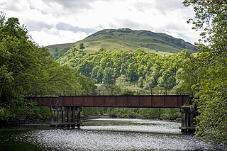
North Connel was a railway station located in North Connel, Argyll and Bute, on the north shore of Loch Etive. Its location was at the north end of Connel Bridge. It was on the Ballachulish branch line that linked Connel Ferry, on the main line of the Callander and Oban Railway, with Ballachulish.
The Lochearnhead, St Fillans and Comrie Railway company was formed to build a line along the valley of Strathearn, closing the gap between the Callander and Oban line of the Caledonian Railway and Crieff. Tourism was on the increase in the area, and there were ambitious ideas that imported goods traffic at Oban would be routed to the eastern Scotland towns and cities over the line.
The Killin Railway was a locally promoted railway line built to connect the town of Killin to the Callander and Oban Railway main line nearby. It opened in 1886, and carried tourist traffic for steamers on Loch Tay as well as local business. The directors and the majority of the shareholders were local people, and the little company retained its independence until 1923.
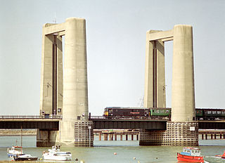
The Kingsferry Bridge is a combined road and railway vertical-lift bridge which connects the Isle of Sheppey to mainland Kent in South East England. The seven-span bridge has a central lifting span which allows ships to pass.
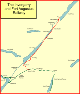
The Invergarry and Fort Augustus Railway was a branch-line railway built in Scotland, connecting the named places with the main line at Spean Bridge. It opened in 1903.
National Cycle Route 78 runs from Campbeltown to Inverness. It was officially launched as the Caledonia Way in 2016 as part of the wider redevelopment of Scotland's cycle network. It runs from the Kintyre peninsula to the Great Glen and the route varies from on road to traffic-free forest trails and canal paths.

The Falls of Cruachan derailment occurred on 6 June 2010 on the West Highland Line in Scotland, when a passenger train travelling between Glasgow and Oban hit boulders on the line and derailed near Falls of Cruachan railway station, after a landslide. There was a small fire and one carriage was left in a precarious position on the 50-foot-high (15-metre) embankment. Sixty passengers were evacuated, some with minor injuries; eight of those were hospitalised as a precaution. However, no people were killed. In addition to blocking the line, the incident also caused the closure of the A85 road below the rail line. Both road and rail were closed for a week.

The River Awe is a short river in Argyll and Bute, Southwest Highlands of Scotland by which the freshwater Loch Awe empties into Loch Etive, a sea loch. The river flows from a barrage which stretches across the end of a deep arm of the loch which protrudes northwestward through the Pass of Brander from the northeast–southwest aligned Loch Awe. The river is accompanied for much of its length both by the railway from Glasgow to Oban and by the A85 road both of which cross the river halfway along its length. The Awe is also crossed by a minor road bridge and a foot bridge.


