
Conset Bay is a bay on the east coast of Barbados. Near the community of St. Marks, [1] it lies off the southeastern shoreline of the Parish of St. John. [2]
Conset Bay is a bay on the east coast of Barbados. Near the community of St. Marks, [1] it lies off the southeastern shoreline of the Parish of St. John. [2]

Bridgetown is the capital and largest city of Barbados. Formerly The Town of Saint Michael, the Greater Bridgetown area is located within the parish of Saint Michael. Bridgetown is sometimes locally referred to as "The City", but the most common reference is simply "Town". As of 2014, its metropolitan population stands at roughly 110,000.

Holetown, is a small city located in the Caribbean island nation of Barbados. Holetown is located in the parish of Saint James on the sheltered west coast of the island.

The parish of Saint John is a parish of Barbados on the eastern side of the island. It is home to one of its secondary schools, The Lodge School. The parish is the home of many districts such as Ashford and Kendal. It is home to the St. John's Parish Church, which has a scenic view of the Atlantic Ocean from its perch near Hackleton's Cliff, which overlooks the East Coast of the island. In its southeastern corner, the shoreline turns northward, forming the small Conset Bay.

Cave Hill, St. Michael is a suburban area situated in the parish of St. Michael. It is located about 4 km north-west of the capital city Bridgetown along the west coast of Barbados.
Maycock's Bay is located between Six Men's Bay and Harrison Point in St. Lucy, the northwest of Barbados. It is on the west coast of the island to the north. The area has multiple cliffs extending from Bird Rock to Archers Bay and from Stroud Bay to Maycocks Bay.
Blades is a village in the parish of Saint Philip in Barbados. The Blades family is a powerful family, partly of which now resides in Ontario Canada.
Four Roads is a village in Saint Philip in Barbados.
Marchfield is a village in Saint Philip Parish in Barbados.
Saint Martins is a village in Saint Philip Parish in Barbados. It is a 5 minutes drive east of Sir Grantly Adams International Airports. Nearby villages include Rockhall, Gemswick, FoulBay, and Kirtons.

Saint Lawrence Gap, Christ Church is one of the best known neighbourhoods in the country of Barbados. Sometimes just called "The Gap", Saint Lawrence Gap is located on the southern coast of Barbados along the island's Highway 7. Found between Oistins to the east and Worthing to the west, Saint Lawrence Gap features a 1.5k kilometer stretch of bars, hotels, dance clubs, restaurants, inns, resorts, and shops along a white powdery-sand beachfront. It is situated roughly 5 km southeast of the capital city Bridgetown.
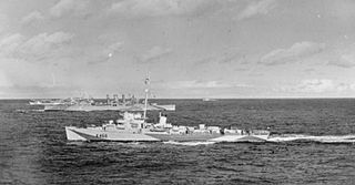
HMS Bickerton was a Captain-class frigate of the TE (Buckley) type during World War II. Named after Sir Richard Bickerton commander of HMS Terrible at the First Battle of Ushant during the American Revolutionary War.
Mangrove is a populated place in Barbados.
Bath is a populated place in the parish of Saint John, Barbados.
Branchbury is a populated place in the parish of Saint Joseph, Barbados.
Diamond Corner is a populated place in the parish of Saint Peter, Barbados.
The Castle is a populated place in the parish of Saint Peter, Barbados.
French Village is a populated place in the parish of Saint Peter, Barbados.
Boscobelle is a populated place in the parish of Saint Peter, Barbados.
Venture is a populated place in the parish of Saint John, Barbados.
Coordinates: 13°11′N59°28′W / 13.183°N 59.467°W
| | This Barbados location article is a stub. You can help Wikipedia by expanding it. |