
Dahlonega is the county seat of Lumpkin County, Georgia, United States. As of the 2010 census, the city had a population of 5,242, and in 2018 the population was estimated to be 6,884.

The Dahlonega Mint was a former branch of the United States Mint built during the Georgia Gold Rush to help the miners get their gold assayed and minted, without having to travel to the Philadelphia Mint. It was located at in Dahlonega, Lumpkin County, Georgia. Coins produced at the Dahlonega Mint bear the "D" mint mark. That mint mark is used today by the Denver Mint, which opened in 1906, over four decades after the Dahlonega Mint closed. All coins from the Dahlonega Mint are gold, in the $1, $2.50, $3, and $5 denominations, and bear dates in the range 1838–1861.

Skidoo was an unincorporated community in Inyo County, California. The geographical location of the old town site lies at an elevation of 5,689 feet. Skidoo is a ghost town located in Death Valley National Park. It is on the National Register of Historic Places.

Auraria is a ghost town in Lumpkin County, Georgia, United States, southwest of Dahlonega. Its name derives from aurum, the Latin word for gold. In its early days, it was also known variously as Dean, Deans, Nuckollsville, and Scuffle Town.

The Calhoun Mine is perhaps the oldest and best-known mine in Lumpkin County, Georgia. When gold was discovered in Lumpkin County in 1828, which led to the Georgia Gold Rush in 1829, it was discovered on 239 acres (0.97 km2) owned by Robert Obar. After at least two intermediary sales, the land was purchased by Senator John C. Calhoun of South Carolina, who was also the 7th Vice President of the United States. Calhoun started a mining company to mine the land and later allowed his son-in-law Thomas Green Clemson, the founder of Clemson University, to manage it. The ore deposit was a very rich deposit and, according to an 1856 letter from Clemson to his brother-in-law, was still producing significant quantities of gold nearly 30 years after its initial discovery on the land. This mine - along with the Consolidated Mine and the Loud Mine - were some of the most productive mines in the Georgia Gold Belt.
Crisson Mine was a gold mine in Lumpkin County, Georgia, USA, located just east of Dahlonega. Like many mines in the area, the property probably started as a placer mine during the Georgia Gold Rush. Once the placer deposits had been exhausted, an open pit gold mine was established in 1847 and commercial operations continued until the early 1980s. A small stamp mill was also established here. Much of the gold used for the gold leaf dome of the Georgia State Capitol was mined at this mine, which was among the most productive mines in the Georgia Gold Belt. The mine is located just north of the site of the Consolidated Mine, which is itself north of the Calhoun Mine.

The largest quantities of gold found in the eastern United States were found in the Georgia Gold Belt, extending from eastern Alabama to Rabun County, Georgia. The biggest concentration of gold was found in White, Lumpkin, and northern Cherokee counties in Georgia. The gold in the Georgia Gold Belt was close to 24 karat (100%) purity. Most of the gold was found in eroded rock (saprolite) and mixed in with quartz.

The Quincy Mine is an extensive set of copper mines located near Hancock, Michigan. The mine was owned by the Quincy Mining Company and operated between 1846 and 1945, although some activities continued through the 1970s. The Quincy Mine was known as "Old Reliable," as the Quincy Mine Company paid a dividend to investors every year from 1868 through 1920. The Quincy Mining Company Historic District is a United States National Historic Landmark District; other Quincy Mine properties nearby, including the Quincy Mining Company Stamp Mills, the Quincy Dredge Number Two, and the Quincy Smelter are also historically significant.
The Dahlonega Gold Museum Historic Site is a Georgia state historic site located in Dahlonega that commemorates America's first gold rush and the mining history of Lumpkin County. The museum is housed in the historic Old Lumpkin County Courthouse built in 1836 and located in the center of the town square. It is the oldest surviving county courthouse in the state. The museum houses many artifacts from the gold rush of 1836, including gold nuggets, gold coins, and gold panning equipment, as well as an educational film and gift shop.
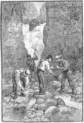
The Georgia Gold Rush was the second significant gold rush in the United States and the first in Georgia, and overshadowed the previous rush in North Carolina. It started in 1829 in present-day Lumpkin County near the county seat, Dahlonega, and soon spread through the North Georgia mountains, following the Georgia Gold Belt. By the early 1840s, gold became difficult to find. Many Georgia miners moved west when gold was found in the Sierra Nevada in 1848, starting the California Gold Rush. Since the 16th century, American Indians in Georgia told European explorers that the small amounts of gold which they possessed came from mountains of the interior. Some poorly documented accounts exist of Spanish or French mining gold in North Georgia between 1560 and 1690, but they are based on supposition and on rumors passed on by Indians. In summing up known sources, W.S. Yeates observed: "Many of these accounts and traditions seem to be quite plausible. Nevertheless, it is hardly probable that the Spaniards would have abandoned mines which were afterwards found to be quite profitable, as those in North Georgia."
The Free Jim Mine was a Georgia Gold Rush gold mine located in the town of Dahlonega in Lumpkin County, Georgia, United States. The mine was started by a free African American named James Boisclair, who arrived in the area in the 1830s from Augusta, Georgia. Apparently, Boisclair discovered gold on a tract of land but, under state law, could not purchase the land since he was black, except through a guardian. A local resident, Joseph J. Singleton became his custodian, consequently allowing Boisclair to purchase the land and start what would become known as the Free Jim Mine. The mine was operated by Bosclair for some years. Boisclair left Georgia following news of the California Gold Rush.

The Treadwell gold mine was on the south side of Douglas Island, .5-mile (0.80 km) east of downtown Douglas and southeast of downtown Juneau, owned and operated by John Treadwell. Composed of four sub-sites, Treadwell was in its time the largest hard rock gold mine in the world, employing over 2,000 people. Between 1881 and 1922, over 3 million troy ounces of gold were extracted. Not much remains today except for a few crumbling buildings and a "glory hole". Although John Treadwell had twelve years of experience in both placer and lode mines, he was a carpenter and builder by trade who had come to Alaska prior to the Klondike Gold Rush.
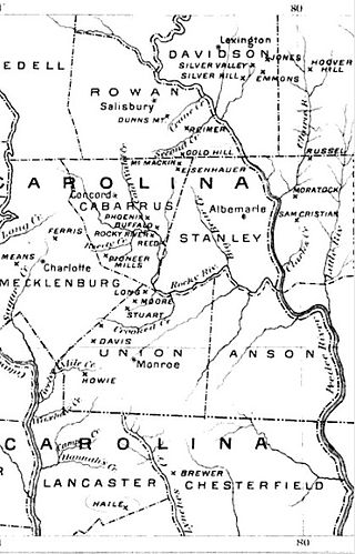
The Carolina Gold Rush, the first gold rush in the United States, followed the discovery of a large gold nugget in North Carolina in 1799, by a 12-year-old boy named Conrad Reed. He spotted the nugget while playing in Meadow Creek on his family's farm in Cabarrus County, North Carolina. Conrad took the 17-pound (7.7 kg) gold nugget home to show his father. However, gold was not commonly seen in their community and the value of the nugget was not understood. The nugget was used as a door stop in the family's home for several years. In 1802, Conrad's father, John Reed, showed the rock to a jeweler, who recognized it as gold and offered to buy it. Reed, still unaware of the real value of his "doorstop," sold it to the jeweler for US$3.50.

The Keane Wonder Mine and mill is an abandoned mining facility located within Death Valley National Park in Inyo County, California. It is located in the Funeral Mountains east of Death Valley and Furnace Creek, California

Harshaw is a ghost town in Santa Cruz County in the southeastern part of the U.S. state of Arizona. The town was settled in the 1870s, in what was then Arizona Territory. Founded as a mining community, Harshaw is named after the cattleman-turned-prospector David Tecumseh Harshaw, who first successfully located silver in the area. At the town's peak near the end of the 19th century, Harshaw's mines were among Arizona's highest producers of ore, with the largest mine, the Hermosa, yielding approximately $365,455 in bullion over a four-month period in 1880.

Independence is an extinct town located in Pitkin County, Colorado, United States. It is located at an elevation of 10,913 feet (3,326 m) 2.2 miles (3.6 km) directly west of Independence Pass. It was the first settlement established in the Roaring Fork Valley, after gold was struck in the vicinity on Independence Day, July 4, 1879, hence its name. Independence was served by three differently named post offices: Farwell from July 14, 1881, until July 3, 1882; Sparkill from February 1, 1882, until October 18, 1887; and Chipeta from April 20, 1899, until October 17, 1899. It has also been known historically as Mammoth City, Mount Hope, and Hunter's Pass.

Mabel Mill is a heritage-listed former stamper battery at Barton Street, Ravenswood, Charters Towers Region, Queensland, Australia. It was built from c. 1871 to c. 1902. It is also known as Mabel Mill and Partridge Mill. It was added to the Queensland Heritage Register on 28 January 1994.

Ravenswood Mining Landscape and Chinese Settlement Area is a heritage-listed former mining town and archaeological site on the reserve bounded by School Street, Cemetery Road, Railway Street and Burdekin Falls Dam Road, Ravenswood, Charters Towers Region, Queensland, Australia. It was added to the Queensland Heritage Register on 14 October 2016.
The Plymouth Trading Post is a brick building in Plymouth, California in Amador County, United States. The brick building was built in 1857 by hand by Joe Williams in 1857, to be his Trading Post. The Trading Post closed and the building became the headquarters of Plymouth Consolidated Mine in 1873. Plymouth Consolidated Mine was formed when a number of small mines combined. The building was the Plymouth Consolidated Mine main office and its commissary. Plymouth Trading Post is registered as California Historical Landmark #41, starting August 30, 1950. The Trading Post served the town and nearby Plymouth Mine. The building survived the 1877 that burned down much of the town. The brick walls foundations are 30 inches thick. The floor support beams are 12x12 inches of wood. Joe Williams "dug" the basement with dynamite to remove the shale rock below the building. There were hitching posts ring on the side of the building. Plymouth Consolidated Mine's Pacific shaft, was the deepest hard rock shaft at 4,450 feet by 1925 working the Plymouth gold vain. The main haul of gold was between 1883 and 1889, when it operated 160 stamps that crushed 400 tons of quartz ore a day. The Plymouth Consolidated Mine mined over $13,500,000 dollars of gold and closed in 1947. Some of the mines that Consolidated in 1883 were: Plymouth, Empire, and Amador Pacific mining companies. The mines were all located in the northern part of Mother Lode Gold Belt of the Sierra Nevada foothills at an elevation of 332 feet. After consolidation, the company had 126.3 acres of land that included: the Plymouth, Southerland, Oaks, Pacific, Simpson, Aden, Reese, Phoenix East claims, the Phoenix mill site, and interests in the Reese and Woolford, Indiana, Rising Star, Conville, and Beta claims. The first gold in the area was found in 1852. The Plymouth Consolidated Mine was idle from 1892 to 1911.


