Related Research Articles

Plate tectonics is the scientific theory that Earth's lithosphere comprises a number of large tectonic plates, which have been slowly moving since about 3.4 billion years ago. The model builds on the concept of continental drift, an idea developed during the first decades of the 20th century. Plate tectonics came to be accepted by geoscientists after seafloor spreading was validated in the mid-to-late 1960s.

Geophysics is a subject of natural science concerned with the physical processes and physical properties of the Earth and its surrounding space environment, and the use of quantitative methods for their analysis. Geophysicists, who usually study geophysics, physics, or one of the Earth sciences at the graduate level, complete investigations across a wide range of scientific disciplines. The term geophysics classically refers to solid earth applications: Earth's shape; its gravitational, magnetic fields, and electromagnetic fields ; its internal structure and composition; its dynamics and their surface expression in plate tectonics, the generation of magmas, volcanism and rock formation. However, modern geophysics organizations and pure scientists use a broader definition that includes the water cycle including snow and ice; fluid dynamics of the oceans and the atmosphere; electricity and magnetism in the ionosphere and magnetosphere and solar-terrestrial physics; and analogous problems associated with the Moon and other planets.

Seafloor spreading, or seafloor spread, is a process that occurs at mid-ocean ridges, where new oceanic crust is formed through volcanic activity and then gradually moves away from the ridge.

The Mohorovičić discontinuity – usually called the Moho discontinuity, Moho boundary, or just Moho – is the boundary between the crust and the mantle of Earth. It is defined by the distinct change in velocity of seismic waves as they pass through changing densities of rock.

In geology, a rift is a linear zone where the lithosphere is being pulled apart and is an example of extensional tectonics. Typical rift features are a central linear downfaulted depression, called a graben, or more commonly a half-graben with normal faulting and rift-flank uplifts mainly on one side. Where rifts remain above sea level they form a rift valley, which may be filled by water forming a rift lake. The axis of the rift area may contain volcanic rocks, and active volcanism is a part of many, but not all, active rift systems.

Reflection seismology is a method of exploration geophysics that uses the principles of seismology to estimate the properties of the Earth's subsurface from reflected seismic waves. The method requires a controlled seismic source of energy, such as dynamite or Tovex blast, a specialized air gun or a seismic vibrator. Reflection seismology is similar to sonar and echolocation.
Oceanic crust is the uppermost layer of the oceanic portion of the tectonic plates. It is composed of the upper oceanic crust, with pillow lavas and a dike complex, and the lower oceanic crust, composed of troctolite, gabbro and ultramafic cumulates. The crust overlies the rigid uppermost layer of the mantle. The crust and the rigid upper mantle layer together constitute oceanic lithosphere.
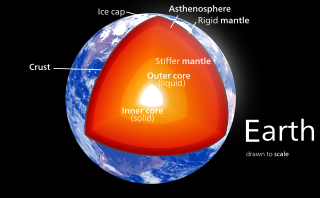
Earth's mantle is a layer of silicate rock between the crust and the outer core. It has a mass of 4.01×1024 kg (8.84×1024 lb) and makes up 67% of the mass of Earth. It has a thickness of 2,900 kilometers (1,800 mi) making up about 46% of Earth's radius and 84% of Earth's volume. It is predominantly solid but, on geologic time scales, it behaves as a viscous fluid, sometimes described as having the consistency of caramel. Partial melting of the mantle at mid-ocean ridges produces oceanic crust, and partial melting of the mantle at subduction zones produces continental crust.

A passive margin is the transition between oceanic and continental lithosphere that is not an active plate margin. A passive margin forms by sedimentation above an ancient rift, now marked by transitional lithosphere. Continental rifting forms new ocean basins. Eventually the continental rift forms a mid-ocean ridge and the locus of extension moves away from the continent-ocean boundary. The transition between the continental and oceanic lithosphere that was originally formed by rifting is known as a passive margin.

The Red Sea Rift is a mid-ocean ridge between two tectonic plates, the African Plate and the Arabian Plate. It extends from the Dead Sea Transform fault system, and ends at an intersection with the Aden Ridge and the East African Rift, forming the Afar Triple Junction in the Afar Depression of the Horn of Africa.

The Jan Mayen Microcontinent is a fragment of continental crust within the oceanic part of the western Eurasian Plate lying northeast of Iceland. At the onset of separation between the Greenland and Eurasian plates 55 million years ago, it formed part of the eastern margin of the Greenland Plate. Propagation of a new spreading center from the Reykjanes Ridge separated this microcontinent from the Greenland Plate. For a short period it formed a microplate, until the Aegir Ridge became inactive, after which it formed part of the Eurasian Plate. The island of Jan Mayen is a much younger feature, formed of volcanic rock, built up at the northernmost tip of the microcontinent.
Non-volcanic passive margins (NVPM) constitute one end member of the transitional crustal types that lie beneath passive continental margins; the other end member being volcanic passive margins (VPM). Transitional crust welds continental crust to oceanic crust along the lines of continental break-up. Both VPM and NVPM form during rifting, when a continent rifts to form a new ocean basin. NVPM are different from VPM because of a lack of volcanism. Instead of intrusive magmatic structures, the transitional crust is composed of stretched continental crust and exhumed upper mantle. NVPM are typically submerged and buried beneath thick sediments, so they must be studied using geophysical techniques or drilling. NVPM have diagnostic seismic, gravity, and magnetic characteristics that can be used to distinguish them from VPM and for demarcating the transition between continental and oceanic crust.
Volcanic passive margins (VPM) and non-volcanic passive margins are the two forms of transitional crust that lie beneath passive continental margins that occur on Earth as the result of the formation of ocean basins via continental rifting. Initiation of igneous processes associated with volcanic passive margins occurs before and/or during the rifting process depending on the cause of rifting. There are two accepted models for VPM formation: hotspots/mantle plumes and slab pull. Both result in large, quick lava flows over a relatively short period of geologic time. VPM's progress further as cooling and subsidence begins as the margins give way to formation of normal oceanic crust from the widening rifts.

Enderby Land is a region of Northeastern Antarctica which extends into the Southern Indian Ocean. The area is claimed by Australia as part of the Australian Antarctic Territory. The unique and diverse geological features of this region have been associated with the evolution and development of the supercontinent Gondwana. Multiple distinct geological formations are located in this region. The most prominent and important are the
- Napier Complex (Archaean)
- Rayner Complex (late-Proterozoic)
- Lützow-Holm Complex (LHC) (early-Paleozoic)
- Yamato–Belgica Complex (early-Paleozoic)

The offshore Indus Basin is one of the two basins in offshore Pakistan, the other one being the offshore Makran Basin. The Murray Ridge separates the two basins. The offshore Indus basin is approximately 120 to 140 kilometers wide and has an areal extent of ~20,000 square km.
The Tyrrhenian Basin is a sedimentary basin located in the western Mediterranean Sea under the Tyrrhenian Sea. It covers a 231,000 km2 area that is bounded by Sardinia to the west, Corsica to the northwest, Sicily to the southeast, and peninsular Italy to the northeast. The Tyrrhenian basin displays an irregular seafloor marked by several seamounts and two distinct sub-basins - the Vavilov and Marsili basins. The Vavilov deep plain contains the deepest point of the Tyrrhenian basin at approximately 3785 meters. The basin trends roughly northwest–southeast with the spreading axis trending northeast–southwest.

The Canadian Arctic Rift System is a major North American geological structure extending from the Labrador Sea in the southeast through Davis Strait, Baffin Bay and the Arctic Archipelago in the northwest. It consists of a series of interconnected rifts that formed during the Paleozoic, Mesozoic and Cenozoic eras. Extensional stresses along the entire length of the rift system have resulted in a variety of tectonic features, including grabens, half-grabens, basins and faults.
The upper mantle of Earth is a very thick layer of rock inside the planet, which begins just beneath the crust and ends at the top of the lower mantle at 670 km (420 mi). Temperatures range from approximately 500 K at the upper boundary with the crust to approximately 1,200 K at the boundary with the lower mantle. Upper mantle material that has come up onto the surface comprises about 55% olivine, 35% pyroxene, and 5 to 10% of calcium oxide and aluminum oxide minerals such as plagioclase, spinel, or garnet, depending upon depth.
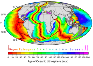
Marine geophysics is the scientific discipline that employs methods of geophysics to study the world's ocean basins and continental margins, particularly the solid earth beneath the ocean. It shares objectives with marine geology, which uses sedimentological, paleontological, and geochemical methods. Marine geophysical data analyses led to the theories of seafloor spreading and plate tectonics.
Seismic wide-angle reflection and refraction is a technique used in geophysical investigations of Earth's crust and upper mantle. It allows the development of a detailed model of seismic velocities beneath Earth's surface well beyond the reach of exploration boreholes. The velocities can then be used, often in combination with the interpretation of standard seismic reflection data and gravity data, to interpret the geology of the subsurface.
References
- ↑ Alvey, A.; Gaina, C.; Kusznir, N.J.; Torsvik, T.H. "Integrated crustal thickness mapping and plate reconstructions for the high Arctic". Earth and Planetary Science Letters. 274 (3–4): 310–321. doi:10.1016/j.epsl.2008.07.036.
- ↑ Reeve, M.T.; Magee, C.; Bastow, I.D.; McDermott, C.; Jackson, C.A.-L.; Bell, R.E.; Prytulak, J. (2021). "Nature of the Cuvier Abyssal Plain crust, offshore NW Australia". Journal of the Geological Society. 178 (5). doi:10.1144/jgs2020-172.
- ↑ Eagles, G.; Pérez-Díaz, L.; Scarselli, N. (2015). "Getting over continent ocean boundaries". Earth-Science Reviews. 151: 244–265. doi:10.1016/j.earscirev.2015.10.009.
- ↑ "Frontier Science and Exploration: The Atlantic – Arctic". NGU Geodynamics Group. Archived from the original on 2011-07-23. Retrieved 2008-04-20..