Contralmirante Villar | |
|---|---|
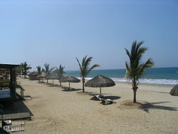 View of the beach in Punta Sal | |
 Location of Contralmirante Villar in the Tumbes Region | |
| Country | Peru |
| Region | Tumbes |
| Capital | Zorritos |
| Government | |
| • Mayor | Jesús Alberto Luna Ordinola |
| Area | |
• Total | 2,123.22 km2 (819.78 sq mi) |
| Elevation | 6 m (20 ft) |
| Population | |
• Total | 21,057 |
| • Density | 9.9175/km2 (25.686/sq mi) |
| UBIGEO | 2402 |
| Website | https://www.municvz.gob.pe/ |
Contralmirante Villar is a province of the Tumbes Region in Peru. Its capital is the town of Zorritos.
Contents
The Cerros de Amotape National Park is partially located in this province, which is the largest in the Tumbes Region. [1] [2]