Cook's Bay (Ontario)

Last updated
Cook's Bay
Canada Ontario relief location map.jpg
Red pog.svg
Cook's Bay
Lake Simcoe Ontario.png
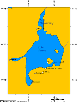
Cook's Bay is the southernmost bay in Lake Simcoe
Location Ontario, Canada
Coordinates 44°14′N79°30′W / 44.233°N 79.500°W / 44.233; -79.500 Coordinates: 44°14′N79°30′W / 44.233°N 79.500°W / 44.233; -79.500
Type bay
Etymology James Cook
Primary inflows Holland River
Maskinonge River
Settlements Keswick

Cook's Bay is the southernmost bay of Lake Simcoe in Ontario, Canada. Most of the southern part of the bay is within the jurisdiction of Georgina, a town in the Regional Municipality of York. Its western end is in Simcoe County, and a small portion from the mouth of the Holland River to the Simcoe County border is within Bradford West Gwillimbury. The largest community on the shores of the bay is Keswick.

It was named by John Graves Simcoe, the first Lieutenant-Governor of Upper Canada, for James Cook, who had served as master aboard HMS Pembroke in 1759 under the command of Captain John Simcoe, the Lieutenant-Governor's father.

The bay is used for fishing, and is especially known for yellow perch. It attracts windsurfers and kitesurfers throughout the year, and its northern end features many cottages that are part of Ontario's cottage country. Marinas and motel accommodations are available.


Related Research Articles

John Graves Simcoe British army officer

John Graves Simcoe was a British Army general and the first lieutenant governor of Upper Canada from 1791 until 1796 in southern Ontario and the watersheds of Georgian Bay and Lake Superior. He founded York and was instrumental in introducing institutions such as courts of law, trial by jury, English common law, and freehold land tenure, and also in the abolition of slavery in Canada.

Barrie City in Ontario, Canada

Barrie is a city and manifesting regional centre in Central Ontario, Canada, located on the shores of Kempenfelt Bay, the western arm of Lake Simcoe. The city is located geographically within Simcoe County, however it is a politically independent single-tier municipality. It is within the historically significant Huronia region of Central Ontario, and is part of the Greater Golden Horseshoe, a densely populated and industrialised sub-region of Ontario. As of the 2016 census, the city's population was 141,434 making it the 34th largest in Canada in terms of population proper. The Barrie census metropolitan area (CMA) as of the same census had a population of 197,059 residents, making it the 21st largest CMA in Canada. The city itself has seen significant growth in recent decades due to its emergence as a bedroom community for Toronto. The affordability of housing and robust job market perhaps contribute to a Toronto buyer's appeasement with Barrie. GO Transit offers daily service to and from the Greater Toronto Area from two stations in the city. Barrie is located 85 kilometres (53 mi) north of Toronto, 355 kilometres (221 mi) northeast of Detroit and 335 kilometres (208 mi) west of Ottawa. This represents the city's highly centralised and historically advantageous situation, providing an ease of access to major centres and airports across the region.

Orillia City in Ontario, Canada

Orillia is a city in Ontario, Canada. It is in Simcoe County between Lake Couchiching and Lake Simcoe. Although it is geographically located within Simcoe County, the city is a single-tier municipality. It is part of the Huronia region of Central Ontario. The population in 2016 was 31,166.

Lake Simcoe Lake in Ontario, Canada

Lake Simcoe is a lake in southern Ontario, Canada, the fourth-largest lake wholly in the province, after Lake Nipigon, Lac Seul, and Lake Nipissing. At the time of the first European contact in the 17th century the lake was called Ouentironk by the Wyandot (Huron) people. It was also known as Lake Taronto until it was renamed by John Graves Simcoe, the first Lieutenant-Governor of Upper Canada, in memory of his father, Captain John Simcoe, Royal Navy.

Yonge Street Road in Toronto spanning shores of Lake Ontario to Lake Simcoe

Yonge Street is a major arterial route in the Canadian province of Ontario connecting the shores of Lake Ontario in Toronto to Lake Simcoe, a gateway to the Upper Great Lakes. Until 1999, the Guinness Book of World Records repeated the popular misconception it was 1,896 km (1,178 mi) long, making it the longest street in the world; this was due to a conflation of Yonge Street with the rest of Ontario's Highway 11. Yonge Street is only 56 kilometres (35 mi) long.

Georgian Bay

Georgian Bay is a large bay of Lake Huron, in the Laurentia bioregion. It is located entirely within the borders of Ontario, Canada. The main body of the bay lies east of the Bruce Peninsula and Manitoulin Island. To its northwest is the North Channel.

Humber River (Ontario)

The Humber River is a river in Southern Ontario, Canada. It is in the Great Lakes Basin, is a tributary of Lake Ontario and is one of two major rivers on either side of the city of Toronto, the other being the Don River to the east. It was designated a Canadian Heritage River on September 24, 1999.

Midland, Ontario Town in Ontario, Canada

Midland is a town located on Georgian Bay in Simcoe County, Ontario, Canada. It is part of the Huronia/Wendat region of Central Ontario.

Simcoe, Ontario Unincorporated Community in Norfolk County in Ontario, Canada

Simcoe is an unincorporated community and former town in Southwestern Ontario, Canada near Lake Erie. It is the county seat and largest community of Norfolk County. Simcoe is at the junction of Highway 3, at Highway 24, due south of Brantford, and accessible to Hamilton by nearby Highway 6. This largest of the Communities in Norfolk County, Ontario had a population of 13,922 at the time of the 2016 Census.

Keswick, Ontario Unincorporated community in Ontario, Canada

Keswick (/ˈkɛzˌwɪk/) is a community located in the south central Canadian province of Ontario. Situated north of Toronto on Cook's Bay, Keswick is part of the Town of Georgina, the northernmost municipality in the Regional Municipality of York. In the Canada 2016 Census, the municipal population of Keswick was 26,757.

Simcoe County County in Ontario, Canada

Simcoe County is located in the central portion of Southern Ontario, Canada. The county is just north of the Greater Toronto Area, stretching from the shores of Lake Simcoe in the east to Georgian Bay in the west. Simcoe County forms part of the Greater Golden Horseshoe area, a densely populated and industrialized region, centred on the Greater Toronto Area.

Bradford, Ontario

Bradford is the primary country urban area of the Town of Bradford West Gwillimbury, Ontario, in Canada. It overlooks a farming community, known as The Holland Marsh, located on the Holland River that flows into Lake Simcoe.

Oro-Medonte Township in Ontario, Canada

Oro-Medonte is a township in south-central Ontario, Canada, on the northwestern shores of Lake Simcoe in Simcoe County.

Etobicoke Creek

Etobicoke Creek is a river in the Greater Toronto Area of Ontario, Canada. It is a tributary of Lake Ontario and runs from Caledon to southern Etobicoke, part of the City of Toronto. The creek is within the jurisdiction of the Toronto and Region Conservation Authority.

Central Ontario Secondary region in Ontario, Canada

Central Ontario is a secondary region of Southern Ontario in the Canadian province of Ontario that lies between Georgian Bay and the eastern end of Lake Ontario.

The Grey and Simcoe Foresters Regimental museum in Barrie, Ontario Canada

The Grey and Simcoe Foresters is a Primary Reserve infantry regiment of the Canadian Forces. Within the Canadian Army, it is part of the 4th Canadian Division's 31 Canadian Brigade Group. Due to the restructuring of the British Army, The Worcestershire and Sherwood Foresters Regiment was amalgamated into The Mercian Regiment, as its 2nd Battalion, leaving The Grey and Simcoe Foresters as the only remaining unit in the Commonwealth of Nations known to be distinctly designated as a regiment of Foresters.

Holland River River in Ontario, Canada

The Holland River is a river in Ontario, Canada, that drains the Holland River watershed into Cook's Bay, the southern extremity of Lake Simcoe. The river flows generally north, and its headwaters lie in the Oak Ridges Moraine. The Holland River watershed is approximately 600 square kilometres (230 sq mi), spanning an area that includes New Tecumseth, King Township, Newmarket, Aurora, East Gwillimbury, and Whitchurch-Stouffville. The river's watershed also contains the Holland Marsh, a fertile farmland region renowned for its vegetable production.

Kempenfelt Bay

Kempenfelt Bay is a 14.5 km (9.0 mi) long bay that leads into the Canadian city of Barrie, Ontario. It is as deep as 30 m (98 ft) in places, and is connected to the larger Lake Simcoe. It is known for its ice fishing and legends of Kempenfelt Kelly, a Loch Ness monster style prehistoric creature. Kempenfelt Bay is home each year to Kempenfest, an outdoor arts and crafts festival.

Georgian Triangle

The Georgian Triangle is the name of a geographic region in Southern Ontario containing the counties surrounding Georgian Bay, mostly Nottawasaga Bay, in particular. The main urban centres in the region are Collingwood, Owen Sound, and situated on Lake Simcoe Barrie and Orillia. Recreation and tourism are important parts of this area's economy, with cottages being one of the primary real estates along the coastline.

Ontario Highway 93

King's Highway 93, commonly referred to as Highway 93, is a provincially maintained highway in the Canadian province of Ontario. Located entirely within Simcoe County, the highway extends 23.9 kilometres (14.9 mi) from an interchange with Highway 400 in Springwater, just south of the community of Hillsdale, to an intersection with Highway 12 at the town limits of Midland. The route follows the historic Penetanguishene Road, an early colonization road which served to connect Lake Simcoe with Georgian Bay, thus providing an overland route from Lake Huron to Lake Ontario via Yonge Street.