The Mormon Trail is the 1,300-mile (2,092 km) route that members of The Church of Jesus Christ of Latter-day Saints traveled from 1846 to 1868. Today, the Mormon Trail is a part of the United States National Trails System, known as the Mormon Pioneer National Historic Trail.
The Battle of Cookes Canyon was a military engagement fought between settlers from Confederate Arizona and Chiricahua Apaches in August 1861. It occurred about 40 miles (64 km) northwest of Mesilla, in Cookes Canyon. The exact date of the battle is unknown. The battle occurred in the larger context of both the Apache Wars and the American Civil War.

Fort Cummings is a former U. S. Army post located near Cooke's Springs, in Luna County, New Mexico. It is located 20 miles northeast of Deming, New Mexico.
In the American Old West, overland trails were popular means of travel used by pioneers and immigrants throughout the 19th century and especially between 1830 and 1870 as an alternative to sea and railroad transport. These immigrants began to settle various regions of North America west of the Great Plains as part of the mass overland migrations of the mid-19th century. Settlers emigrating from the eastern United States were spurred by various motives, among them religious persecution, economic incentives, some people say that the interior to destinations in the far west, including the Oregon Trail, California Trail, and Mormon Trail. After the end of the Mexican–American War in 1849, vast new American conquests again enticed mass immigration. Legislation like the Donation Land Claim Act and significant events like the California Gold Rush further lured people to travel overland to the west.

Southern Emigrant Trail, also known as the Gila Trail, the Kearny Trail, Southern Trail and the Butterfield Stage Trail, was a major land route for immigration into California from the eastern United States that followed the Santa Fe Trail to New Mexico during the California Gold Rush. Unlike the more northern routes, pioneer wagons could travel year round, mountain passes not being blocked by snows, however it had the disadvantage of summer heat and lack of water in the desert regions through which it passed in New Mexico Territory and the Colorado Desert of California. Subsequently, it was a route of travel and commerce between the eastern United States and California. Many herds of cattle and sheep were driven along this route and it was followed by the San Antonio-San Diego Mail Line in 1857-1858 and then the Butterfield Overland Mail from 1858 - 1861.

Vallecito, in San Diego County, California is an oasis of cienegas and salt grass along Vallecito Creek and a former settlement on the edge of the Colorado Desert in the Vallecito Valley. Vallecito its Spanish name is translated as "little valley". Vallecito was located at the apex of the gap in the Carrizo Badlands created by Carrizo Creek and its wash in its lower reach, to which Vallecito Creek is a tributary. The springs of Vallecito like many in the vicinity are a product of the faults that run along the base of the Peninsular Ranges to the west.
Ojo de Vaca Station, was a Butterfield Overland Mail stagecoach station at Ojo de Vaca, in New Mexico Territory. It was located 14 mi (23 km) northeast of Soldiers Farewell Station and 16 mi (26 km) southwest of Miembre's River Station, later Mowry City, New Mexico. The site is now Cow Springs Ranch located in Luna County, New Mexico.
Carrizo Creek, is a stream that arises in the mountains of San Diego County, California, and terminates in Carrizo Wash in Imperial County, a tributary in turn to San Felipe Creek that terminates in the Salton Sea.
Cooke's Spring, or Cookes Spring, a spring in Luna County, New Mexico at an elevation of 4839 feet. Cooke's Spring is located at the eastern mouth of the narrow upper Cooke's Canyon, part of what was called Cooke's Pass, a narrow gap, running east and west, through the Cooke's Range.
Cooke's Spring Station, located near Cooke's Spring, New Mexico was a stage station of the Butterfield Overland Mail stage route from 1858 to 1861 and of subsequent stage lines until made obsolete by the arrival of the transcontinental railroad in New Mexico.
Cooke's Pass, also known as Massacre Canyon is a narrow gap running east and west through the Cookes Range. Its apex is a saddle, at an elevation of about 5100 feet between Fryingpan Canyon on the west and the narrow upper part of Cooke's Canyon west of Cooke's Spring. Cooke's Pass is just north of Massacre Peak.
San Simon River is an ephemeral river, or stream running through the San Simon Valley in Graham and Cochise County, Arizona and Hidalgo County, New Mexico. Its mouth is at its confluence with the Gila River at Safford in Graham County. Its source is located at 31°51′21″N109°01′27″W.
Stein's Pass, is a gap or mountain pass through the Peloncillo Mountains of Hidalgo County, New Mexico. The pass was named after United States Army Major Enoch Steen, who camped nearby in 1856, as he explored the recently acquired Gadsden Purchase. The pass is in the form of a canyon cut though the mountains through which Steins Creek flows to the west just west of the apex of the pass to the canyon mouth at 32°13′19″N109°01′48″W.
Cow Springs Ranch is a locale, located in Luna County, New Mexico. The ranch headquarters is located at Cow Springs, originally Ojo de Vaca.
Cienega of San Simon, was a cienega, an area of springs 13 miles up the San Simon River from San Simon Station, in Cochise County, Arizona.
Emigrant Pass, is a gap in the Nopah Range of Inyo County, California. It lies at an elevation of 2,884 feet (879 m) in the Nopah Range between Chicago Valley to the west and California Valley to the east.
Fosters Hole or La Tinaja, was a waterhole on the original route of Cooke's Wagon Road in what is now Sierra County, New Mexico. It is located in narrow crevasse at the foot of a cliff in Jug Canyon that is difficult to spot, except from a few vantage points.
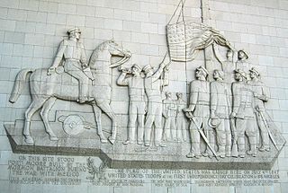
Cooke's Wagon Road or Cooke's Road was the first wagon road between the Rio Grande and the Colorado River to San Diego, through the Mexican provinces of Nuevo México, Chihuahua, Sonora and Alta California, established by Philip St. George Cooke and the Mormon Battalion, from October 19, 1846 to January 29, 1847 during the Mexican–American War. It became the first of the wagon routes between New Mexico and California that with subsequent modifications before and during the California Gold Rush eventually became known as the Southern Trail or Southern Emigrant Trail.
Mormon Road, also known to the 49ers as the Southern Route, of the California Trail, was a seasonal wagon road first pioneered by a Mormon party from Salt Lake City, Utah led by Jefferson Hunt, that followed the route of Spanish explorers and the Old Spanish Trail across southwestern Utah, northwestern Arizona, southern Nevada and the Mojave Desert of California to Los Angeles in 1847. From 1855, it became a military and commercial wagon route between California and Utah, called the Los Angeles - Salt Lake Road. In later decades this route was variously called the "Old Mormon Road", the "Old Southern Road", or the "Immigrant Road" in California. In Utah, Arizona and Nevada it was known as the "California Road".