Coracora

Last updated
Coracora
Qura Qura
Town
Ciudad de Cora Cora.jpg
Nickname: 
Coracora Tierra de Tradiciónes
Peru location map.svg
Red pog.svg
Coracora
Coordinates: 15°01′01.18″S73°46′49.51″W / 15.0169944°S 73.7804194°W / -15.0169944; -73.7804194
CountryFlag of Peru.svg  Peru
Region Ayacucho
Province Parinacochas
District Coracora
Government
  MayorAlfredo Lopez Gutierrez
Elevation
3,175 m (10,417 ft)
Time zone UTC-5 (PET)

Coracora or Qura Qura is a town in central Peru, and it is the capital of the Parinacochas Province in the Ayacucho Region. [1] It has a population of approximately 13,000. [2]

Contents

Etymology

Coracora or Qura Qura comes from the Quechuan qura meaning herbaceous plant, [3] the reduplication of the syllable indicates that there is a group or a complex of something, "a complex of herbaceous plants".

Geography

Coracora is located 800 km from Lima, Peru at an altitude between 3,150 and 3,350 meters above sea level, known as the Quechua ecological region. [4] The city of Coracora is the capital of the Parinacochas Province. It forms part of the department of Ayacucho and is located in the southwestern region of Peru. The districts that form the Parinacochas Province are: Coracora, Upahuacho, Pacapauza, Rivacayco, Chumpi, Incuyo, Pullo and Anizo.

Climate

The winter season between June and September has frequent frosts, and the temperate and very rainy summer falls between December and March.

Climate data for Coracora, elevation 3,149 m (10,331 ft), (1991–2020)
MonthJanFebMarAprMayJunJulAugSepOctNovDecYear
Mean daily maximum °C (°F)18.2
(64.8)
17.6
(63.7)
17.6
(63.7)
18.6
(65.5)
18.9
(66.0)
18.9
(66.0)
18.7
(65.7)
19.3
(66.7)
19.9
(67.8)
20.0
(68.0)
19.8
(67.6)
19.3
(66.7)
18.9
(66.0)
Mean daily minimum °C (°F)7.0
(44.6)
7.2
(45.0)
6.9
(44.4)
5.9
(42.6)
4.4
(39.9)
4.0
(39.2)
3.7
(38.7)
4.3
(39.7)
5.0
(41.0)
5.4
(41.7)
5.5
(41.9)
6.5
(43.7)
5.5
(41.9)
Average precipitation mm (inches)111.5
(4.39)
136.6
(5.38)
94.4
(3.72)
24.3
(0.96)
1.4
(0.06)
0.4
(0.02)
2.0
(0.08)
2.0
(0.08)
3.4
(0.13)
5.0
(0.20)
6.6
(0.26)
28.7
(1.13)
416.3
(16.41)
Source: National Meteorology and Hydrology Service of Peru [5]

History

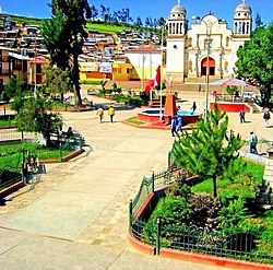
Founded by Spanish conquerors in the 17th century, Coracora developed on what was then the road between Lima and Cusco. Its old colonial buildings, such as the beautiful local church in the Baroque and styles were built of white ashlar.

During the 19th and 20th centuries Coracora became a flourishing Peruvian south mountain city thanks to cattle ranching.

Around the 1940s, Coracora reached an uncommon cultural and economic peak for a small city in mountainous Peru. This prosperity began to fluctuate in the 1980s due to the social violence of those years in Peru.

As of modern times, it has recovered its character as a ranching, commercial and tourist center, with significant improvements to roads, infrastructure, and services.

Festivities

From August 1 to August 8, Coracora celebrates La Virgen de Las Nieves, known as "Virgin of the Snow".

August 1: People prepare for the festivities and cook food for the entire family.

August 2: People walk to Pumahuiri (the mountain where the Virgin of the Snow was found). They sing and dance as they walk. The songs are usually prayers.

August 3: It is the "Entrada de Negritos" (Entrance of the Blacks). Children walk into town singing and dancing and people follow them as they did on their way to Pumahuiri.

August 4: "Entrada de Chamiza" (Entrance of retama). They plants are brought in on donkeys and llamas. At night, people burn the dry plant and dance around the fires to the rhythm of live music that plays all night. The same night, they have Los Castillos, or fireworks on wood, in the main plaza, Plaza de Armas. They also have serenades with people dancing and singing.

August 5: It is the main day of the festivities. The townspeople walk around the main plaza where the church is located.

August 6 to August 8: The city goes to the bullring. Each family pays for itsown place. Every square foot is worth $200.00.[ citation needed ] People buy bulls in honor of Our Lady of the Snows and the offering estimates the person (compadres). It is somewhat like a donation. If the bull does not die, the person who bought it and the person receiving it enter the bullring. People dressed in red lead a team of bulls.

Each year, a person must sign up to be in charge of the town festival on August 5.

Virgen de Las Nieves

Spaniards were bringing a statue of the Virgin from Lima to Cuzco, but along the way, they stopped at Pumawiri. [6] Pumahuiri was a long and very tiring mountain, so they stopped and rested. But one man dreamed of the Virgin of the Snow, who told him she wanted to stay in Coracora, not go to Cuzco. [7] That town was Coracora. When the man awoke, he told his fellows about his dream. They believed what he had dreamed, so they went down the mountain and took the Virgin to Coracora.

Notable people

Related Research Articles

<span class="mw-page-title-main">Ayacucho</span> City in Peru

Ayacucho, founded in 1540 as San Juan de la Frontera de Huamanga and known simply as Huamanga until 1825, is the capital city of Ayacucho Region and of Huamanga Province, Ayacucho Region, Peru.

The administrative divisions of Peru have changed from time to time since the nation gained independence from Spain in the early 19th century. The old territorial subdivisions have split or merged due to several reasons, the most common ones being the need for decentralization and population increase, especially in Lima.

<span class="mw-page-title-main">San Vicente de Cañete</span> Place in Lima, Peru

San Vicente de Cañete, commonly known as San Vicente or Cañete, is a city and capital of the Cañete Province, in southern Lima Region. With a population of 85,533.

<span class="mw-page-title-main">San Miguel District, Lima</span> District in Lima, Peru

San Miguel is one of the 43 districts that are part of the Lima province and of the urban area of Lima, Peru. It is bordered by the districts of Bellavista and downtown Lima on the north; Pueblo Libre, Magdalena del Mar and downtown Lima on the east; the Pacific Ocean on the south; and the La Perla district on the west.

<span class="mw-page-title-main">Peruvians</span> People identified with the country of Peru

Peruvians are the citizens of Peru. What is now Peru has been inhabited for several millennia by cultures such as the Caral before the Spanish conquest in the 16th century. Peruvian population decreased from an estimated 5–9 million in the 1520s to around 600,000 in 1620 mainly because of infectious diseases carried by the Spanish. Spaniards and Africans arrived in large numbers in 1532 under colonial rule, mixing widely with each other and with Native Peruvians. During the Republic, there has been a gradual immigration of European people. Chinese and Japanese arrived in large numbers at the end of the 19th century.

<span class="mw-page-title-main">Chiquián District</span> District in Ancash, Peru

Chiquián is a district of the province of Bolognesi, in the Ancash Region of Peru.

Coracora District is one of eight districts of the Parinacochas Province in Peru.

<span class="mw-page-title-main">Puyusca District</span> District in Ayacucho, Peru

Puyusca is one of eight districts of the Parinacochas Province in Peru.

Pullo District is one of eight districts of the province Parinacochas in Peru.

Coronel Castañeda District is one of eight districts of the Parinacochas Province in Peru.

Chumpi District is one of eight districts of the Parinacochas Province in Peru.

Santa Rosa District is one of five districts of the province El Collao in Puno Region, Peru.

<span class="mw-page-title-main">Antioquia District</span> District in Lima, Peru

Antioquia District is one of thirty-two districts of the province Huarochirí in Peru.

<span class="mw-page-title-main">Chinchaypujio District</span> District in Cusco, Peru

Chinchaypujio is one of nine districts of the Anta Province in Peru and about 2 hours outside of Cusco. Its capital, Chinchaypujio, hosts a weekly market (Mercado Ferial de Chinchaypujio) as well as the regional government. The district is home to 9 communities: Chinchaypujio, Ocra, Paucarccoto, Parcotica, Waccahualla, Huancancalla, Sumaru, Pantipata and Huamumayo. In its southernmost part, the Apurímac River crosses the district; a major trade road connecting the Cuzco Department with the Department of Apurímac crosses through the entire district from north to south.

<span class="mw-page-title-main">Paucartambo District, Paucartambo</span> District in Cusco, Peru

Paucartambo is one of six districts of the Paucartambo Province in Peru.

Caylloma District is one of twenty districts of the province Caylloma in Peru.

<span class="mw-page-title-main">Huanta</span> Town in Ayacucho, Peru

Huanta is a town in Central Peru, capital of the province Huanta in the region Ayacucho.

<span class="mw-page-title-main">Lake Parinacochas</span> Lake in the Ayacucho Region in Peru

Lake Parinacochas is a lake in Ayacucho Region in Peru. It is located west of Sara Sara volcano at an elevation of 3,272 metres (10,735 ft) above sea level. The lake is 12 km long and 9 km wide, and has a catchment area of 606.5 square kilometres (234 sq mi).

Wachwani is a mountain in the Andes of Peru, about 4,600 m (15,092 ft) high. It is situated in the Ayacucho Region, Parinacochas Province, Coracora District.

Pedro Mas was a brigadier general of the Peruvian Army and a controversial politician who served as prefect of the departments of Cuzco, Junín, Ayacucho and Ica. During his tenure in Cuzco, he was ousted during the Peruvian Civil War of 1894–1895, fleeing to La Paz.

References

  1. (in Spanish) Instituto Nacional de Estadística e Informática. Banco de Información Digital Archived April 23, 2008, at the Wayback Machine , Retrieved June 10, 2008
  2. "INSTITUTO NACIONAL DE ESTADÍSTICA E INFORMÁTICA: AYACUCHO" (PDF). Instituto Nacional de Estadistica e Informatica de Peru. October 2018. Archived (PDF) from the original on 2019-11-16. Retrieved 23 November 2021.
  3. Teofilo Laime Ajacopa, Diccionario Bilingüe Iskay simipi yuyayk'ancha, La Paz, 2007 (Quechua-Spanish dictionary)
  4. "Coracora en la region de Ayacucho - Municipio y municipalidad de Perú". www.distrito.pe. Retrieved 2021-11-24.
  5. "Normales Climaticás Estándares y Medias 1991-2020". National Meteorology and Hydrology Service of Peru. Archived from the original on 21 August 2023. Retrieved 6 November 2023.
  6. Garcia Rivas, Alida Jesus (2019). "Impacto del turismo en el patrimonio inmaterial religioso. Caso "Festividad de las Virgen de las Nieves de Coracora - Ayacucho - 2017"". Universidad de San Martín de Porres - USMP.
  7. Martínez Parra, Reynaldo (1999). Tradición y leyenda de la Virgen de las Nieves: (patrona de Coracora)[Tradition and Legend of the Virgin of the Snows: (patron saint of Coracora)]. Texas: University of Texas.

15°01′01.18″S73°46′49.51″W / 15.0169944°S 73.7804194°W / -15.0169944; -73.7804194