Coral Coast, Western Australia

Last updated

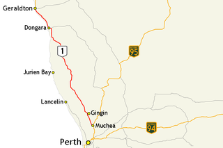
Coral Coast is a tourism promotion name for the coastal region along Western Australias mid western coastline between Cervantes and Exmouth. [1]

Western Australia state in Australia

Western Australia is a state occupying the entire western third of Australia. It is bounded by the Indian Ocean to the north and west, and the Southern Ocean to the south, the Northern Territory to the north-east, and South Australia to the south-east. Western Australia is Australia's largest state, with a total land area of 2,529,875 square kilometres, and the second-largest country subdivision in the world, surpassed only by Russia's Sakha Republic. The state has about 2.6 million inhabitants – around 11 percent of the national total – of whom the vast majority live in the south-west corner, 79 per cent of the population living in the Perth area, leaving the remainder of the state sparsely populated.

Cervantes, Western Australia Town in Western Australia

Cervantes is a town in Western Australia off Indian Ocean Drive about 198 kilometres (123 mi) north-north-west of the state capital, Perth in the Shire of Dandaragan local government area. At the 2011 census, Cervantes had a population of 467. The town was named after a ship that was wrecked nearby. The ship, in turn, was named after Miguel de Cervantes, author of Don Quixote.

Exmouth, Western Australia Town in Western Australia

Exmouth is a town on the tip of the North West Cape in Western Australia. The town is located 1,270 kilometres (789 mi) north of the state capital Perth and 3,366 kilometres (2,092 mi) southwest of Darwin.

It is named because of its unusual coral formations so far south, however the specific coastal area has been given other names as well over time.

Coral Marine invertebrates of the class Anthozoa

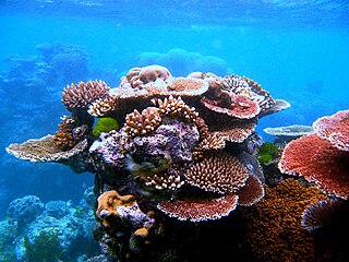
Corals are marine invertebrates within the class Anthozoa of the phylum Cnidaria. They typically live in compact colonies of many identical individual polyps. Corals species include the important reef builders that inhabit tropical oceans and secrete calcium carbonate to form a hard skeleton.

At earlier stages, sections of the coastal region have had separate "brands", the coast near Geraldton being known as the Batavia Coast, and south of Geraldton known as the Turquoise Coast, however these brands are not part of current tourism promotion schemes.

Batavia Coast

Batavia Coast is a name attributed to a section of the coastline of Western Australia, in the region close to the vicinity of the site of the wreck of the Batavia in the Abrolhos Islands.

Turquoise Coast (Western Australia)

Turquoise Coast is a name attributed to a section of the coastline of Western Australia in the vicinity of Jurien Bay.

The Sunset Coast brand of the northern beach areas of metropolitan Perth is still current.

Sunset Coast

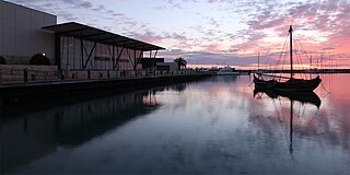
Sunset Coast is the name given by Tourism Western Australia to the coastal section of the northern metropolitan area of Perth, the capital city of Western Australia, and is one of the six component tourism precincts of the Perth region. While not in extensive use locally, since the 1990s it has been a centrepiece of Western Australian tourism planning and is used in interstate and overseas marketing of the region. The region contains many white sand beaches.

Perth City in Western Australia

Perth is the capital and largest city of the Australian state of Western Australia. It is named after the city of Perth, Scotland and is the fourth-most populous city in Australia, with a population of 2.04 million living in Greater Perth. Perth is part of the South West Land Division of Western Australia, with the majority of the metropolitan area located on the Swan Coastal Plain, a narrow strip between the Indian Ocean and the Darling Scarp. The first areas settled were on the Swan River at Guildford, with the city's central business district and port (Fremantle) both later founded downriver.

See also

Related Research Articles

Geraldton City in Western Australia

Geraldton is a coastal city in the Mid West region of Western Australia, 424 kilometres (263 mi) north of Perth.

Western Australia is divided into regions according to a number of systems.

Mid West (Western Australia) Region in Western Australia

The Mid West region is one of the nine regions of Western Australia. It is a sparsely populated region extending from the west coast of Western Australia, about 200 kilometres (120 mi) north and south of its administrative centre of Geraldton and inland to 450 kilometres (280 mi) east of Wiluna in the Gibson Desert.

Wheatbelt (Western Australia) region in Western Australia

The Wheatbelt is one of nine regions of Western Australia defined as administrative areas for the state's regional development, and a vernacular term for the area converted to agriculture during colonisation. It partially surrounds the Perth metropolitan area, extending north from Perth to the Mid West region, and east to the Goldfields-Esperance region. It is bordered to the south by the South West and Great Southern regions, and to the west by the Indian Ocean, the Perth metropolitan area, and the Peel region. Altogether, it has an area of 154,862 square kilometres (59,793 sq mi).

Brand Highway highway in Western Australia

Brand Highway is a 370-kilometre (230 mi) main highway linking the northern outskirts of Perth, the capital of Western Australia, to the port city of Geraldton in Western Australia's Mid West region. Together with North West Coastal Highway, it forms part of the Western Australian coastal link to the Northern Territory. The highway is a part of Australia's Highway 1, and is for the most part a single carriageway with one lane in each direction.

North West Coastal Highway highway in Western Australia

North West Coastal Highway is a generally north-south Western Australian highway which links the coastal city of Geraldton with the town of Port Hedland. The 1,300-kilometre-long (808 mi) road, constructed as a sealed two-lane single carriageway, travels through remote and largely arid landscapes. Carnarvon is the only large settlement on the highway, and is an oasis within the harsh surrounding environment. The entire highway is allocated National Route 1, part of Australia's Highway 1, and parts of the highway are included in tourist routes Batavia Coast Tourist Way and Cossack Tourist Way. Economically, North West Coastal Highway is an important link to the Mid West, Gascoyne and Pilbara regions, supporting the agricultural, pastoral, fishing, and tourism industries, as well as mining and offshore oil and gas production.

Ningaloo Coast coral reef in Western Australia

The Ningaloo Coast is a World Heritage Site located in the north west coastal region of Western Australia. The 705,015-hectare (1,742,130-acre) heritage-listed area is located approximately 1,200 kilometres (750 mi) north of Perth, along the East Indian Ocean. The distinctive Ningaloo Reef that fringes the Ningaloo Coast is 260 kilometres (160 mi) long and is Australia's largest fringing coral reef and the only large reef positioned very close to a landmass.

The Greenough River is a river in the Mid West region of Western Australia.

Tarcoola Beach is a southern coastal suburb of Geraldton, Western Australia. Its local government area is the City of Greater Geraldton.

Shire of Northampton Local government area in Western Australia

The Shire of Northampton is a local government area in the Mid West region of Western Australia, about 50 kilometres (30 mi) north of Geraldton and about 460 kilometres (290 mi) north of the state capital, Perth. The Shire covers an area of 13,738 square kilometres (5,304 sq mi), and its seat of government is the town of Northampton, with the largest settlement being Kalbarri.

Beresford is a northern coastal suburb of Geraldton, Western Australia. Its local government area is the City of Greater Geraldton.

Bluff Point is a northern coastal suburb of Geraldton, Western Australia. Its local government area is the City of Greater Geraldton.

Cape Burney, Western Australia Suburb of Geraldton, Western Australia

Cape Burney is a coastal town and locality 12 kilometres (7 mi) south of Geraldton, Western Australia at the mouth of the Greenough River. Its local government area is the City of Greater Geraldton. At the 2006 census, Cape Burney had a population of 399.

Mahomets Flats is an inner southern coastal suburb of Geraldton, Western Australia in the local government area of the City of Greater Geraldton.

Mount Tarcoola is a southern suburb of Geraldton, Western Australia. Its local government area is the City of Greater Geraldton.

Coastal regions of Western Australia

Western Australia has the longest coastline of any state or territory in Australia, at 10,194 km or 12,889 km. It is a significant portion of the coastline of Australia, which is 35,877 km.

The Buller River is a river in the Mid West of Western Australia, near Geraldton.

Main Roads Western Australia controls the major roads in the state's Mid West region. There are four main highways through the Mid West: The north-south coastal route of Brand Highway and North West Coastal Highway, the inland alternative Great Northern Highway, and the northern section of Goldfields Highway, which links Meekatharra with Kalgoorlie. A network of main roads connects towns within the Mid West to each other, the highways, and neighbouring regions, with local roads providing additional links and access to smaller townsites. Roads are often named after the towns they connect.

Main Roads Western Australia controls the major roads in the state's Gascoyne region. North West Coastal Highway, a north-south route near the coastline, is the main highway the region. A series of main roads connect coastal towns to the highway, and local roads provide additional links and access to the inland portion of the region. Roads are often named after the towns or areas they connect.

Balline Station

Balline Station is a pastoral lease that operates as a sheep station in Western Australia.

References

Coordinates: 27°42′S114°12′E / 27.7°S 114.2°E / -27.7; 114.2

Geographic coordinate system Coordinate system

A geographic coordinate system is a coordinate system that enables every location on Earth to be specified by a set of numbers, letters or symbols. The coordinates are often chosen such that one of the numbers represents a vertical position and two or three of the numbers represent a horizontal position; alternatively, a geographic position may be expressed in a combined three-dimensional Cartesian vector. A common choice of coordinates is latitude, longitude and elevation. To specify a location on a plane requires a map projection.