
Navigation is a field of study that focuses on the process of monitoring and controlling the movement of a craft or vehicle from one place to another. The field of navigation includes four general categories: land navigation, marine navigation, aeronautic navigation, and space navigation.
The Beaufort scale is an empirical measure that relates wind speed to observed conditions at sea or on land. Its full name is the Beaufort wind force scale.
Piloting or pilotage is the process of navigating on water or in the air using fixed points of reference on the sea or on land, usually with reference to a nautical chart or aeronautical chart to obtain a fix of the position of the vessel or aircraft with respect to a desired course or location. Horizontal fixes of position from known reference points may be obtained by sight or by radar. Vertical position may be obtained by depth sounder to determine depth of the water body below a vessel or by altimeter to determine an aircraft's altitude, from which its distance above the ground can be deduced. Piloting a vessel is usually practiced close to shore or on inland waterways. Pilotage of an aircraft is practiced under visual meteorological conditions for flight.
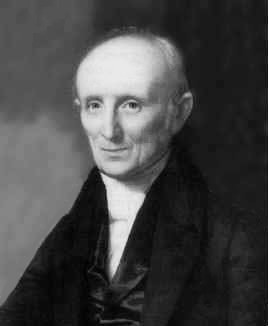
Nathaniel Bowditch was an early American mathematician remembered for his work on ocean navigation. He is often credited as the founder of modern maritime navigation; his book The New American Practical Navigator, first published in 1802, is still carried on board every commissioned U.S. Naval vessel. In 2001, an elementary and middle school in Salem was named in his honor.

Drift ice, also called brash ice, is sea ice that is not attached to the shoreline or any other fixed object. Unlike fast ice, which is "fastened" to a fixed object, drift ice is carried along by winds and sea currents, hence its name. When drift ice is driven together into a large single mass, it is called pack ice. Wind and currents can pile up that ice to form ridges up to dozens of metres in thickness. These represent a challenge for icebreakers and offshore structures operating in cold oceans and seas.

In meteorology, Buys Ballot's law may be expressed as follows: In the Northern Hemisphere, if a person stands with their back to the wind, the atmospheric pressure is low to the left, high to the right. This is because wind travels counterclockwise around low pressure zones in the Northern Hemisphere. It is approximately true in the higher latitudes of the Northern Hemisphere, and is reversed in the Southern Hemisphere, but the angle between the pressure gradient force and wind is not a right angle in low latitudes.
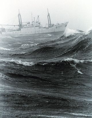
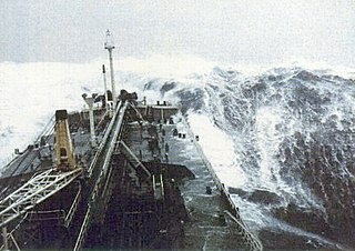
In oceanography, sea state is the general condition of the free surface on a large body of water—with respect to wind waves and swell—at a certain location and moment. A sea state is characterized by statistics, including the wave height, period, and spectrum. The sea state varies with time, as the wind and swell conditions change. The sea state can be assessed either by an experienced observer or by using instruments like weather buoys, wave radar or remote sensing satellites.

A cross sea is a sea state of wind-generated ocean waves that form nonparallel wave systems. Cross seas have a large amount of directional spreading. This may occur when water waves from one weather system continue despite a shift in wind. Waves generated by the new wind run at an angle to the old.

A day beacon is an unlighted nautical sea mark. A signboard identifying it is called a day mark. Day beacons typically mark channels whose key points are marked by lighted buoys. They may also mark smaller navigable routes in their entirety. They are the most common navigation aid in shallow water, as they are relatively inexpensive to install and maintain. Navigation around them is similar to that around other navigation aids.

In celestial navigation, lunar distance, also called a lunar, is the angular distance between the Moon and another celestial body. The lunar distances method uses this angle and a nautical almanac to calculate Greenwich time if so desired, or by extension any other time. That calculated time can be used in solving a spherical triangle. The theory was first published by Johannes Werner in 1524, before the necessary almanacs had been published. A fuller method was published in 1763 and used until about 1850 when it was superseded by the marine chronometer. A similar method uses the positions of the Galilean moons of Jupiter.

The American Practical Navigator, originally written by Nathaniel Bowditch, is an encyclopedia of navigation. It serves as a valuable handbook on oceanography and meteorology, and contains useful tables and a maritime glossary. In 1867 the copyright and plates were bought by the Hydrographic Office of the United States Navy. As of 2019 it is still published by the U.S. Government and is available free online from the National Geospatial-Intelligence Agency (NGA), the modern successor agency to the 19th Century Hydrographic Office. The publication is considered one of America's nautical institutions.

Sailing Directions are written directions that describe the routes to be taken by boats and ships during coastal navigation and port approaches. There are also products known as Sailing Directions, which are books written by various Hydrographic Offices throughout the world. They are known as Pilot Books, because they provide local knowledge of routes and landmarks, which would typically be provided by a local marine pilot. As such, they are used frequently by naval and government vessels, who are exempted from 'Compulsory Pilotage' in many ports.

Distances Between Ports is a publication that lists the distances between major ports. Reciprocal distances between two ports may differ due to the different routes of currents and climatic conditions chosen. To reduce the number of listings needed, junction points along major routes are used to consolidate routes converging from different directions.

Radar navigation is the utilization of marine and aviation radar systems for vessel and aircraft navigation. When a craft is within radar range of land or special radar aids to navigation, the navigator can take distances and angular bearings to charted objects and use these to establish arcs of position and lines of position on a chart. A fix consisting of only radar information is called a radar fix.

The Radio Navigational Aids publication contains a detailed list of selected worldwide radio stations that provide services to the mariner. The publication is divided into chapters according to the nature of the service provided by the radio stations. The services include Radio direction finder and Radar Stations; stations broadcasting navigational warnings, time signals or medical advice; communication traffic for distress, emergency and safety including the Global Maritime Distress Safety System (GMDSS) and long range navigational aids. It also contains chapters describing procedures of the AMVER System, and the interim emergency procedures and communication instructions to be followed by U.S merchant vessels in times of crisis. A new edition of Publication 117 is published annually. This publication is available in its entirety on the website and there are also database queries available for much of the data contained within.

A linear scale, also called a bar scale, scale bar, graphic scale, or graphical scale, is a means of visually showing the scale of a map, nautical chart, engineering drawing, or architectural drawing. A scale bar is common element of map layouts.
Bowditch Crests is a line of precipitous cliffs surmounted by four summits on Bermel Peninsula in eastern Graham Land. The feature was photographed from the air by Lincoln Ellsworth in November 1935 and was mapped from these photos by W.L.G. Joerg. It was surveyed by the Falkland Islands Dependencies Survey in 1958, and named by the UK Antarctic Place-Names Committee for Nathaniel Bowditch, American astronomer and mathematician, author of The New American Practical Navigator (1801) which firmly set out the practical results of theories established at that date and has since gone through more than 56 editions.
The bar of a mature tropical cyclone is a very dark gray-black layer of cloud that appears to be near to the horizon as seen from an observer preceding the approach of the storm, and is composed primarily of dense stratocumulus clouds. Cumulus and cumulonimbus clouds bearing precipitation follow immediately after the passage of the wall-like bar. Altostratus, cirrostratus and cirrus clouds are usually visible in ascending order above the top of the bar, while the wind direction for an observer facing toward the bar is typically from the left and slightly behind the observer.
Communication, navigation and surveillance (CNS) are the main functions that form the infrastructure for air traffic management, and ensure that air traffic is safe and efficient.
