Corinth (municipality)

Last updated
Municipality of Corinth
Δήμος Κορινθίων
Greece location map.svg
Red pog.svg
Municipality of Corinth
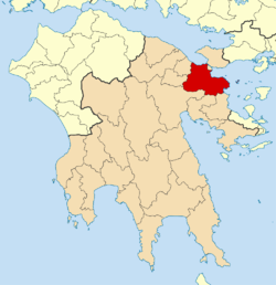
Location within the region
2011 Dimos Korinthion.png
Coordinates: 37°56′N22°56′E / 37.933°N 22.933°E / 37.933; 22.933
Country Greece
Administrative region Peloponnese
Regional unit Corinthia
City established1858
Municipality established2011 (enlarged)
Government
  MayorNikolaos Stavrelis [1] (since 2023)
Area
  Municipality611.29 km2 (236.02 sq mi)
Population
 (2021) [2]
  Municipality55,941
  Density92/km2 (240/sq mi)
Time zone UTC+2 (EET)
  Summer (DST) UTC+3 (EEST)
Website www.korinthos.gr

The municipality of Corinth is a Greek municipality located in the Peleponnese region established on 1 January 2011 under the Kallikratis Plan for local government reform. The municipality is made up of five previous municipalities: Assos-Lechaio, Corinth, Saronikos, Tenea and Solygeia. [3] The area of the new municipality is 611.29 square kilometers [4] and it has a population of 55,641, based on the 2021 census. The seat of the municipality is Corinth and its symbol is the Pegasus.

Sources

  1. Municipality of Corinth, Municipal elections – October 2023, Ministry of Interior
  2. "Αποτελέσματα Απογραφής Πληθυσμού - Κατοικιών 2021, Μόνιμος Πληθυσμός κατά οικισμό" [Results of the 2021 Population - Housing Census, Permanent population by settlement] (in Greek). Hellenic Statistical Authority. 29 March 2024.
  3. "ΦΕΚ A 87/2010, Kallikratis reform law text" (in Greek). Government Gazette.
  4. "Population & housing census 2001 (incl. area and average elevation)" (PDF) (in Greek). National Statistical Service of Greece. Archived from the original (PDF) on 2015-09-21.

Related Research Articles

<span class="mw-page-title-main">Xylokastro</span> Municipal unit in Greece

Xylokastro is a seaside town or village and a former municipality in Corinthia in the Peloponnese, Greece. Since the 2011 local government reform it is part of the municipality Xylokastro-Evrostina, of which it is a unit or component. The municipal unit has an area of 310.252 km2.

<span class="mw-page-title-main">Agioi Theodoroi</span> Municipal unit in Greece

Agioi Theodoroi is a town and a former municipality in Corinthia, Peloponnese, Greece. Since the 2011 local government reform, it is part of the municipality Loutraki-Perachora-Agioi Theodoroi, of which it is a municipal unit. The municipal unit has an area of 98.030 km2.

<span class="mw-page-title-main">Velo, Greece</span> Municipal unit in Greece

Velo is a town and a former municipality in Corinthia, Peloponnese, Greece. Since the 2011 local government reform it is part of the municipality Velo-Vocha, of which it is a municipal unit. The municipal unit has an area of 76.952 km2. It is situated on the Gulf of Corinth coast, about 15 km west from Corinth, and 5 km southeast of Kiato. Greek National Road 8, the old Corinth-Patras highway, passes through the town.

<span class="mw-page-title-main">Antirrio</span> Municipal unit in Greece

Antirrio is a town and a former municipality in Aetolia-Acarnania, West Greece, Greece. Since the 2011 local government reform it is part of the municipality Nafpaktia, of which it is a municipal unit. The municipal unit has an area of 50.794 km2.

<span class="mw-page-title-main">Mykines, Greece</span> Municipal unit in Greece

Mykines, known before 1916 as Charvati (Χαρβάτι), is a village and a former municipality in Argolis, Peloponnese, Greece. Since the 2011 local government reform it is part of the municipality Argos-Mykines, of which it is a municipal unit. The municipal unit has an area of 159.033 km2. It is located 1 km west of the ancient site of Mycenae and 2 km east of the highway linking Argos and Corinth. It is 9 km north of Argos.

<span class="mw-page-title-main">Evrostina</span> Municipal unit in Greece

Evrostina is a village and a former municipality in Corinthia, Peloponnese, Greece. Since the 2011 local government reform it is part of the municipality Xylokastro-Evrostina, of which it is a municipal unit. The municipal unit has an area of 101.415 km2. The seat of administration of the former municipality was the town Derveni.

<span class="mw-page-title-main">Corinthia</span> Regional unit in Greece

Corinthia is one of the regional units of Greece. It is part of the region of Peloponnese. It is situated around the city of Corinth, in the north-eastern part of the Peloponnese peninsula.

<span class="mw-page-title-main">Itea, Phocis</span> Municipal unit in Greece

Itea, is a town and a former municipality in the southeastern part of Phocis, Greece. Since 2011 local government reforms made Iteas a municipal unit of the municipality of Delphi.

<span class="mw-page-title-main">Erineos</span> Municipal unit in Greece

Erineos is a former municipality in Achaea, West Greece, Greece. Since the 2011 local government reform it is part of the municipality Aigialeia, of which it is a municipal unit. The municipal unit has an area of 98.710 km2. Its seat of administration was in the village of Lampiri. Erineos stretches between the northeastern slopes of the Panachaiko mountain and the Gulf of Corinth. The river Foinikas (Phoenix) flows through the municipality. The Greek National Road 8A and the railway from Patras to Corinth run through the municipal unit. It is located about 10 km west of Aigio.

<span class="mw-page-title-main">Akrata</span> Municipal unit in Greece

Akrata, is a town and a former municipality in Achaea, West Greece, Greece. Since the 2011 local government reform it is part of the municipality Aigialeia, of which it is a municipal unit. The municipal unit has an area of 180.169 km2. Akrata is located on the right bank of the river Krathis, 3 km from its outflow into the Gulf of Corinth. The Greek National Road 8A/E65 and the railway from Patras to Corinth pass through the municipal unit, northeast of the town. The nearest town is Aigeira, 4 km to the east. It is 23 km southeast of Aigio, 52 km east of Patras and 23 km northeast of Kalavryta.

<span class="mw-page-title-main">Loutraki-Perachora</span> Municipal unit in Greece

Loutraki-Perachora is a former municipality in Corinthia, Peloponnese, Greece. Since the 2011 local governmental reform it is part of the municipality Loutraki-Perachora-Agioi Theodoroi, of which it is a municipal unit. The municipal unit has an area of 196.870 km2.

<span class="mw-page-title-main">Vilia</span> Municipal unit in Greece

Vilia is a village and a former municipality of West Attica, Greece. Since the 2011 local government reform it is part of the municipality Mandra-Eidyllia, of which it is a municipal unit. Its population was 2,514 at the 2021 census. It is part of Athens metropolitan area. The inhabitants of Vilia are Arvanites.

<span class="mw-page-title-main">Diakopto</span> Municipal unit in Greece

Diakopto is a coastal town in Achaea, West Greece, Greece. Since the 2011 local government reforms it is a municipal unit of the Aigialeia municipality. The municipal unit has an area of 103.932 km2. The town of Diakopto is situated on the Gulf of Corinth, near the mouth of the Vouraikos river and at the lower end of the Vouraikos Gorge. The 750 mm gauge Diakofto–Kalavryta Railway built in 1885 leads up to the town of Kalavryta passing the Mega Spilaio Monastery at about halfway. Diakopto is on the old Greek National Road 8 ; the new Greek National Road 8A passes 1 km to the south. Diakopto is located about 40 km east of Patras, and 15 km southeast of Aigio.

<span class="mw-page-title-main">Kyriaki</span> Municipal unit in Greece

Kyriaki is a village and a community of the Livadeia municipality, Greece. Before the 2011 local government reform Kyriaki was an independent community. The 2021 census recorded 1,804 inhabitants in the community of Kyriaki. The community of Kyriaki covers an area of 130.36 km2.

<span class="mw-page-title-main">Assos-Lechaio</span> Municipal unit in Greece

Assos-Lechaio is a former municipality in Corinthia, Peloponnese, Greece. Since the 2011 local government reform it is part of the municipality Corinth, of which it is a municipal unit. The municipal unit has an area of 25.490 km2. Population 6,721 (2021). The seat of the municipality was in Perigiali.

<span class="mw-page-title-main">Saronikos, Corinthia</span> Municipal unit in Greece

Saronikos is a former municipality in Corinthia, Peloponnese, Greece. Since the 2011 local government reform it is part of the municipality Corinth, of which it is a municipal unit. The municipal unit has an area of 136.578 km2. Population 4,700 (2021). The seat of the municipality was in Athikia.

<span class="mw-page-title-main">Solygeia</span> Municipal unit in Greece

Solygeia is a former municipality in Corinthia, Peloponnese, Greece. Since the 2011 local government reform it is part of the municipality Corinth, of which it is a municipal unit. The municipal unit has an area of 179.461 km2. Population 1,867 (2021). The seat of the municipality was in Sofiko.

<span class="mw-page-title-main">Aigialeia</span> Municipality in Greece

Aigialeia is a municipality and a former province (επαρχία) in the eastern part of the Achaea regional unit, Greece. The seat of the municipality is the town Aigio. The municipality has an area of 723.063 km2. The main towns are Aigio, Akrata and Diakopto. The municipality Aigialeia stretches from the south coast of the Gulf of Corinth to the mountainous interior of the Peloponnese peninsula. The main rivers of the municipality are the Selinountas and the Vouraikos.

<span class="mw-page-title-main">Vari-Voula-Vouliagmeni</span> Municipality in Greece

Vari-Voula-Vouliagmeni is a municipality in the East Attica regional unit of Attica, Greece. The seat of the municipality is Voula. The municipality has an area of 10,450 km2. The municipal unit has an area of 37,225 km2. It is part of Athens urban area, forming part of its southern suburbs and contains some of the area's most famous beaches and some of the most expensive real estate in Greece. Grigoris Konstantellos is the incumbent mayor, elected for a third term in October 2023.

<span class="mw-page-title-main">Argos-Mykines</span> Municipality in Greece

Argos-Mykines is a municipality in the Argolis regional unit, Peloponnese, Greece. The seat of the municipality is the city of Argos. The municipality has an area of 1002.508 km2.