Corna Trentapassi is a mountain of the BresciaPre-Alps in Italy. It is 1248m high, located on the eastern shore of Lake Iseo. It marks the beginning of Val Camonica. It is made up of limestone rocks which give it a harsh and steep aspect. Vegetation cover is scarce, especially on the barren southern slope.
Due to its position, isolated from the surrounding pre-alpine mountains and jutting out into the lake, the summit of the mountain is considered an excellent vantage point, despite its low altitude.
The Brescian name for Trentapassi is Trè Tapàs which means "three spikes", a term that describes the appearance of the mountain.[1]
There are several routes to climb to the summit: most of them are within the reach of hikers, as only the one facing the mountain from the north side presents technical difficulties. The possible presence of snow in the winter months makes these itineraries recommended from April to November.
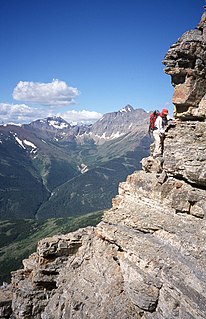
The most difficult path (difficulty EEA) starts in Toline (188m), a hamlet southwest of Pisogne, following the trail marker CAI n. 212. Steep, it becomes a via ferrata (for which adequate equipment is required) in the final stretch, preceded and followed by some delicate passages on rocks. Suitable for trained and equipped hikers, it exceeds 1060m in height and it takes about 3 hours as a whole.[2]
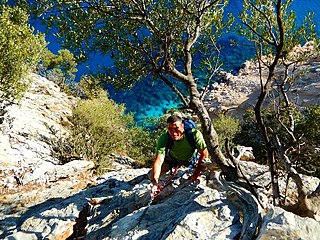
Two paths (CAI trail no. 263 and no. 265) run along the southern side of the mountain. The first (difficulty EE) has some delicate passages and takes 2 hours and 30 minutes, while the second is easier but longer (3 hours, difficulty E).[3] Since 2011, these paths have been the scene of a spectacular foot race called the Trentapassi Skyrace.[4]
In the hamlet of Cusato (689m), the shortest, and in many ways less demanding, route begins. Marked as CAI trail no. 229, it is initially a cobbledmule track at the bottom that climbs to the Coloreto hut (895m) and on to the saddle (942m) where it crosses other signposted paths and continues to the panoramic summit. Technically easy (difficulty E), it takes 1 hour and 30 minutes.[5]
Longs Peak is a high and prominent mountain in the northern Front Range of the Rocky Mountains of North America. The 14,259-foot (4346 m) fourteener is located in the Rocky Mountain National Park Wilderness, 9.6 miles (15.5 km) southwest by south of the Town of Estes Park, Colorado, United States. Longs Peak is the northernmost fourteener in the Rocky Mountains and the highest point in Boulder County and Rocky Mountain National Park. The mountain was named in honor of explorer Stephen Harriman Long and is featured on the Colorado state quarter.
Scrambling is "a walk up steep terrain involving the use of one's hands". It is an ambiguous term that lies somewhere between hiking, hillwalking, mountaineering and rock climbing. Sure-footedness and a head for heights are essential. Canyoning, Gill and stream scrambling are other types of scrambling. Gill scrambling in the UK is a type of scrambling where the base rule "is to take the hardest route and the one closest to the water, straying from the streambed only when the direct way is impassable".
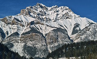
Cascade Mountain is a mountain located in the Bow River Valley of Banff National Park, adjacent to the town of Banff. The mountain was named in 1858 by James Hector after the waterfall or cascade on the southern flanks of the peak. The mountain has also been called Stoney Chief, which is related to the name of the smaller neighbouring mountain Stoney Squaw, which is still in use. Cascade is the highest mountain adjacent to the townsite.
Toubkal or Tubkal is a mountain peak in southwestern Morocco, located in the Toubkal National Park. At 4,167 metres (13,671 ft), it is the highest peak in the Atlas Mountains, Morocco, and North Africa. Located 63 km (39 mi) south of the city of Marrakesh, and visible from it, Toubkal is an ultra prominent peak, the highest for over 2,000 km (1,200 mi). For climbers it is "the most popular mountain objective in the Atlas mountains".
Hunter Mountain is in the towns of Hunter and Lexington, just south of the village of Hunter, in Greene County, New York, United States. At approximately 4,040 feet (1,231 m) in elevation, it is the highest peak in the county and the second-highest peak in the Catskill Mountains.
Huayna Potosí is a mountain in Bolivia, located near El Alto and about 25 km north of La Paz in the Cordillera Real.
Blue Knob State Park is a 6,128-acre (2,480 ha) Pennsylvania state park in Kimmel, Lincoln, and Pavia townships in Bedford County, Pennsylvania, in the United States. The average annual snowfall at the park is about 12 feet (370 cm). The park is named for Blue Knob, the second highest mountain in Pennsylvania at 3,146 feet (959 m). It is the location of Blue Knob All Seasons Resort, the ski slope in Pennsylvania with the highest elevation. Blue Knob State Park is just off Interstate 99 on Pennsylvania Route 869 west of Pavia.
Huayna Picchu, Quechua: Wayna Pikchu, is a mountain in Peru around which the Urubamba River bends. It is located in the Cusco Region, Urubamba Province, Machupicchu District. It rises over Machu Picchu, the so-called lost city of the Incas. The Incas built a trail up the side of the Huayna Picchu and built temples and terraces on its top. The peak of Huayna Picchu is 2,693 metres (8,835 ft) above sea level, or about 260 metres (850 ft) higher than Machu Picchu.
Kaaterskill High Peak is one of the Catskill Mountains, located in the Town of Hunter in Greene County, New York, United States. It was once believed to be the highest peak in the entire range, but its summit, at 3,655 feet in elevation, places it only 23rd among the Catskill High Peaks. It is, however, the fourth most prominent peak in the range. Due to its situation as the easternmost High Peak, its summit is just outside the watersheds of New York City's reservoirs in the region.
The Devil's Path is a hiking trail in the Greene County section of the Catskill Mountains of New York, sometimes described as one of the more challenging trails in the New York Tri-state area. It goes across the eponymous mountain range and then three other peaks to the west, offering hikers and peakbaggers a chance to reach the summits of five of the 35 Catskill High Peaks. It draws hikers from not just the region but far outside, due to the challenging climbs straight up and down the steep gaps between the four peaks of the range, which often require hikers to use hands as well as feet to pull themselves almost straight up cliffs and through rocky chutes. These climbs, however, lead to views across the Catskill range.
Piz Kesch (German) or Piz d'Es-cha (Rumantsch) is a peak in the Albula Alps of the Rhaetian Alps in Switzerland. At 3,418 metres (11,214 ft), it is the highest peak in the Albula Alps and the municipality of Bergün, Grisons.
Rusk Mountain is a peak located in the towns of Jewett and Lexington in Greene County, New York, United States. At 3,680 feet in elevation, it is the 20th-highest peak in the Catskill Mountains and considered a member of the Catskill High Peaks. While there is no maintained trail, a bushwhack to the summit is considered relatively easy, and required for membership in the Catskill Mountain 3500 Club.
Tumbledown Mountain is a mountain in Franklin County, Maine. The mountain is a popular hiking spot in western Maine, with trailheads located on Byron Road in unincorporated Township 6, north of Weld. It is distinguished by an alpine pond just below the summit. Tumbledown Mountain is also located near Coos Canyon, a mountain stream. Tumbledown offers trails of varying difficulty for different hikers.
The Mettelhorn is a mountain of the Swiss Pennine Alps, located near Zermatt in the canton of Valais.
Mount Kilimanjaro (/ˌkɪlɪmənˈdʒɑːroʊ/) is a dormant volcano in United Republic of Tanzania.
Piz Fora is a mountain in the Bernina Range (Alps), on the border of Italy and Switzerland. The mountain has an elevation of 3,363 metres (11,033 ft) and is the tripoint between the valleys of Val Fedoz, Val Fex and Val Malenco.
Cerro Provincia is a mountain on the eastern side of Santiago, Chile. It is a popular climb due to its accessibility and low level of difficulty by mountaineering standards. The peak has an altitude of 2,750 metres (9,022 ft) and a climb requires an altitude gain of almost 2000 meters from the highest road-accessible point. There is a small dome-shaped refuge shelter at the summit. There are fairly well traveled paths that go to the summit and marker posts. The peak offers views of Santiago to the west, the Andes to the east, and Cerro El Plomo to the north.
The Grutten Hut is an Alpine club hut at a height of 1620 metres in the Kaisergebirge in Tyrol in Austria. It is owned by the Turner Alps Kränzchen Section of the German Alpine Club.
Poke-O-Moonshine Mountain, spelled Pokamoonshine on U.S. Geological Survey maps, and sometimes known as just Poke-O, is a minor peak of the Adirondack Mountains. The name is believed to be a corruption of the Algonquin words pohqui, meaning 'broken', and moosie, meaning 'smooth'. It is located in the town of Chesterfield, New York, United States, on New York state Forest Preserve land, part of the Taylor Pond Wild Forest complex within the Adirondack Park. Due to its location next to the pass through which most travelers from the north enter the range, it has been called the "gateway to the Adirondacks".
The Selvaggio Blu is a trekking route in the territory of the district of Baunei (Sardinia). It was conceived in 1987 by Mario Verin, and Peppino Cicalò (architect), President of the Nuoro section of the Italian Alpine Club. The itinerary extends for over 40 kilometers from the touristic port of Santa Maria Navarrese (Baunei) to the beach of Cala Sisine (Baunei). It takes on average 4 days to complete.
This page is based on this Wikipedia article Text is available under the CC BY-SA 4.0 license; additional terms may apply. Images, videos and audio are available under their respective licenses.