
Livermore is a city in Alameda County, California. With a 2020 population of 87,955, Livermore is the most populous city in the Tri-Valley, giving its name to the Livermore Valley. It is located on the eastern edge of California's San Francisco Bay Area, making it the easternmost city in the area. The current mayor is John Marchand.

Altamont Pass, formerly Livermore Pass, is a low mountain pass in the Diablo Range of Northern California between Livermore in the Livermore Valley and Tracy in the San Joaquin Valley. The name is actually applied to two distinct but nearby crossings of the range. The lower of the two, at an elevation of 741 ft (226 m), carries two railroad rights-of-way (ROWs) and Altamont Pass Road, part of the old Lincoln Highway and the original alignment of US 50 before it was bypassed in 1937. The bypass route travels over the higher summit, at 1,009 ft (308 m), and now carries Interstate 580, a major regional highway heavily congested by Central Valley suburbanization.

Niles Canyon is a canyon in the San Francisco Bay Area formed by Alameda Creek, known for its heritage railroad and silent movie history. The canyon is largely in an unincorporated area of Alameda County, while the western portion of the canyon lies within the city limits of Fremont and Union City. The stretch of State Route 84 known as Niles Canyon Road traverses the length of the canyon from the Niles district of Fremont to the unincorporated town of Sunol. Two railroads also follow the same route down the canyon from Sunol to Niles: the old Southern Pacific track along the north side, now the Niles Canyon Railway, and the newer Union Pacific track a little to the south. At the west end of the canyon are the ruins of the Vallejo Flour Mill, which dates to 1853.
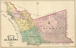
Murray Township was a township located in what is now the Livermore Valley portion of Alameda County, California, including the present day cities of Livermore, Dublin, and Pleasanton, and the census-designated place of Sunol.

The Diablo Range is a mountain range in the California Coast Ranges subdivision of the Pacific Coast Ranges in northern California, United States. It stretches from the eastern San Francisco Bay Area at its northern end to the Salinas Valley area at its southern end.
The Alameda and San Joaquin Railroad was incorporated on May 1, 1895, to serve the coal mines of the San Francisco & San Joaquin Coal Company at Corral Hollow. The 36.6-mile (58.9 km) line ran from Tesla to Carbona just south of Tracy and then up to Lathrop and Stockton. The line was constructed in 1895. On July 25, 1903, the line was sold to the Western Pacific Railway (WP).
The Tesla Fault can be found in the northeastern Diablo Range, California. This fault is only semi-active.
Arroyo Mocho is a 34.7-mile-long (55.8 km) stream which originates in the far northeastern corner of Santa Clara County and flows northwesterly into eastern Alameda County, California. After traversing the cities of Livermore and Pleasanton it joins South San Ramon Creek to become Arroyo de la Laguna, which in turn flows to Alameda Creek and thence to San Francisco Bay.
Carnegie State Vehicular Recreation Area is a state park unit of California, U.S., providing off-roading opportunities in the Diablo Range. Located in southern Alameda and San Joaquin counties, it is one of eight state vehicular recreation areas (SVRAs) administered by the California Department of Parks and Recreation. With a diversity of terrain ranging from rolling hills to steep canyons, Carnegie has become a popular destination for off-road enthusiasts of all skill levels.

The Livermore Valley, historically known as the Valle de San José, is a valley in Alameda County, California, located in the East Bay region. The city of Livermore is located in the valley.
There are 45 routes assigned to the "J" zone of the California Route Marker Program, which designates county routes in California. The "J" zone includes county highways in Alameda, Calaveras, Contra Costa, Fresno, Kern, Inyo, Mariposa, Merced, Sacramento, San Benito, San Joaquin, Stanislaus, and Tulare counties.
Vasco Road is a roadway over the Diablo Range that connects Livermore and Brentwood, California. Although it is not part of the California State Highway system, it is the principal north–south commuter route serving eastern Alameda and Contra Costa counties. The two counties are each responsible for maintaining the portion of the road within their boundaries.
El Camino Viejo a Los Ángeles, also known as El Camino Viejo and the Old Los Angeles Trail, was the oldest north-south trail in the interior of Spanish colonial Las Californias (1769–1822) and Mexican Alta California (1822–1848), present day California. It became a well established inland route, and an alternative to the coastal El Camino Real trail used since the 1770s in the period.
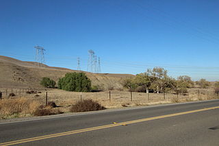
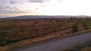
Corral Hollow, formed by Corral Hollow Creek, is a canyon partially located in Alameda County, with parts in San Joaquin County, 6.5 miles (10.5 km) southwest of Tracy, California. Corral Hollow Creek, formerly El Arroyo de los Buenos Ayres, from its source 1.9 miles (3.1 km) north of Mount Boardman, flows north 1.89 miles where it turns to flow west-northwest 8.5 miles (13.7 km) then turns abruptly east in the vicinity of Tesla to flow 5 miles (8.0 km) east where it turns again in a northeasterly direction for 6 miles (9.7 km) to the Delta-Mendota Canal in the San Joaquin Valley.
Carbona is an unincorporated community in San Joaquin County, California, United States. Carbona is located on West Linne Road, 3.1 miles (5.0 km) south southeast of Tracy. Carbona's post office is Tracy but has its own ZIP code 95304.
Carnegie was a town in Corral Hollow, in San Joaquin County, California from 1902 to about 1915.
Corral Hollow Creek, originally El Arroyo de los Buenos Ayres, later Buenos Ayres Creek, is a stream and tributary of the San Joaquin River, flowing through Alameda County and San Joaquin County, Central California.
Earle E. Williams (1898–1983) was a California historian who wrote articles, pamphlets, essays and biographies focused on the region around southwest San Joaquin County and Tracy, California, where he grew up in and lived nearly all his life.
La Vereda del Monte was a backcountry route through remote regions of the Diablo Range, one of the California Coast Ranges. La Vereda del Monte was the upper part of La Vereda Caballo,, used by mesteñeros from the early 1840s to drive Alta California horses to Sonora for sale.
Castle Rock, originally known as La Centinela, is a pillar in Corral Hollow, in San Joaquin County, California. It rises to an elevation of 653 feet (199 m).
