
The stone spheres of Costa Rica are an assortment of over 300 petrospheres in Costa Rica, on the Diquís Delta and on Isla del Caño. Locally, they are also known as bolas de piedra. The spheres are commonly attributed to the extinct Diquís culture, and they are sometimes referred to as the Diquís Spheres. They are the best-known stone sculptures of the Isthmo-Colombian area.
Tempisque Conservation Area is an administrative area which is managed by SINAC for the purposes of conservation in the western part of Costa Rica, including the Tempisque River valley and the Nicoya Peninsula. It contains a number of National Parks, Wildlife refuges and Forest Reserves.

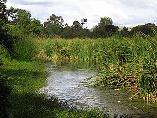
Zapandí Riverine Wetlands, is a nature reserve in Guanacaste Province, northwestern Costa Rica, created by decree 22732-MIRENEM in 1993.
Alerce Costero National Park is a protected wild area in the Cordillera Pelada about 137 km from Valdivia and 49 km from La Unión. Fitzroya trees grow inside the protected area and give the area its name, with Alerce Costero translating as Coastal Fitzroya. The Natural Monument has a total area of 137 hectares.

The Bogotá savanna is a montane savanna, located in the southwestern part of the Altiplano Cundiboyacense in the center of Colombia. The Bogotá savanna has an extent of 4,251.6 square kilometres (1,641.6 sq mi) and an average altitude of 2,550 metres (8,370 ft). The savanna is situated in the Eastern Ranges of the Colombian Andes.

Tlatlaya is a small town and municipality located in the southeast of the State of Mexico in Mexico. The word “Tlatlaya” means when the hearth is black and red.
Luvianos is a small town and municipality located in the southwest of the State of Mexico. It gained municipal status in 2000. People can access Luvianos by driving Federal Road 134 south from Toluca, and then take a detour about 25 minutes north of Tejupilco. The name is derived from a hacienda what was established during colonial times.

The Gulf of Chiriquí National Marine Park is located in the Gulf of Chiriquí, on the Pacific coast of Panama. It was established in 1994 to protect 150 square kilometres (58 sq mi) of marine ecosystems, including coral reef, mangrove swamp and marine meadow, and around two dozen islands of the archipelago of Isla Parida. In total, the park has 25 islands and 19 coral reefs.
Wetlands of Bogotá, Colombia are important areas of the capital city, and their development has become increasingly important for the area north of the Andes. A reserve for fauna and flora, the wetlands provide for the preservation and reproduction of a wide variety of mammals, reptiles and birds. These include more than 95 species of migratory birds, as well as many endemic plant species. The wetlands are part of the Bogotá River basin. The wetland complex has been designated as a protected Ramsar site since 2018.

Córdoba is a wetland, part of the Wetlands of Bogotá in Bogotá, Colombia. It is situated on the Bogotá savanna in the locality Suba between the Avenida Boyacá and Avenida Córdoba and the streets Calle 127 and Calle 116, close to the TransMilenio stations Av. Suba Calle 116 and namesake station Humedal Córdoba. The wetland covers about 40 hectares.

The Juan Amarillo, Arzobispo, or Salitre River is a river on the Bogotá savanna and a left tributary of the Bogotá River in Colombia. The river originates from various quebradas in the Eastern Hills and flows into the Bogotá River at the largest of the wetlands of Bogotá, Tibabuyes, also called Juan Amarillo Wetland. The total surface area of the Juan Amarillo basin, covering the localities Usaquén, Chapinero, Santa Fe, Suba, Barrios Unidos, Teusaquillo, and Engativá, is 12,892 hectares. Together with the Fucha and Tunjuelo Rivers, the Juan Amarillo River forms part of the left tributaries of the Bogotá River in the Colombian capital.
San Antonio is a district of the Nicoya canton, in the Guanacaste province of Costa Rica.

Bonilla-Bonillita Lacustrine Wetland is a protected area in Costa Rica, managed under the Caribbean La Amistad Conservation Area and created in 1994 under decree 23004-MlRENEM to protect the Lake Bonilla, Lake Bonillita on the west side of Reventazón River, and Lake Lancaster Arriba and Lake Lancaster Abajo on the east side of Reventazón River.
Cañas River Lacustrine Wetland, is a protected area in Costa Rica, managed under the Tempisque Conservation Area, it was created in 1994 by decree 23075-MIRENEM.
Madrigal Lake Wetland, is a protected area in Costa Rica, managed under the Arenal Tempisque Conservation Area, it was created in 1994 by decree 23076-MIRENEM.
Paraguas Lake Lacustrine Wetland, is a protected area in Costa Rica, managed under the Pacific La Amistad Conservation Area, it was created in 1994 by decree 22880-MIRENEM.
San Vito Wetland, is a protected area in Costa Rica, managed under the Pacific La Amistad Conservation Area, it was created in 1994 by decree 22879.
Térraba-Sierpe Wetland, is a protected area in Costa Rica, managed under the Osa Conservation Area, it was created in 1994 by decree 22993-MIRENEM. It has been designated as a protected Ramsar site since 1995.
Playa Blanca Marine Wetland, is a protected area in Costa Rica, managed under the Central Pacific Conservation Area, it was created in 1994 by decree 23127-MIRENEM.
Puntarenas Estuary and Associated Mangrove Swamps Wetland, is a protected area in Costa Rica, managed under the Central Pacific Conservation Area, it was created in 2006 by decree 33327-MINAE.
