Related Research Articles
Seven Mile Island or Seven Mile Beach is the name of a barrier island on the Jersey Shore in Cape May County, New Jersey, United States. It is divided between the boroughs of Avalon to the north, from 6th to 80th Streets, and Stone Harbor to the south, from 80th Street to Hereford Inlet.

A body of water or waterbody is any significant accumulation of water on the surface of Earth or another planet. The term most often refers to oceans, seas, and lakes, but it includes smaller pools of water such as ponds, wetlands, or more rarely, puddles. A body of water does not have to be still or contained; rivers, streams, canals, and other geographical features where water moves from one place to another are also considered bodies of water.
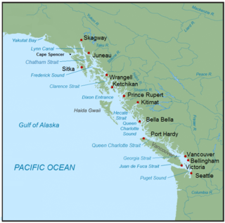
The Inside Passage is a coastal route for ships and boats along a network of passages which weave through the islands on the Pacific Northwest coast of the North American Fjordland. The route extends from southeastern Alaska in the United States, through western British Columbia in Canada, to northwestern Washington state in the United States. Ships using the route can avoid some of the bad weather in the open ocean and may visit some of the many isolated communities along the route. The Inside Passage is heavily travelled by cruise ships, freighters, tugs with tows, fishing craft, pleasure craft, and ships of the Alaska Marine Highway, BC Ferries, and Washington State Ferries systems. Coast Guard vessels of both Canada and the United States patrol and transit in the Passage.

Shelikof Strait is a strait on the southwestern coast of the U.S. state of Alaska between the Alaska mainland to the west and Kodiak and Afognak islands to the east.
Ocean Drive is a series of local roads in southern New Jersey, connecting Atlantic City to Cape May along barrier islands on the Atlantic Ocean. It consists of several roads and includes all five toll bridges owned by the Cape May County Bridge Commission.

Corson's Inlet State Park was established by the New Jersey Legislature in 1969 to protect and preserve one of the last undeveloped tracts of land along the state's oceanfront. The park borders Corson Inlet. The area's natural habitats are teeming with wildlife established in the numerous primary and secondary sand dune systems, shoreline overwash, marine estuaries, and upland areas. The park offers scenic beauty and opportunities for observing a multitude of migratory and residential wildlife species. The park itself is located in Cape May County, just south of Ocean City. The park is operated and maintained by the New Jersey Division of Parks and Forestry.
Brigantine Island is an island off the Atlantic Ocean coast of New Jersey, located northeast of Atlantic City. It is 6 miles (9.7 km) long. The resort community of Brigantine is located on the island.
Ludlam Island is a barrier island in southern New Jersey, on which Sea Isle City, and Strathmere, a part of Upper Township are located.
The New Jersey Coastal Heritage Trail Route extends along eastern and southern coast of New Jersey for nearly 300 miles. It travels along the Raritan Bay from Perth Amboy to Sandy Hook, along Jersey Shore at the Atlantic Ocean to Cape May, and along the Delaware Bay to the Delaware Memorial Bridge. The trail encompasses a variety of New Jersey state parks along with facilities under the jurisdiction of the National Park Service.
Timbalier Bay is a bay in southeastern Louisiana in the United States.

Absecon Inlet is a narrow strait on the southeastern coast of New Jersey, United States.
Oyster Bay, also known as Oyster Bay Harbor, is an inlet of Long Island Sound on the north shore of Long Island in New York in the United States.

The Southern Shore Region is located in the South Jersey region of New Jersey. It is one of six tourism regions established by the New Jersey State Department of Tourism, the others are the Gateway Region, Greater Atlantic City, the Delaware River Region, the Shore Region. and the Skylands Region. The area includes Cape May County and Cumberland County. The coast is along the Atlantic Ocean and Delaware Bay, while the inland areas are part of the New Jersey Pine Barrens.
A gut is a narrow coastal body of water, a channel or strait, usually one that is subject to strong tidal currents flowing back and forth. The term is also used in some places for a small creek.
Pecks Beach or Peck's Beach is a barrier island located on the Jersey Shore in Cape May County, New Jersey.
Brigantine Inlet is an inlet connecting Little Bay with the Atlantic Ocean in Atlantic County, New Jersey.
Townsends Inlet is an inlet connecting Townsend Sound with the Atlantic Ocean in Cape May County, New Jersey.
Hereford Inlet is an inlet in Cape May County, New Jersey.
Cape May Inlet is an inlet in southeastern Cape May County, New Jersey.

Turtle Gut Inlet was an inlet located in what is now Wildwood Crest, in Cape May County, New Jersey, United States.
References
- Merriam Webster's Geographical Dictionary, Third Edition. Springfield, Massachusetts: Merriam-Webster, Incorporated, 1997. ISBN 0-87779-546-0.
- This article incorporates text from the public domain Dictionary of American Naval Fighting Ships .The entry can be found here. (See ship namesake paragraph.)
- Lehman, D.(Ed.) (2006). A.R. Ammons: Selected Poems. American Poets Project, pp. 18–22. New York: Library of America.
39°12′20″N74°38′57″W / 39.20556°N 74.64917°W
| | This Cape May County, New Jersey state location article is a stub. You can help Wikipedia by expanding it. |