
Aracaju is the capital of the state of Sergipe, Brazil, located in the northeastern part of the country on the coast, about 350 km (217 mi) north of Salvador. According to the 2020 estimate, the city has 664,908 inhabitants, which represents approximately 33% of the state population. Adding to the populations of the municipalities forming the Metropolitan area: Barra dos Coqueiros, Nossa Senhora do Socorro and São Cristóvão. Its Metropolitan Cathedral Nossa Senhora da Conceiçao, dedicated to Our Lady of Immaculate Conception, is the archiepiscopal see of the Roman Catholic Archdiocese of Aracaju.

Santo Amaro, also known as Santo Amaro da Purificação, is a municipality in the state of Bahia in Brazil. The population is 60,131 in an area of 492.9 square kilometres (190.3 sq mi). It is located in the metropolitan area of Salvador. Santo Amaro is located approximately 73 kilometres (45 mi) from the city of Salvador. Santo Amaro was home to numerous indigenous peoples until the arrival of the Portuguese, who developed the region for sugarcane production. Santo Amaro is now noted for its numerous historic structures. The city is also a center of Candomblé, having more than 60 terreiros, or temples of the religion.
Nossa Senhora may refer to the following places:

São Cristóvão is a Brazilian municipality in the Northeastern state of Sergipe. Founded at the mouth of the Vaza-Barris River on January 1, 1590, the municipality is the fourth oldest settlement in Brazil. São Cristóvão is noted for its historic city square, São Francisco Square, and numerous early colonial-period buildings. The 3 hectares site was designated a UNESCO World Heritage Site in 2010.

Areia Branca is a municipality located in the Brazilian state of Sergipe. Its population was 18,686 (2020) and it covers 148.13 km2 (57.19 sq mi). Areia Branca has a population density of 120 inhabitants per square kilometer. It is located 36 km (22 mi) from the state capital of Sergipe, Aracaju. The municipality contains part of the Serra de Itabaiana National Park.

Laranjeiras is a municipality located in the Brazilian state of Sergipe. Its population was 30,080 (2020) and covers 162.27 km2 (62.65 sq mi). Laranjeiras has a population density of 180 inhabitants per square kilometer. Laranjeiras is located 19 km (12 mi) from the state capital of Sergipe, Aracaju. It borders the municipalities of Riachuelo, Areia Branca, Nossa Senhora do Socorro, São Cristóvão, Maruim, and Santo Amaro das Brotas, all within the state of Sergipe. The municipality contains part of the Serra de Itabaiana National Park.
Maruim is a municipality located in the Brazilian state of Sergipe. Its population was 17,271 (2020) and covers 95.55 km2 (36.89 sq mi). Maruim has a population density of 180 inhabitants per square kilometer. It is located 30 km (19 mi) from the state capital of Sergipe, Aracaju. Maruim borders the municipalities of Laranjeiras, Rosário do Catete, and Santo Amaro das Brotas, all within the state of Sergipe.

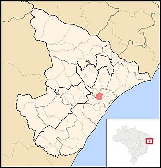
Nossa Senhora do Socorro is a municipality located in the Brazilian state of Sergipe. Its population was 185,706 (2020) and its area is 155.02 km2 (59.85 sq mi). Nossa Senhora do Socorro is located 36 km (22 mi) from the state capital of Sergipe, Aracaju.
Riachuelo is a municipality located in the Brazilian state of Sergipe. Its population was 10,284 (2020) and covers 78.31 km2 (30.24 sq mi). Riachuelo has a population density of 130 inhabitants per square kilometer. Riachuelo is located 23 km (14 mi) from the state capital of Sergipe, Aracaju. Riachuelo borders the municipalities of Laranjeiras, Divina Pastora, Santa Rosa de Lima, and Areia Branca, all within the state of Sergipe. The municipality is site of the Nossa Senhora da Penha Sugar Plantation and the Chapel of the Nossa Senhora da Penha Sugar Plantation. The chapel was listed as a historic structure by National Institute of Historic and Artistic Heritage (IPHAN) in 1943, but has fallen into an advanced state of neglect and decay and is considered abandoned.
Tomar do Geru is a municipality located in the Brazilian state of Sergipe. Its population was 13,535 (2020) and it covers 305 km2 (118 sq mi). Tomar do Geru has a population density of 43 inhabitants per square kilometer. It is located 131 km (81 mi) from the state capital of Sergipe, Aracaju. The Church of Nossa Senhora do Socorro was built by the Society of Jesus in 1688. It was listed as a historic structure by the Brazilian National Institute of Historic and Artistic Heritage (IPHAN) in 1943.

The Vaza-Barris River is a river in northeastern Brazil. The Vaza-Barris originates in northeastern Bahia state, and flows east through Bahia and Sergipe states to empty into the Atlantic Ocean near São Cristóvão.

Rosário do Sul is a Brazilian municipality in the southwestern part of the state of Rio Grande do Sul. The population is 39,314 in an area of 4,369.65 km2. Its elevation is 151 m. It is located 385 km west of the state capital of Porto Alegre. Its main industry is agriculture. Many Argentine and Uruguayan tourists visits during the spring, with a large infrastructure to accommodate the visitors.

Serra de Itabaiana National Park is a national park in the state of Sergipe, Brazil.

São Francisco do Conde is a municipality in the state of Bahia in the North-East region of Brazil. São Francisco do Conde covers 262.856 km2 (101.489 sq mi), and has a population of 40,245 with a population density of 150 inhabitants per square kilometer. It is located 67 kilometres (42 mi) from the state capital of Salvador. According to the Brazilian Institute of Geography and Statistics São Francisco do Conde has the highest concentration of Brazilians of African descent (90%) in Bahia.

Nazaré, also known as Nazaré das Farinhas, is a municipality in the state of Bahia in the North-East region of Brazil. The municipality has a population of 28,594 with a population density of 107 inhabitants per square kilometer. It is located 110 km (68 mi) from the state capital of Bahia, Salvador. Nazaré is within the Bahian Recôncavo, an interior region of the state of Bahia. It borders the municipalities of Muniz Ferreira, Aratuípe, Jaguaripe, São Felipe, and Maragogipe. The Jaguaripe River crosses through the middle of the town. It is sits on the intersection of two Bahian state highways, BA-001 and BA-046.
Sede ("Seat") is a district of the municipality of Santa Maria, in the Brazilian state of Rio Grande do Sul. It is situated in the north portion of Santa Maria. Downtown Santa Maria is one of its bairros (neighbourhoods).

The Chapel of the Nossa Senhora da Penha Sugar Plantation is an 18th-century Roman Catholic church in the city of Riachuelo, Sergipe, Brazil. It is located approximately 39 kilometres (24 mi) from the state capital of Aracaju at the border of the municipalities of Riachuelo and Malhador. It was built as part of the Nossa Senhora da Penha Sugar Plantation and was listed as a historic structure by National Institute of Historic and Artistic Heritage (IPHAN) in 1943. It has fallen into an advanced state of neglect and decay and is considered abandoned.
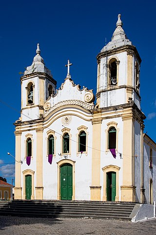
The Parish Church of the Sacred Heart of Jesus is an 18-century Roman Catholic church in Laranjeiras, Sergipe, Brazil. It was the second church built in Laranjeiras, following the Church of Our Lady of the Conception of Comandaroba, which was built by the Jesuits in the early 18th century. The church was listed as a historic structure by National Institute of Historic and Artistic Heritage (IPHAN) in 1941. The church is dedicated to the Sacred Heart of Jesus and is constructed in the Baroque style. The Parish Church belongs to the Roman Catholic Archdiocese of Aracaju.

The Church of Our Lady of the Conception of Comandaroba is an 18th-century Roman Catholic church in Laranjeiras, Sergipe, Brazil. It was established by the Jesuits and was passed to the Carmelite order after its construction. It is dedicated to is dedicated to Our Lady of the Conception and is owned by the Roman Catholic Archdiocese of Aracaju. The church was listed as a historic structure by National Institute of Historic and Artistic Heritage (IPHAN) in 1941.
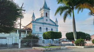
The Parish Church of Nossa Senhora do Socorro is an 18th-century Roman Catholic church in Nossa Senhora do Socorro, Sergipe, Brazil. It is dedicated to is dedicated to Our Lady of Perpetual Help and is owned by the Roman Catholic Archdiocese of Aracaju. It likely built by the Jesuits in a style typical of the Portuguese colonial period, with a Baroque-style façade with a monumental pediments and two large bell towers. The church was listed as a historic structure by National Institute of Historic and Artistic Heritage (IPHAN) in 1943. The historian José Anderson Nascimento calls it "an expressive landmark of colonial architecture in Sergipe del Rei."
