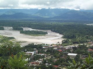
Villa Tunari or Tunari is a location in the department of Cochabamba, Bolivia. It is the seat of the Villa Tunari Municipality, the third municipal section of the Chapare Province. According to the census 2012 the population was 3,213 in the town which is an increment from 2,510 registered during the 2001 census.

Camiri is a city in Bolivia, Santa Cruz Department, Cordillera Province. It is the seat of the Camiri Municipality. The town has an estimated population of 65,897 inhabitants, also known as "Camireños." Camiri is on the banks of the Parapeti River in a small valley surrounded by rolling hills on the east, north, and south, and by the Aguarague mountain range on the west.

San Borja is a city in the Beni Department in northern Bolivia, It is the most populous city in the province of General José Ballivián.

Monteagudo is a small town in South Eastern Bolivia. Its name is dedicated to Bernardo de Monteagudo Cáceres (1789-1825) who took part in the Chuquisaca revolution of 25 May 1809.
Pocona is a location in the Cochabamba Department in central Bolivia. It is the seat of the Pocona Municipality, the third municipal section of the Carrasco Province. At the time of census 2001 it had a population of 244.

Irupana is a location in the La Paz Department in Bolivia. It is the seat of the Irupana Municipality, the second municipal section of the Sud Yungas Province.
Luribay is a location in the La Paz Department in Bolivia. It is the seat of the Luribay Municipality, the first municipal section of the José Ramón Loayza Province, and of the province.

Tiquipaya is a town in the Cochabamba Department in central Bolivia. It is the seat of the Tiquipaya Municipality, the third municipal section of the Quillacollo Province. It is known as the "city of flowers". The town hosts many dairy farmers and is known as a well visited and productive zone with surprising climatic diversity due to valleys, high plains, and sub-tropical regions. The town homes the Universidad del Valle (UNIVALLE) that helps in the economy of the region as a result of the services required. Around 2% of the population of Tiquipaya was born in a foreign country. Most of them are students from Brasil.
San Ramón is a small town in the Beni Department in Bolivia.
Don Lorenzo is a small town in the Santa Cruz Department in the South American Andean Republic of Bolivia.
Campanero is a small town in the Santa Cruz Department in the South American Andean Republic of Bolivia.
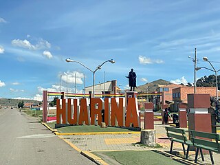
Huarina is a location in the La Paz Department in Bolivia. It is the seat of the Huarina Municipality, one of the four municipalities of the Omasuyos Province. President of Peru Andrés de Santa Cruz was born here.
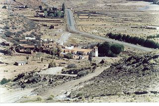
Tarapaya is one of the cantons of the Potosí Municipality, the capital municipality of the Tomás Frías Province in the Potosí Department of Bolivia. During the census of 2001 it had 1,042 inhabitants. Its seat is Tarapaya with a population of 11 in 2001. It is situated east of Tarapaya River.

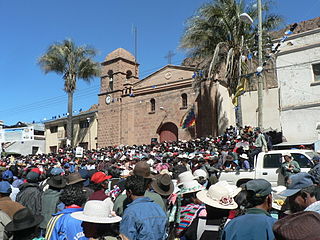
Azurduy Municipality is the first municipal section of Azurduy Province in the Chuquisaca Department of Bolivia. Its seat is Villa Azurduy. In 2012 the population was 10,594 persons. The municipality is very poor; in 2010 93% were below the poverty line, and 75% were in extreme poverty. In 2001 there were seven automobiles in the municipality.

San Agustín is a village located in the Potosí Department of Bolivia. It is the capital of the San Agustín Canton, San Agustín Municipality and Enrique Baldivieso Province.
Mineros is a city of Bolivia, capital of the Mineros Municipality of the Santa Cruz Department, 83 km north of the city of Santa Cruz de la Sierra. Due to the policy of the 1960s that forced the indigenous people of the Altiplano to immigrate, 23.3% of the population knows how to speak Quechua.
Puna is a village and the capital of the José María Linares Province in the Potosí Department of Bolivia.
Colcha K is a village serving as the capital of Nor Lípez Province, in the Potosí Department of Bolivia. It is also the capital of the Colcha "K" Canton and Colcha "K" Municipality.
Betanzos is a town located in the Potosí Department of Bolivia. It is the capital of the Betanzos Canton, Betanzos Municipality and Cornelio Saavedra Province.
San Antonio del Parapetí is a town in the Santa Cruz Department of Bolivia.


