County Buildings, Dumfries

Last updated

County Buildings, Dumfries
Dumfries & Galloway Council Headquarters (geograph 4699595).jpg
County Buildings, Dumfries
LocationEnglish Street, Dumfries
Coordinates 55°04′11″N3°36′24″W / 55.0698°N 3.6067°W / 55.0698; -3.6067
Built1914
Architect John Dick Peddie and James Forbes Smith
Architectural style(s) Renaissance Revival style
Listed Building – Category B
Official nameDumfries County Buildings, 113 English Street, Dumfries
Designated21 August 1987
Reference no.LB26174
Dumfries and Galloway UK location map.svg
Red pog.svg
Shown in Dumfries and Galloway

County Buildings is a municipal structure in English Street, Dumfries, Scotland. The structure, which is the headquarters of Dumfries and Galloway Council, is a Category B listed building. [1]

Contents

History

Following the implementation of the Local Government (Scotland) Act 1889, which established county councils in every county, the new county leaders decided to commission offices for Dumfriesshire County Council. [2] The site they selected formed the storehouse for the local militia barracks. [3] The main part of the old militia barracks, which was on an adjacent site to the southwest, was retained and incorporated into the new complex as additional office space. [4]

The foundation stone for the new building was laid in September 1912. [5] [6] It was designed by John Dick Peddie and James Forbes Smith in the Renaissance Revival style, built in red ashlar stone at a cost of £21,000 [7] and was completed in 1914. [1] The design involved a symmetrical main frontage with seven bays facing onto English Street with the end bays projected forward to form wings; the central bay, which slightly projected forward, featured a doorway flanked by brackets supporting a pediment. On the first floor there was a balustrade and a three-light window flanked by pilasters, and, at attic level, there was a gable containing a Diocletian window and a blind panel. Internally, the principal room was the council chamber at the rear of the building. [1]

Following the abolition of Dumfriesshire County Council, the complex became the headquarters of Dumfries and Galloway Regional Council in 1975, [8] [9] and then, after the introduction of unitary authorities, it became the headquarters of Dumfries and Galloway Council in 1996. [10]

The Queensberry Monument, which was designed by Robert Adam in memory of Charles Douglas, 3rd Duke of Queensberry, was originally erected in Queensberry Square in 1780. [11] It was moved to the forecourt of the County Buildings in 1934 but then returned to Queensberry Square as part of a project to pedestrianise the area in 1990. [12]

See also

Related Research Articles

<span class="mw-page-title-main">Dumfries</span> Town in Dumfries and Galloway, Scotland

Dumfries is a market town and former royal burgh in Dumfries and Galloway, Scotland, near the mouth of the River Nith on the Solway Firth, 25 miles (40 km) from the Anglo-Scottish border. Dumfries is the county town of the historic county of Dumfriesshire.

<span class="mw-page-title-main">Dumfries and Galloway</span> Council area of Scotland

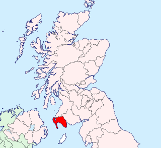
Dumfries and Galloway is one of the 32 unitary council areas of Scotland, located in the western part of the Southern Uplands. It is bordered by East Ayrshire, South Ayrshire, and South Lanarkshire to the north; Scottish Borders to the north-east; the English ceremonial county of Cumbria, the Solway Firth, and the Irish Sea to the south, and the North Channel to the west. The administrative centre and largest settlement is the town of Dumfries. The second largest town is Stranraer, located 76 miles (122 km) to the west of Dumfries on the North Channel coast.

<span class="mw-page-title-main">Kirkcudbrightshire</span> Historic county in Scotland

Kirkcudbrightshire, or the County of Kirkcudbright or the Stewartry of Kirkcudbright is one of the historic counties of Scotland, covering an area in the south-west of the country. Until 1975, Kirkcudbrightshire was an administrative county used for local government. Since 1975, the area has formed part of Dumfries and Galloway for local government purposes. Kirkcudbrightshire continues to be used as a registration county for land registration. A lower-tier district called Stewartry covered the majority of the historic county from 1975 to 1996. The area of Stewartry district is still used as a lieutenancy area. Dumfries and Galloway Council also has a Stewartry area committee.

<span class="mw-page-title-main">Wigtownshire</span> Historic county in Scotland

Wigtownshire or the County of Wigtown is one of the historic counties of Scotland, covering an area in the south-west of the country. Until 1975, Wigtownshire was an administrative county used for local government. Since 1975 the area has formed part of Dumfries and Galloway for local government purposes. Wigtownshire continues to be used as a territory for land registration, being a registration county. The historic county is all within the slightly larger Wigtown Area, which is one of the lieutenancy areas of Scotland and was used in local government as the Wigtown District from 1975 to 1996.

<span class="mw-page-title-main">Dumfriesshire</span> Historic county in Scotland

Dumfriesshire or the County of Dumfries or Shire of Dumfries is a historic county and registration county in southern Scotland. The Dumfries lieutenancy area covers a similar area to the historic county.

<span class="mw-page-title-main">Annandale and Eskdale</span> Committee area in Dumfries and Galloway, Scotland

<span class="mw-page-title-main">Nithsdale</span> Scottish local government district (1975–1996), part of Dumfries and Galloway region

<span class="mw-page-title-main">Troqueer</span> Human settlement in Scotland

Troqueer is a former village and a parish in the historic county of Kirkcudbrightshire in Dumfries and Galloway on the west side of the River Nith. The eastern-side was merged with Dumfries to the east in 1929, and today eastern Troqueer is a suburb of Dumfries.

<span class="mw-page-title-main">Kirkpatrick-Juxta</span>

<span class="mw-page-title-main">Municipal Buildings, Dumfries</span> Municipal Building in Dumfries, Scotland

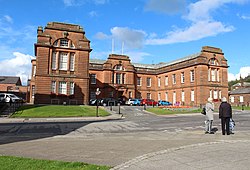
The Municipal Buildings are based on the north side of Buccleuch Street, Dumfries, Dumfries and Galloway, Scotland. The structure, which was the headquarters of Dumfries Burgh Council, is a Category C listed building.

<span class="mw-page-title-main">Wigtown County Buildings</span> Municipal building in Wigtown, Scotland

Wigtown County Buildings, also known as Wigtown County Buildings and Town Hall, is a municipal building in The Square, Wigtown, Scotland. The structure primarily served as the meeting place and town hall for Wigtown Burgh Council, but was also used for some meetings of Wigtownshire County Council. It is a Category B listed building.

<span class="mw-page-title-main">Kirkcudbright Town Hall</span> Municipal building in Kirkcudbright, Scotland

Kirkcudbright Town Hall is a municipal building in St Mary's Street, Kirkcudbright, Scotland. The building, which was the headquarters of Kirkcudbright Burgh Council, is a Category B listed building.

<span class="mw-page-title-main">Annan Town Hall</span> Municipal building in Annan, Scotland

Annan Town Hall is a municipal building in the High Street in Annan, Dumfries and Galloway, Scotland. The structure, which accommodates the local library and is also used as a venue for the provision of local services, is a Category B listed building.

<span class="mw-page-title-main">Lochmaben Town Hall</span> Municipal building in Lochmaben, Scotland

Lochmaben Town Hall is a municipal building in the High Street in Lochmaben, Dumfries and Galloway, Scotland. The structure, which accommodates a library and a local customer services point, is a Category A listed building.

<span class="mw-page-title-main">Lockerbie Town Hall</span> Municipal building in Lockerbie, Scotland

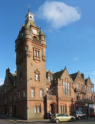
Lockerbie Town Hall is a municipal building in the High Street in Lockerbie, Dumfries and Galloway, Scotland. The structure, which is used as a venue for the provision of local services, is a Category A listed building.

<span class="mw-page-title-main">Sanquhar Tolbooth</span> Municipal building in Sanquhar, Scotland

Sanquhar Tolbooth is a municipal building in the High Street in Sanquhar, Dumfries and Galloway, Scotland. The structure, which accommodates a local history museum, is a Category A listed building.

<span class="mw-page-title-main">McMillan Hall, Newton Stewart</span> Municipal building in Newton Stewart, Scotland

The McMillan Hall is a municipal building in Dashwood Square in Newton Stewart, Dumfries and Galloway, Scotland. The structure, which is used as a community events venue, is a Category B listed building.

<span class="mw-page-title-main">County Buildings, Kirkcudbright</span> County building in Kirkcudbright, Scotland

County Buildings is a municipal building in Kirkcudbright, in the Dumfries and Galloway council area in Scotland. It was originally two houses on High Street, which then served as the main offices of Kirkcudbrightshire County Council from 1925 to 1975. A large extension to the rear was added in 1952, accessed from Daar Road. From 1975 until 1996 the building served as the offices of Stewartry District Council. Since 1996, it has been an area office of Dumfries and Galloway Council. It is a Category B listed building. Prior to the 1952 extension the name "County Buildings" was used for a different building, at 85 High Street, which was also the town's sheriff court.

<span class="mw-page-title-main">Stranraer Sheriff Court</span> Judicial building in Stranraer, Scotland

Stranraer Sheriff Court is a judicial building in Lewis Street, Stranraer, Dumfries and Galloway, Scotland. The building, which continues to be used as a courthouse, is a Category B listed building.

References

  1. 1 2 3 Historic Environment Scotland. "Dumfries County Buildings, 113 English Street, Dumfries (LB26174)" . Retrieved 16 August 2021.
  2. Shennan, Hay (1892). Boundaries of Counties and Parishes in Scotland: as settled by the Boundary Commissioners under the Local Government (Scotland) Act, 1889. Edinburgh: William Green & Sons via Internet Archive.
  3. "Ordnance Survey Map". 1894. Retrieved 16 August 2021.
  4. Smith, Mary; Kirk, Keith (2019). A-Z of Dumfries: Places-People-History. Amberley Publishing. ISBN   978-1445664729.
  5. "Dumfries County Buildings". Dictionary of Scottish Architects. Retrieved 16 August 2021.
  6. "Dumfries Conservation Area Character Appraisal and Management Plan" (PDF). Dumfries and Galloway Council. 1 May 2020. p. 10. Retrieved 16 August 2021.
  7. "County Buildings". The Buildings News and Engineering Journal. 1911. p. 635.
  8. "Local Government (Scotland) Act 1973". Legislation.gov.uk. Retrieved 16 April 2020.
  9. "Leslie Carnegie". The Herald. 11 July 1998. Retrieved 16 August 2021.
  10. "Local government facts and figures: Scotland". Local Government Information Unit. Retrieved 16 August 2021.
  11. Historic Environment Scotland. "Queensberry Monument (LB26173)" . Retrieved 16 August 2021.
  12. "Queensberry Monument". Scotland Starts Here. Retrieved 16 August 2021.