Court House Square (Charleston)

Last updated
Charleston County Courthouse (1790-92), James Hoban, architect. A likely model for The White House. CharlestonCountyCourthouse(cropped) HABS361451pv.jpg
Charleston County Courthouse (1790-92), James Hoban, architect. A likely model for The White House.

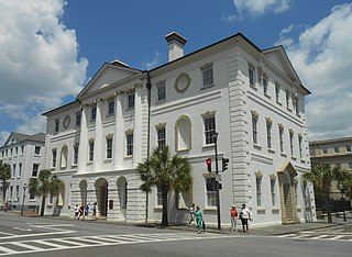
Court House Square is the location of Charleston County Courthouse in downtown Charleston, South Carolina, at the intersection of Meeting and Broad Streets. It is historically known as "the Four Corners of Law" because the intersection hosted buildings from each level of government: the Courthouse (state law), City Hall (municipal law), the Federal Building and U.S. Post Office (federal law), and Saint Michael's Episcopal Church (canon law).

Charleston County Courthouse

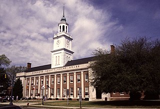
Charleston County Courthouse (1790–92) is a Neoclassical building in Charleston, South Carolina, designed by Irish architect James Hoban. It was a likely model for Hoban's most famous building, the U.S. White House, and both buildings are modeled after Leinster House, the current seat of the Irish Parliament in Dublin.

Charleston, South Carolina City in the United States

Charleston is the oldest and largest city in the U.S. state of South Carolina, the county seat of Charleston County, and the principal city in the Charleston–North Charleston–Summerville Metropolitan Statistical Area. The city lies just south of the geographical midpoint of South Carolina's coastline and is located on Charleston Harbor, an inlet of the Atlantic Ocean formed by the confluence of the Ashley, Cooper, and Wando rivers. Charleston had an estimated population of 134,875 in 2017. The estimated population of the Charleston metropolitan area, comprising Berkeley, Charleston, and Dorchester counties, was 761,155 residents in 2016, the third-largest in the state and the 78th-largest metropolitan statistical area in the United States.

The Four Corners of Law is a term commonly used to refer to the intersection of Meeting and Broad Streets in Charleston, South Carolina. It was coined in the 1930s by Robert Ripley, creator of Ripley's Believe it or Not! and refers to the buildings occupying the four corners of the intersection:

  1. St. Michael's Episcopal Church, constructed between 1752 and 1761, stands on the southeast corner of the intersection.
  2. On the northeast corner of the Four Corners is Charleston City Hall, constructed in the Adamesque style between 1800 and 1804.
  3. Across the street, on the northwest corner, stands the Charleston County Courthouse. Originally constructed in 1753 as South Carolina's provincial capital, the building was rebuilt in 1792 for use as a courthouse.
  4. On the southwest corner is the United States Post Office and Federal Courthouse, built in 1896.

Charleston County Courthouse (1790–92) was designed by the Irish-born American architect James Hoban. President George Washington visited Charleston in May 1791, may have met with Hoban, and summoned the architect to Philadelphia, Pennsylvania (the temporary national capital) in June 1792. The following month, Hoban was named winner of the design competition for The White House in Washington, DC. [1]

James Hoban architect

James Hoban was an Irish architect, best known for designing the White House in Washington, D.C.

George Washington 1st president of the United States

George Washington was an American political leader, military general, statesman, and Founding Father who also served as the first president of the United States from 1789 to 1797. He led Patriot forces to victory in the nation's War of Independence, and he presided at the Constitutional Convention of 1787 which established the new federal government. He has been called the "Father of His Country" for his manifold leadership in the formative days of the new nation.

The Courthouse itself is still in use, located in the historic district near the park at Washington Square. It was built on the site of and incorporated the ruins of the South Carolina Statehouse (1753, burned 1788), the capitol building for the Colony of South Carolina under British Rule. [2]

Charleston Historic District historic district in Charleston, South Carolina

The Charleston Historic District, alternatively known as Charleston Old and Historic District, is a National Historic Landmark District in Charleston, South Carolina. The district, which covers most of the historic peninsular heart of the city, contains an unparalleled collection of 18th and 19th-century architecture, including a large number of distinctive Charleston "single houses". It was declared a National Historic Landmark in 1960.

Washington Square (Charleston) greenspace in downtown Charleston, South Carolina

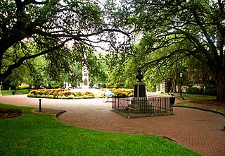
Washington Square is a park in downtown Charleston, South Carolina. It is located behind City Hall at the corner of Meeting Street and Broad Street in the Charleston Historic District. It was known as City Hall Park until October 10, 1881, when it was renamed in honor of George Washington. The new name was painted over the gates in December 1881.

Province of South Carolina UK possession in North America

The Province of South Carolina was originally part of the Province of Carolina in British America, which was chartered by eight Lords Proprietor in 1663. The province later became the U.S. state of South Carolina.

Related Research Articles

Darlington, South Carolina City in South Carolina, United States

Darlington is a city located in Darlington County, South Carolina, United States. In 2016, its population was 6,117. It is the county seat of Darlington County. It is part of the Florence, South Carolina Metropolitan Statistical Area.

Bennettsville, South Carolina City in South Carolina, United States

Bennettsville is a city located in the U.S. state of South Carolina on the Great Pee Dee River. As the county seat of Marlboro County, Bennettsville is noted for its historic homes and buildings from the 19th and early 20th centuries — including the Bennettsville Historic District which is listed on the National Register of Historic Places.

York, South Carolina City in South Carolina, United States

York is a city in and county seat of York County, South Carolina, United States. The population was approximately 6,985 at the 2000 census and up to 7,736 at the 2010 census. York is located approximately 27 miles (43 km) southwest of Charlotte, North Carolina and 13 miles (21 km) west of Rock Hill, South Carolina.

Richardsonian Romanesque Romanesque Revival architectural style, named for Henry Hobson Richardson

Richardsonian Romanesque is a style of Romanesque Revival architecture named after architect Henry Hobson Richardson (1838–1886), whose masterpiece is Trinity Church, Boston (1872–1877), designated a National Historic Landmark. Richardson first used elements of the style in his Buffalo State Asylum for the Insane in Buffalo, New York, designed in 1870.

Robert Mills, a South Carolina architect known for designing both the first Washington Monument, located in Baltimore, Maryland, as well as the better known monument to the first president in the nation's capital, Washington, DC. He is sometimes said to be the first native-born American to be professionally trained as an architect.{by whom|date=August 2013}} Charles Bulfinch of Boston perhaps has a clearer claim to this honor.

The Battery (Charleston)

The Battery is a landmark defensive seawall and promenade in Charleston, South Carolina. Named for a civil-war coastal defense artillery battery at the site, it stretches along the lower shores of the Charleston peninsula, bordered by the Ashley and Cooper Rivers, which meet here to form Charleston harbor. Historically, it has been understood to extend from the beginning of the seawall at the site of the former Omar Shrine Temple to the intersection of what is now Murray Boulevard and King Street. The higher part of the promenade, paralleling East Battery, as the street is known south of Water Street, to the intersection of Murray Boulevard, is known as High Battery. Fort Sumter is visible from the Cooper River side and from the point, as are Castle Pinckney, the World War II aircraft carrier USS Yorktown (CV-10), Fort Moultrie, and Sullivan's Island.

South Carolina State House

The South Carolina State House is the building housing the government of the U.S. state of South Carolina, which includes the South Carolina General Assembly and the offices of the Governor and Lieutenant Governor of South Carolina. Located in the capital city of Columbia near the corner of Gervais and Assembly Streets, the building also housed the Supreme Court until 1971.

Federal building building housing local offices of various government departments and agencies in countries with a federal system

A federal building is a building housing local offices of various government departments and agencies in countries with a federal system, especially when the central government is referred to as the "federal government".

William Martin Aiken was an American architect who served as Supervising Architect of the United States Treasury and oversaw and participated in the design and construction of numerous federal buildings during his appointment that now reside on the National Register of Historic Places.

Charleston Library Society

Charleston Library Society, founded in 1748, is a subscription library in Charleston, South Carolina.

United States Custom House (Charleston, South Carolina)

The U.S. Custom House or U.S. Customhouse is the custom house in Charleston, South Carolina. Construction began in 1852, but was interrupted in 1859 due to costs and the possibility of South Carolina's secession from the Union. After the Civil War, construction was restarted in 1870 and completed in 1879. The building was placed on the National Register of Historical Places on October 9, 1974. It is also a contributing property of the Charleston Historic District.

William Seabrook House plantation

The William Seabrook House, also known as the Seabrook is a plantation house built about 1810 on Edisto Island, South Carolina, United States, southwest of Charleston. It is located off Steamboat Landing Road Extension close to Steamboat Creek about 0.7 mi (1.1 km) from Steam Boat Landing. It was named to the National Register of Historic Places on May 6, 1971.

United States Post Office and Courthouse (Charleston, South Carolina) historic building in Charleston, South Carolina, United States

The U.S. Post Office and Courthouse is a historic post office and courthouse located at Charleston in Charleston County, South Carolina. The building and its annexes serve the federal court for the Charleston Division of the United States District Court for the District of South Carolina. The building was listed on the National Register of Historic Places in 1974.

Old Greenville City Hall

The Old Greenville City Hall, is a former building in Greenville, South Carolina. It was originally built as the U.S. Courthouse and Post Office in 1889 on the corner of Main and Broad Streets. After 1938, it was transferred to the City of Greenville and used as its city hall. It was named to the National Register of Historic Places on August 19, 1971. After its demolition in 1972 or 1973, it was removed from the National Register in 1973.

Tristram Hyde House

Tristram Hyde House is a historic two-story home in Charleston, South Carolina constructed in 1914 for Tristram Hyde, who soon after became mayor of Charleston in 1915. It was designed by local architect Albert Wheeler Todd.

References

  1. William Seale, "James Hoban: Builder of the White House" in White House History, no. 22 (Spring 2008), pp. 8-12.
  2. Charleston County Courthouse from National Park Service.

Coordinates: 32°46′35.814″N79°55′52.75″W / 32.77661500°N 79.9313194°W / 32.77661500; -79.9313194

Geographic coordinate system Coordinate system

A geographic coordinate system is a coordinate system that enables every location on Earth to be specified by a set of numbers, letters or symbols. The coordinates are often chosen such that one of the numbers represents a vertical position and two or three of the numbers represent a horizontal position; alternatively, a geographic position may be expressed in a combined three-dimensional Cartesian vector. A common choice of coordinates is latitude, longitude and elevation. To specify a location on a plane requires a map projection.