
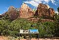
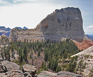
The Court of the Patriarchs is a sandstone cliff on the south face of the Three Patriarchs in Zion Canyon in Zion National Park in Washington County, Utah, United States. [1] [2]
The Court of the Patriarchs is a sandstone cliff on the south face of the Three Patriarchs in Zion Canyon in Zion National Park in Washington County, Utah, United States. [1] [2]
Spring and fall are the most favorable seasons to visit the Court of the Patriarchs. According to the Köppen climate classification system, it is located in a cold semi-arid climate zone, which is defined by the coldest month having an average mean temperature below 32 °F (0 °C), and at least 50% of the total annual precipitation being received during the spring and summer. This desert climate receives less than 10 inches (250 millimeters) of annual rainfall, and snowfall is generally light during the winter. [3]

Bee Hive is a 6,904 feet (2,104 m) Navajo Sandstone mountain in Zion National Park in Washington County, Utah, United States, that is part of the Towers of the Virgin.

Mount Spry is a small 5,720-ft elevation mountain summit made of Navajo Sandstone located in Zion National Park, in Washington County of southwest Utah, United States. Officially named in 1934, it honors William Spry (1864–1929), the third governor of Utah. The nearest higher peak is The East Temple, 0.34 miles (0.55 km) to the east. Precipitation runoff from the mountain drains into tributaries of the North Fork Virgin River.

The West Temple is a prominent 7,810-foot mountain summit composed of Navajo Sandstone in Zion National Park in Washington County of Utah, United States. The West Temple, the highest feature in Zion Canyon, was originally called "Temp-o-i-tin-car-ur" meaning "Mountain without a trail" by the Paiute people. It was called Steamboat Mountain by local Mormon settlers before 1934, when the USGS officially changed it to its present name, which was applied by John Wesley Powell during his explorations in 1872. West Temple is situated two miles northwest of Springdale, Utah, one mile northeast of Mount Kinesava, and two miles west of the park headquarters. It is one of the notable landmarks in the park. The nearest higher peak is Windy Peak, 10.46 miles (16.83 km) to the north. Precipitation runoff from the mountain drains into tributaries of the Virgin River.

The Watchman is a 6,545-foot (1,995 m) sandstone mountain summit located in Zion National Park, in Washington County of southwest Utah, United States.

Mount Moroni is a 5,690-foot (1,730 m) elevation Navajo Sandstone summit located at the Court of the Patriarchs in Zion National Park, in Washington County of southwest Utah, United States.

The Sentinel is a 7,120+ ft elevation Navajo Sandstone summit located near the Court of the Patriarchs in Zion National Park, in Washington County of southwest Utah, United States, that is part of the Towers of the Virgin. The national park map lists the elevation as 7,157-feet.

Mountain of the Sun is a 6,722-foot (2,049 m) elevation Navajo Sandstone summit located in Zion National Park, in Washington County of southwest Utah, United States. Mountain of the Sun is situated immediately east of Court of the Patriarchs, and south of Zion Lodge, towering 2,500 feet above the lodge and the floor of Zion Canyon. It is set on the east side of the North Fork of the Virgin River which drains precipitation runoff from this mountain. Its neighbors include The Sentinel, Mount Spry, The East Temple, and Mount Moroni. This feature's name was officially adopted in 1934 by the U.S. Board on Geographic Names.
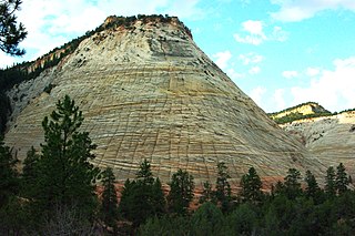
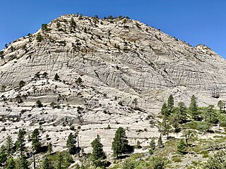
Checkerboard Mesa is an iconic 6,520+ ft elevation Navajo Sandstone summit located in Zion National Park, in Kane County of southwest Utah, United States. Checkerboard Mesa is situated immediately southwest of the park's east entrance, towering 900 feet above the Zion – Mount Carmel Highway. Its nearest neighbor is Crazy Quilt Mesa, one-half mile immediately west, and separated by Checkerboard Mesa Canyon. This canyon holds pools of rainwater which provide a vital source of water for resident bighorn sheep. This peak was originally named Checkerboard Mountain by the park's third superintendent, Preston P. Patraw. The landform's toponym was officially adopted in 1935 by the U.S. Board on Geographic Names. The descriptive name stems from the cliff's distinctive multitudinous check lines in cross-bedded white sandstone which give the impression of a checkerboard. The horizontal lines are caused by cross-bedding, a remnant of ancient sand dunes. The vertical and sub-vertical lines formed by the contraction and expansion of the sandstone caused by temperature changes, freezing and thawing cycles, in combination with wetting and drying. Precipitation runoff from this mountain drains into tributaries of the Virgin River.

Inclined Temple is a remote 7,150-foot elevation summit located in Zion National Park, in Washington County of southwest Utah, United States.
South Guardian Angel is a 7,140-foot (2,180 m) summit located in Zion National Park, in Washington County of southwest Utah, United States.
North Guardian Angel is a 7,395-foot elevation summit located in Zion National Park, in Washington County of southwest Utah, United States.

Three Marys are three sandstone pillars in Zion National Park in Washington County, Utah, United States.

Mountain of Mystery is a 6,565-foot (2,001 m) Navajo Sandstone summit located in Zion National Park, in Washington County of southwest Utah, United States. Mountain of Mystery is situated above The Narrows, towering over 2,100 feet above the floor of Zion Canyon and the North Fork Virgin River which drains precipitation runoff from this mountain. This peak rises above Orderville Canyon on its north side, and Mystery Canyon on the south. Its neighbors include Mount Majestic, Cathedral Mountain, Observation Point, Cable Mountain, Angels Landing, and The Organ. This feature's name was officially adopted in 1934 by the U.S. Board on Geographic Names. The first ascent via the Northeast Buttress was made 15 September 2001, by Brian Cabe and Tom Jones.

Pine Valley Peak is a 7,415-foot (2,260 m) mountain located in Zion National Park in Washington County, Utah, United States.

Deertrap Mountain is a 6,837-foot (2,084 m) mountain in Zion National Park in Washington County, Utah, United States.

Crazy Quilt Mesa is a 6,760 ft (2,060 m) elevation white Navajo Sandstone summit located in Zion National Park, in Kane County of southwest Utah, United States.

Cave Knoll is a 6,486-foot (1,977 m) summit located in Zion National Park, in Washington County of southwest Utah, United States. Cave Knoll, a formation composed of Navajo Sandstone, is situated in Cave Valley, 11.5 mi (18.5 km) northwest of Springdale, Utah. Its neighbors include Pine Valley Peak, 1.7 mi (3 km) to the northeast, Tabernacle Dome, 1.6 mi (3 km) to the south-southeast, and North Guardian Angel, 2.5 mi (4 km) to the east. Precipitation runoff from this mountain drains into tributaries of the Virgin River. Access to this peak is via the Kolob Terrace Road. This peak's name was officially adopted in 1934 by the U.S. Board on Geographic Names.

The Three Patriarchs is a set of three sandstone monoliths on the west side of Zion Canyon in Zion National Park in Washington County, Utah, United States. The three main peaks were named by Frederick Fisher in 1916 for the biblical figures Abraham, Isaac and Jacob. The Court of the Patriarchs is the cliff that runs along the south face of the Three Partiarchs.

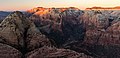
The Towers of the Virgin is a series of several lofty sandstone monoliths on the west side of Zion Canyon in Zion National Park in Washington County, Utah, United States.
Northgate Peaks are two summits in Washington County, Utah, United States.
![]() Media related to Court of the Patriarchs at Wikimedia Commons
Media related to Court of the Patriarchs at Wikimedia Commons
37°14′14″N112°57′54″W / 37.2372044°N 112.9649401°W
| | This article about a location in Utah is a stub. You can help Wikipedia by expanding it. |