Covello, Washington | |
|---|---|
 Covello  Covello | |
| Coordinates: 46°23′00″N117°49′59″W / 46.38333°N 117.83306°W | |
| Country | United States |
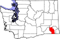
| State | Washington |
| County | Columbia |
| Elevation | 2,435 ft (742 m) |
| Time zone | UTC-8 (Pacific (PST)) |
| • Summer (DST) | UTC-7 (PDT) |
| GNIS feature ID | 1510894 [1] |
Covello is an unincorporated community in Columbia County, in the U.S. state of Washington.