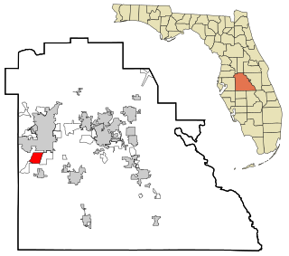
Medulla is an unincorporated community and census-designated place (CDP) in Polk County, Florida, United States. It is part of the Lakeland–Winter Haven Metropolitan Statistical Area. Medulla is an affluent residential community located south of the Lakeland city limits, and north of the Mulberry city limits. Medulla neighbors Lakeland Highlands, and together the two communities make up much of what is known as south (unincorporated) Lakeland. The population was 8,892 at the 2010 census. The area is addressed to Lakeland, with zip codes 33811 and 33813.

Fort Washington is an unincorporated area and census-designated place in Prince George's County, Maryland. It borders the capital of the United States of America, Washington, D.C., situated just south of the downtown district. As of the 2010 census it had a population of 23,717. It is a prosperous community with an African American majority population. The Fort Washington community is located west of Maryland Route 210, with some additional area to the east of the highway.

Friendly is an unincorporated area and census-designated place (CDP) in Prince George's County, Maryland, United States, with an African-American majority population, located a few miles south of Washington, D.C. The population was 9,250 at the 2010 census.
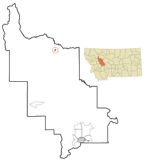
Augusta is a census-designated place (CDP) as well as a town in Lewis and Clark County, Montana, United States. The population was 364 at the 2018 census. The most accepted version in the naming of this town is after Augusta Hogan, thought to be the first child born in this town, the daughter of J. D. Hogan, an early rancher.

Port Ludlow is an unincorporated community and census-designated place (CDP) in Jefferson County, Washington, United States. It is also the name of the marine inlet on which the community is located. The CDP's population was 2,603 at the 2010 census, up from 1,968 at the 2000 census.
Silver Firs is a census-designated place (CDP) in Snohomish County, Washington, United States. The population was 20,891 at the 2010 census. It lies northeast of the city of Mill Creek. Silver Firs is one of two CDPs that were created out of the former Seattle Hill-Silver Firs CDP in 2010, the other being Eastmont.

Little Round Lake is a census-designated place (CDP) in the town of Bass Lake, Sawyer County, Wisconsin, United States. The population was 1,081 at the 2010 census. It is the largest community on the reservation of the federally recognized tribe of the Lac Courte Oreilles Band of Lake Superior Chippewa Indians.

Fobes Hill is an unincorporated community and a census-designated place (CDP) in Snohomish County, Washington, United States. The population was 2,418 at the 2010 census. Fobes Hill is a middle class residential community located along Fobes Road, northwest of the city of Snohomish.

Fredericktown is a census-designated place located in East Bethlehem Township, Washington County in the state of Pennsylvania. The community was part of the Fredericktown-Millsboro CDP for the 2000 census, but was split into two separate CDPs for the 2010 census, the other community being Millsboro. Fredericktown is located in far southern Washington County, along Pennsylvania Route 88, which travels along the Monongahela River. As of the 2010 census the population was 403 residents.

Stone Lake is an unincorporated census-designated place in Sawyer and Washburn counties, Wisconsin, United States. Stone Lake is located on the eastern shore of Stone Lake and along Wisconsin Highway 70, 12 miles (19 km) west-northwest of Couderay. The Sawyer County portion of the community is located in the town of Sand Lake, while the Washburn County portion is located in the town of Stone Lake. As of the 2010 census, its population is 178.
Big Bass Lake is a private community and census-designated place (CDP) in Clifton and Covington Townships in Lackawanna County and Lehigh Township, Wayne County, in Pennsylvania. The community's population was 1,270 at time of the 2010 United States Census.

Big Lake is an unincorporated community and census-designated place (CDP) in Perch Lake Township, Carlton County, Minnesota, United States. Its population was 443 as of the 2010 census.
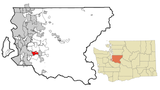
Boulevard Park is a census-designated place (CDP) in King County, Washington, United States. The population was 5,287 at the 2010 census. Boulevard Park was part of the Riverton-Boulevard Park CDP, until it was split for the 2010 census into Riverton and Boulevard Park.
Wilderness Rim is a census-designated place (CDP) in King County, Washington, United States. It lies at an elevation of 1043 ft. The population was 1,523 at the 2010 census.
Bothell East is a census-designated place (CDP) in Snohomish County, Washington, United States. The population was 8,018 at the 2010 census. Bothell East is one of several CDPs that were created out of the former North Creek CDP in 2010.
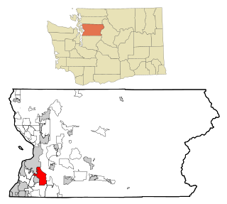
Bothell West is a census-designated place (CDP) in Snohomish County, Washington, United States. The population was 16,607 at the 2010 census. Bothell West is one of several CDPs that were created out of the former North Creek CDP in 2010.
Bunk Foss is a census-designated place (CDP) in Snohomish County, Washington, United States. The population was 3,570 at the 2010 census. Bunk Foss was created out of the former West Lake Stevens CDP in 2010.

Fort Covington Hamlet is a census-designated place (CDP) within the town of Fort Covington, Franklin County, New York, United States. It consists of the hamlet of Fort Covington, as well as a large amount of rural land surrounding the hamlet, such that the CDP occupies about one half of the area within the town limits. The population of the CDP was 1,308 at the 2010 census, out of a total town population of 1,676.