
Kincardineshire, also known as the Mearns, is a historic county, registration county and lieutenancy area on the coast of northeast Scotland. It is bounded by Aberdeenshire on the north and west, and by Angus on the south.

Banchory is a burgh or town in Aberdeenshire, Scotland. It is about 18 miles (29 km) west of Aberdeen, near where the Feugh River meets the River Dee.

The River Dee is a river in Aberdeenshire, Scotland. It rises in the Cairngorms and flows through southern Aberdeenshire to reach the North Sea at Aberdeen. The area it passes through is known as Deeside, or Royal Deeside in the region between Braemar and Banchory because Queen Victoria came for a visit there in 1848 and greatly enjoyed herself. She and her husband, Prince Albert, built Balmoral Castle there, replacing an older castle.

Crathes Castle is a 16th-century castle near Banchory in the Aberdeenshire region of Scotland. It is in the historic county of Kincardineshire. This harled castle was built by the Burnetts of Leys and was held in that family for almost 400 years. The castle and grounds are owned and managed by the National Trust for Scotland and are open to the public.

Peterculter, also known as Culter, is a suburb of Aberdeen, Scotland, about eight miles (13 km) inland from Aberdeen city centre. Peterculter is on the northern banks of the River Dee, near the confluences with Crynoch Burn and Leuchar Burn. Following the 1996 Scottish council boundary changes it became part of the City of Aberdeen's Lower Deeside ward.

Findon(Gaelic: Fionndan Scots: Finnan) is a fishing village eight miles south of Aberdeen, famous for originating the smoked haddock known as Finnan haddie. The Findon moor has a number of paths through it, many of which run along the cliffs. Deer can often be seen there. Nearby features include the Portlethen Moss Nature Reserve.

The Deeside Way is a 41-mile (66 km) rail trail that follows, in part, the bed of the former Deeside Railway in Aberdeenshire. Forming part of the National Cycle Network the trail leads from Aberdeen to Ballater.
Cammachmore is a hamlet in the coastal region near the North Sea in Aberdeenshire. It lies slightly west of the A92 road and the ancient Causey Mounth passes through the community. Historic Elsick House is situated due west of Cammachmore. Other nearby historic features include Gillybrands, Saint Ternan's Church, Muchalls Castle and the Lairhillock Inn.

Banchory-Devenick is a village approximately two kilometres south of the city of Aberdeen, Scotland in the Lower Deeside area of Aberdeenshire. The village should not be confused with the historic civil parish of the same name which spanned the River Dee until 1891, its northern part lying in Aberdeenshire and its southern part in Kincardineshire. In that year the northern part became part of the neighbouring parish of Peterculter, the southern part remaining as the parish of Banchory-Devenick. The village of Banchory-Devenick is on the B9077 road, and the ancient Causey Mounth passes directly through the village. An historic graveyard dating to 1157 AD is present at the village of Banchory-Devenick. Other historic features in the vicinity include Saint Ternan's Church, Muchalls Castle and the Lairhillock Inn.
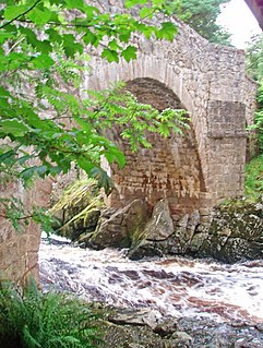
The Water of Feugh is a stream in Aberdeenshire that is the largest tributary to the River Dee. This stream rises in the Grampian Mountains of Scotland, in an area known as the Forest of Birse, and has a particularly scenic aspect in a series of cascades at the Bridge of Feugh slightly above its point of discharge to the Dee.

Milton of Crathes is a complex of restored 17th-century stone buildings, associated with, and previously an outlier of, Crathes Castle in Aberdeenshire, Scotland. The site is presently used for retail and restaurant purposes.

Normandykes is the site of a Roman marching camp 1 mile (1.6 km) to the southwest of Peterculter, City of Aberdeen, Scotland. The near-rectangular site, measuring approximately 860 by 510 metres, covers about 106 acres (43 ha) of the summit and eastern slopes of a hill overlooking the River Dee and the B9077 road further south. Aerial photographs for Normandykes have been archived between 1947 and 1976. The camp is about 6 miles (10 km), or less than half a day's march, north of the Raedykes camp. It is possible that the actual route taken would have entailed one day's march, over a route likely chosen to avoid the Red Moss, a virtually uncrossable bog near the present day village of Netherley. Normandykes was first excavated in the year 1935 by Richmond and MacIntyre; construction is thought to date to the Antonine or Severan periods.

The A957 road, commonly called the Slug Road, is a two lane paved public roadway in Aberdeenshire, Scotland connecting Stonehaven to the A93 road near Crathes after crossing the River Dee, Aberdeenshire over Durris Bridge.

Durris Forest is a chiefly coniferous forest south of the River Dee approximately three kilometres west of Netherley in Aberdeenshire, Scotland. The A957 road forms the southwest boundary of Durris Forest, separating it from Fetteresso Forest. The Durris Forest includes several smaller named woodlands. The ancient route of Elsick Mounth crosses the Grampian Mounth within the Durris Forest. Notable natural features in the vicinity include Red Moss and Meikle Carewe Hill. Notable historic features in this area include Raedykes Roman Camp, Muchalls Castle and Maryculter House.

Milton of Crathes railway station is located at Milton of Crathes, three miles east of Banchory, Royal Deeside, Aberdeenshire, Scotland, United Kingdom.

Deeside is book published in 1911 describing the geography, and history of Deeside, in Aberdeenshire, Scotland.
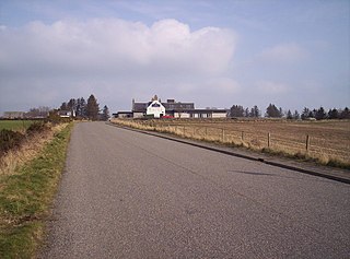
Coalford is a village in Drumoak, Aberdeenshire, Scotland. It is slightly north of the River Dee and about 1 mile (1.6 km) west of Peterculter. The population is around 100.
Balbridie is the site of a Neolithic long house in Aberdeenshire, Scotland, situated on the south bank of the River Dee, east of Banchory. The site is one of the earliest known permanent Neolithic settlements in Scotland, dating from 3400 to 4000 BC. This is the largest Neolithic long house to be excavated in Britain. In a European context, Whittle has indicated the rarity of such large Neolithic timber houses, citing Balbridie, a hall in Cambridgeshire, and Fengate as a small set of such finds.
The B9077 road is a public highway in Aberdeenshire, Scotland that connects the city of Aberdeen to the southern part of Banchory. The road crosses River Dee on the King George VI Bridge in Aberdeen. Outside the city the road has two traffic lanes and runs along the south bank of the River Dee, and in many places provides good views of the river. The road provides access to several historic and prehistoric features in south Deeside including Balbridie, Bucharn and Maryculter House. The highway numbering has been changed since 1985. Other historic features in the general vicinity are Crathes Castle, Milton of Crathes, and Netherley House.

Balfour, Aberdeenshire is a settlement on Royal Deeside in Aberdeenshire, Scotland. Balfour lies south of the River Dee.
