Related Research Articles
Comb Wash is a long narrow valley in south central San Juan County, Utah, United States. It runs from Elk Ridge in the north approximately 35 miles (56 km) to the south, where it merges with the San Juan River at an elevation of about 4,200 feet (1,300 m). The eastern edge of the wash is the Comb Ridge, steep cliffs of Navajo Sandstone, rising in places to 1,000 feet (300 m) above the valley floor.

The Chaco Wash is an arroyo cutting through Chaco Canyon, which is located in northwestern New Mexico on the Colorado Plateau. Another arroyo known as Escavada Wash is a tributary that feeds in from the northeast, near the western end of Chaco Canyon. Chaco Wash flows northwest to become the intermittent Chaco River. It is a tributary of the San Juan River.

Cañada Gobernadora is a tributary to San Juan Creek, about 8.5 miles (13.7 km) long, in southern Orange County in the U.S. state of California. The creek begins in the foothills of the Santa Ana Mountains, at an elevation of 1,040 feet (320 m), and flows south through residential, agricultural and finally undeveloped land, to its confluence with San Juan Creek a few miles upstream of the city of San Juan Capistrano. The upper half of the stream is largely channelized and flows through golf courses, while the lower half is a wash-like channel that can be up to 700 feet (210 m) wide. The stream receives some urban runoff from the residential communities higher in its watershed. The watershed includes several geologic formations, including the Tertiary Sespe Formation and Santiago Formation, and Holocene sedimentary and alluvial deposits embedded in its narrow floodplain. Cañada Gobernadora forms an unofficial dividing line for the lower portion of the San Juan watershed; most urban development is confined to west of the creek's valley, while agricultural and undeveloped lands lie to the east of the creek.
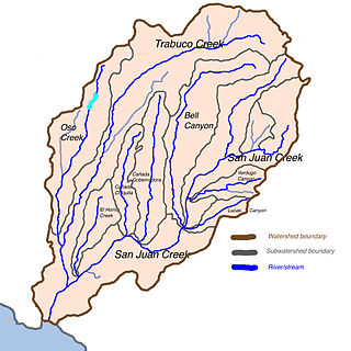
San Juan Creek is a creek in Orange County in the U.S. state of California. It is about 29 miles (47 km) long, and along with its major tributary, Trabuco Creek, drains 133 square miles (340 km2) near the southernmost extent of Orange County. This article describes the course of San Juan Creek.

San Mateo Creek is a stream in Southern California in the United States, whose watershed mostly straddles the border of Orange and San Diego Counties. It is about 22 miles (35 km) long, flowing in a generally southwesterly direction. Draining a broad valley bounded by the Santa Ana Mountains and Santa Margarita Mountains, San Mateo Creek is notable for being one of the last unchannelized streams in Southern California.
The Little Rincon Mountains are a small range of mountains, lying to the east of the Rincon Mountains, at Tucson, of eastern Pima County, Arizona. The range is located in northwest Cochise County and is part of the western border of the San Pedro River and Valley, the major valley and river of western Cochise County. The river is northward flowing to meet the Gila River; its headwaters are south of the US-Mexico border in northern Sonora. A small part of the Little Rincon range's southwest lies in Pima County.
The Carrizo Creek and Carrizo Wash in California are a stream and an arroyo that the stream flows into, in San Diego County, California and Imperial County, California.
San Felipe Creek is a stream in Imperial and San Diego Counties of California. It arises in the Volcan Mountains of San Diego County 33°11′57″N116°37′35″W, and runs eastward, gathering the waters of most of the eastern slope of the mountains and desert of the county in the San Sebastian Marsh before it empties into the Salton Sea. It is probably the last remaining perennial natural desert stream in the Colorado Desert region. In 1974, the San Felipe Creek Area was designated as a National Natural Landmark by the National Park Service.
Hualapai Valley is a valley in Mohave County, Arizona.

Laguña Creek also formerly also known as Tyende Creek, is a stream in the Navajo and Apache Counties of Arizona. Laguña Creek has its source at 36°41′15″N110°30′36″W, at the confluence of Long Canyon and Dowozhiebito Canyon at an elevation of 6,325 feet at the head of Tsegi Canyon. Its mouth is in the Chinle Valley at its confluence with Chinle Wash which together forms Chinle Creek, at an elevation of 4,774 feet. Chinle Creek is a tributary of San Juan River which is in turn a tributary of the Colorado River.

Chinle Creek is a tributary stream of the San Juan River in Apache County, Arizona and San Juan County, Utah. Its source is at 36°53′40″N109°44′37″W, the confluence of Laguña Creek and the Chinle Wash arroyo. Its name is derived from the Navajo word ch'inili meaning 'where the waters came out. Its sources is in Canyon de Chelly National Monument where Canyon de Chelly and Canyon del Muerto have their confluence at an elevation of 5,616 feet at 36°08′35″N109°29′17″W. It then trends northwest to its confluence with Laguña Creek where it forms Chinle Creek, 7 miles northeast of Dennehotso, Arizona at an elevation of 4,774 feet.
Coyote Wash is a tributary stream of Whiskey Creek in the watershed of the San Juan River and Colorado River. The confluence with Whiskey Creek lies within the Canyon de Chelly National Monument. It is entirely in Apache County, Arizona. Its mouth is located at an elevation of 7,080 feet (2,160 m) at its confluence with Whiskey Creek. Its source is at an elevation of 7,096 feet (2,163 m) at the confluence of Crystal Creek and Cattail Wash 36°04′52″N109°08′56″W.
Palm Canyon Wash is an arroyo and tributary ephemeral stream or wash running east from the Jacumba Mountains in San Diego County, California to its confluence with Coyote Wash, east northeast of Ocotillo in the Yuha Desert of Imperial County, California at an elevation of 239 feet / 73 meters. Its source is on the east slope of the Jacumba Mountains at 32°42′28″N116°10′10″W, at an elevation of 4,000 feet.
Palm Canyon Wash is an arroyo and tributary ephemeral stream or wash of the Whitewater River, in Riverside County, California.
Callville Wash is an ephemeral stream or wash in Clark County, Nevada. It was named for Callville the riverport settlement founded in 1866, at its mouth where it had its original confluence with the Colorado River.
Boulder Wash is an ephemeral stream or wash in Clark County, Nevada. Its mouth is at its confluence with the Boulder Wash Cove of Lake Mead at an elevation 1,276 feet at when Lake Mead is at its full level. Currently as the reservoir is at a much lower level its mouth is found at approximately 36°10′07″N114°33′07″W. Its source is at 36°13′36″N114°31′22″W at an elevation of 2,841 feet in the Black Mountains. It flows down a canyon into the upper Pinto Valley southwestward before turning southeastward to Boulder Wash Cove.

Chaco River is a river tributary to the San Juan River in San Juan County, New Mexico. Its mouth lies at an elevation of 4,918 feet. Its source is located at an elevation of 6,050 feet at 36°05′10″N108°00′30″W, its confluence with Chaco Wash and Escavado Wash just northwest of the mouth of Chaco Canyon.
Gillespie Creek is an intermittent stream or arroyo in Hidalgo County, New Mexico. Gillespie Creek is 11 miles long, that heads in the Animas Mountains at 31°37′10″N108°42′40″W, and flows northeasterly until it ends in the Playas Valley, at an elevation of 4,587 feet. Its waters in flood would reach Playas Lake. Its mouth is located 24 miles south southeast of Animas. Bennett Creek is a tributary that has its confluence with Gillespie Creek at 31°38′56″N108°37′23″W an elevation of 4,902 feet.
References
36°10′54″N108°32′41″W / 36.18167°N 108.54472°W