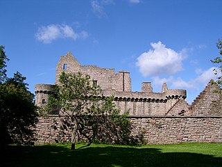
Craigmillar Castle is a ruined medieval castle in Edinburgh, Scotland. It is three miles (4.8 km) south-east of the city centre, on a low hill to the south of the modern suburb of Craigmillar. The Preston family of Craigmillar, the local feudal barons, began building the castle in the late 14th century and building works continued through the 15th and 16th centuries. In 1660, the castle was sold to Sir John Gilmour, Lord President of the Court of Session, who breathed new life into the ageing castle. The Gilmours left Craigmillar in the 18th century for a more modern residence, nearby Inch House, and the castle fell into ruin. It is now in the care of Historic Environment Scotland as a scheduled monument, and is open to the public.
Craiglockhart is a suburb in the south west of Edinburgh, Scotland, lying between Colinton to the south, Morningside to the east Merchiston to the north east, and Longstone and Kingsknowe to the west. The Water of Leith is also to the west.

Muness Castle is located on Unst, which is one of the Shetland Islands of Scotland. The castle is 3 kilometres (1.9 mi) east of the village of Uyeasound. Unst is Scotland's most northerly inhabited island, and Muness is the most northerly fortalice in the British Isles. It was designated as a Scheduled monument in 1953 and is run as a museum by Historic Environment Scotland.

MacLellan's Castle in the town of Kirkcudbright, in Galloway, Scotland, was built in the late 16th century. It stands in the centre of Kirkcudbright, on the south side of the River Dee which flows into the Solway Firth. The L-plan castle was the residence of the MacLellan family from whom it derived its name. The family sold the castle in 1752, and from 1782 to 1912 it was held by the Earls of Selkirk. Today, the site is in the care of Historic Environment Scotland.
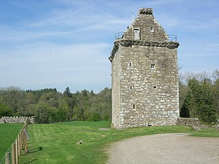
Gilnockie Tower is a 17th-century tower house, located at the hamlet of Hollows, 2.2 km north of Canonbie, in Dumfriesshire, south-west Scotland. The tower is situated on the west bank of the River Esk. It was originally known as Hollows Tower.

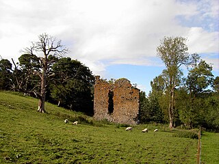
Cousland is a village in Midlothian, Scotland. It is located 4 kilometres (2.5 mi) east of Dalkeith and 3 kilometres (1.9 mi) west of Ormiston, on a hill between the Rivers Tyne and Esk.
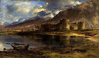
Inverlochy Castle is a ruined, 13th-century castle near Inverlochy and Fort William, Highland, Scotland. The site of two battles, the castle remains largely unchanged since its construction. It is now in the care of Historic Environment Scotland.

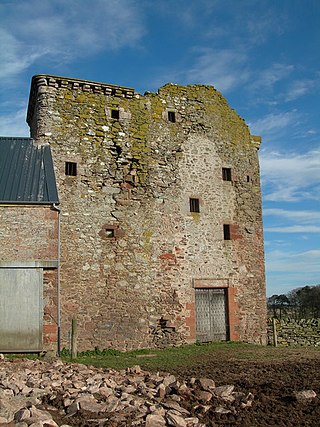
Hawthornden Castle is located on the River North Esk in Midlothian, Scotland. The castle lies a mile to the east of Roslin at grid reference NT287637, and is just downstream from Roslin Castle. Hawthornden comprises a 15th-century ruin, with a 17th-century L-plan house attached. The house has been restored and now serves as a writer's retreat. Man-made caves in the rock beneath the castle have been in use for much longer than the castle itself.

Dryhope Tower is a ruined Scottish peel tower in the valley of the Yarrow Water, in the historic county of Selkirkshire, now part of the Scottish Borders. It lies approximately equidistant between the burghs of Moffat and Selkirk, and defended the north eastern end of St Mary's Loch. The site itself was protected on two sides, to the east by the Dryhope Burn and to the west by the Kirkstead Burn.

Borve Castle, also known as Castle Wearie, and Caisteal Bhuirgh in Scottish Gaelic, is a ruined 14th-century tower house, located at the south-west of the island of Benbecula, in the Western Isles of Scotland. The castle was designated as a Scheduled Monument in 1993.
Nether Horsburgh Castle is a ruined tower house near Cardrona, in the Scottish Borders, in the former county of Peebleshire. It is situated at the back of a farmstead, 3.5 miles (5.6 km) southwest of the market town of Peebles, at grid reference grid reference NT304396, on the A72 road. Access may be gained by permission from the adjoining farmstead, Nether Horsburgh Farm.
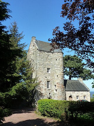
Cramond Tower is a fifteenth-century tower house in the village of Cramond to the north-west of Edinburgh, Scotland.

Drochil Castle is a ruined castle in the Scottish Borders. It is located above the Lyne Water, 10 kilometres (6.2 mi) north-west of Peebles, and 8 kilometres (5.0 mi) south of West Linton.
Wester Kames Castle is located near Kames Bay near Port Bannatyne, Isle of Bute, Scotland. Dating from around 1700, the castle was rebuilt around 1900 from a ruined state.
Brackenhill Tower is a peel tower, in the parish of Arthuret, in Cumbria, just north of the River Lyne. The site is about 2 miles (3.2 km) north of Kirklinton and 4 miles (6.4 km) east of Longtown, or 10 miles (16 km) north of Carlisle and 8 miles (13 km) east of Gretna Green, and is a good defensive position, with ravines to the north and south. Extensions were added in the 18th and 19th centuries, but the original tower has had little alteration. It is the only remaining example of a Scottish tower house south of the border with England, and became a Grade II* listed building in 1957.

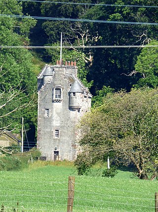
Murieston Castle is a ruined tower house, dating from the 16th century, 2 miles (3.2 km) west of West Calder, west of the Murieston Water, at Murieston Castle Farm, West Lothian, Scotland. It is a scheduled monument and between 1971 and 2018 it was a Category B listed building.
Billie Castle is a ruined 15th-century quadrangular castle, 3 miles (4.8 km) north west of Chirnside, Scottish Borders, Scotland, north of Billiemains. It was designated as a scheduled monument in 1988.

Galdenoch Castle is a tower house near the Scottish village of Leswalt in the Council Area Dumfries and Galloway. The ruin is listed as a Scheduled Monument.
Evelaw Tower is a ruined 16th century tower house, about 2.5 miles (4.0 km) north west of Westruther, Scottish Borders, Scotland, and about 1.5 miles (2.4 km) east of Wedderlie, south of Eve Law.

Dowhill Castle is a ruined castle in Perth and Kinross, Scotland. Sited on a hill near Loch Leven, the oldest part of the castle was built in around 1500 as a tower house. The main structure was extended in around 1600 with additional living space, as well as a tower and turret. The castle had a fortified courtyard (barmkin) to the north with a separate tower. There were probably four storeys but only two still survive.

