Colony houses

Last updated

Colony houses on Collins Place, Stockbridge Stockbridge Colonies.jpg
Colony houses on Collins Place, Stockbridge

The colony houses of Edinburgh were built between 1850 and 1910 as homes for artisans and skilled working-class families by philanthropic model dwellings companies. The first development was the Pilrig Model Buildings, near Leith Walk. [1] Later developments across the city were built by the Edinburgh Cooperative Building Company Limited, founded in 1861. The founders of this company were influenced by the Reverend Dr. James Begg and the Reverend Dr. Thomas Chalmers, ministers of the Free Church of Scotland, who campaigned to improve the housing conditions of the poor. [2]

Contents

Description

Streets with colony houses are found in ten locations within Edinburgh:

The developments at Stockbridge, Dalry, Shaw Colonies, and Rosebank Cottages are category B listed buildings. [3] [4] [5] [6]

Characteristically, each flat originally had four rooms, a separate external toilet and a garden. Colony houses were built as double flats, upper and lower, with the upper flat's front door on the opposite side to the lower flat's front door, allowing each flat to have a front garden.

In some areas, many upper Cottage Flat owners have converted their attic space in to additional living accommodation resulting in the property being more reminiscent of colony houses. In some residential areas such as Colinton Mains, in Edinburgh, a majority of such accommodation has now been converted due to high property prices comparative to the cost of conversion.

History

In 1849, the Pilrig Model Dwellings Company was formed by the Rev. William Garden Blaikie, minister for Pilrig, to build housing for the working classes. [5] The scheme of 44 houses in four blocks was developed by architect Patrick Wilson, and built between 1850 and 1851. Originally known as the Pilrig Model Buildings, the streets were renamed Shaw's Place, Shaw's Street and Shaw's Terrace in 1896. [1]

The second development was at Rosebank Cottages, and was designed by architect Alexander MacGregor for Sir James Gowans. [1] The 36 houses in three rows were based on the Pilrig model, though they added the external stair which is characteristic of the later colonies.

In 1861, a group of builders found themselves locked out of their building sites due to a dispute about working hours. Their three-month ban led to the formation of The Edinburgh Co-operative Building Company Ltd (ECBC). This group comprised many different trades - stonemasons, plasterers, plumbers and others sympathetic to their aims. Central to its mission was a co-operative spirit that was reflected in its adoption of the beehive motif. The company's first site was at Glenogle Park, by the Water of Leith near Stockbridge, where the foundation stone was laid on 23 October 1861. [3] The layout of 11 terraces took the Rosebank development as its prototype, and was mostly complete by 1872. [1]

While the building lock out provided the opportunity for tradesmen to form a company, it was the poor state of housing in the old town which was the underlying stimulus for the foundation of the ECBC, whose stated intention was to build houses for sale to working people. A newspaper from 1870 reports:

"The entire capital [of the Company] is subscribed by 836 members, 400 houses supplying healthful accommodation for at least 2,000 individuals, have been built and sold for £70,000; and an average profit of over 15 per cent has been paid every year." [7]

ECBC also constructed the Dalry Colonies at Haymarket, from 1868 to 1870, largely to house the employees of the Caledonian Railway. [1] By 1911 over 2,000 houses had been constructed on eleven sites. Many were owned by the artisan classes in an era when mortgages did not exist. The earliest residents of the colonies were skilled workers and artisan builders and this remained the largest occupational group for much of the 20th century. The Abbeyhill colonies in particular had a number of railway workers due to the proximity of the area to the line. Persistence of inhabitants was also a key feature of colony life, which made for stable neighbourhoods. The design of the buildings did result in a certain amount of overlooking and gossiping, but this feature has also contributed to a sense of identity and community that is quite unique in Edinburgh.

See also

Related Research Articles

<span class="mw-page-title-main">Stockbridge, Edinburgh</span> Suburb in Scotland

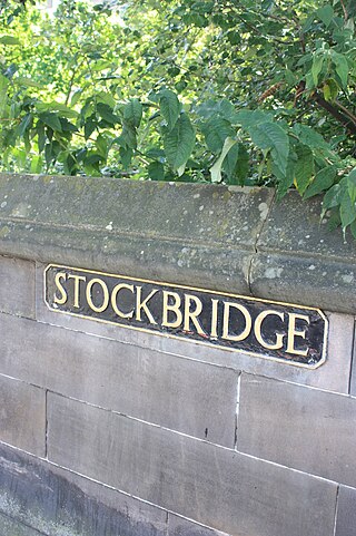
Stockbridge is a suburb of Edinburgh, located north of the city centre, bounded by the New Town and by Comely Bank. The name is Scots stock brig from Anglic stocc brycg, meaning a timber bridge. Originally a small outlying village, it was incorporated into the City of Edinburgh in the 19th century. The current "Stock Bridge", built in 1801, is a stone structure spanning the Water of Leith. The painter Henry Raeburn (1756–1823) owned two adjoining estates, Deanhaugh and St Bernard's, which he developed with the assistance of the architect James Milne. Milne was also responsible for the fine St Bernard's Church (1823) in Saxe Coburg Street. Ann Street, designed by Raeburn and named after his wife, is a rare early example of a New Town street with private front gardens.

<span class="mw-page-title-main">Dalry, Edinburgh</span> Human settlement in Scotland

Dalry is an area of the Scottish capital city of Edinburgh. It is located close to the city centre, between Haymarket and Gorgie. The area is now primarily residential. It is centred around Dalry Road, which has numerous shops, restaurants and small businesses. Lying outside the old city walls and west of the castle, the area began as part of the agricultural estate of Dalry House, the exception being the Dalry Mill, recorded as the oldest paper mill in Scotland, now demolished.

<span class="mw-page-title-main">Abbeyhill</span>

Abbeyhill is an area of Edinburgh, the capital of Scotland.

Sighthill is a suburb in the west of Edinburgh, Scotland. The area is bordered by Broomhouse and Parkhead to the east, South Gyle to the north, the industrial suburb of Bankhead and the Calders neighbourhood to the west, and Wester Hailes to the south. It is sometimes included in the Wester Hailes area, while the Calders, Bankhead and Parkhead are sometimes considered parts of Sighthill. Administratively it has formed a core part of the City of Edinburgh Council's Sighthill/Gorgie ward since 2007.

<span class="mw-page-title-main">Cottage flat</span> Housing style in the United Kingdom

Cottage flats, also known as four-in-a-block flats, are a style of housing common in Scotland, where there are single floor dwellings at ground level, and similar dwellings on the floor above. All have doors directly to the outside of the building, rather than into a 'close', or common staircase, although some do retain a shared entrance. The name 'cottage flats' is confusing as before the mid-1920s cottage housing referred to a single house, normally semi-detached which contained living accommodation downstairs and bedrooms above. These were phased out by most urban local authorities as wasteful of space and economy after central government subsidies were reduced in the 1924 Housing Act.

<span class="mw-page-title-main">Granton, Edinburgh</span> Edinburgh suburb

Granton is a district in the north of Edinburgh, Scotland. Granton forms part of Edinburgh's waterfront along the Firth of Forth and is, historically, an industrial area having a large harbour. Granton is part of Edinburgh's large scale waterfront regeneration programme.

<span class="mw-page-title-main">Pilrig</span> Suburb of Edinburgh, Scotland

Pilrig is an area of Edinburgh, the capital of Scotland. The name probably derives from the long field (rig) on which a peel tower (pil/peel) stood. There is evidence of a peel tower situated on an area of higher ground above the Water of Leith.

<span class="mw-page-title-main">Restalrig</span> Human settlement in Scotland

Restalrig is a small residential suburb of Edinburgh, Scotland. It is located east of the city centre, west of Craigentinny and to the east of Lochend, both of which it overlaps. Restalrig Road is the main route through the area, running from London Road, at Jock's Lodge, to Leith Links. It is in the ward of Lochend.

<span class="mw-page-title-main">Leith Walk</span> Street in Edinburgh, Scotland

Leith Walk is one of the longest streets in Edinburgh, Scotland, and is the main road connecting the centre of the city to Leith. Forming most of the A900 road, it slopes downwards from Picardy Place at the south-western end of the street to the 'Foot of the Walk' at the north-eastern end, where Great Junction Street, Duke Street, Constitution Street and the Kirkgate meet.

Shandon is an area of Edinburgh within North Merchiston approximately three miles west of the centre of Edinburgh. It is bounded by Slateford Road to the north, Harrison Road to the east, the Union Canal to the south and the Glasgow-Edinburgh Shotts Line and Suburban rail lines to the west.

<span class="mw-page-title-main">West End, Edinburgh</span> Human settlement in Scotland

The West End is an affluent district of Edinburgh, Scotland, which along with the rest of the New Town and Old Town forms central Edinburgh, and Edinburgh's UNESCO World Heritage Site. The area boasts several of the city's hotels, restaurants, independent shops, offices and arts venues, including the Edinburgh Filmhouse, Edinburgh International Conference Centre and the Caledonian Hotel. The area also hosts art festivals and crafts fairs.

<span class="mw-page-title-main">Rosebank Cemetery</span> Cemetery in Edinburgh, Scotland

Rosebank Cemetery is a 19th-century cemetery in Edinburgh. It is located at the junction of Pilrig Street and Broughton Road in the Pilrig area, close to the historical boundary of Leith. The cemetery is protected as a category C listed building.

Edinburgh and District Tramways operated a tramway service in Edinburgh between 1893 and 1919, and Leith between 1871 and 1904.

<span class="mw-page-title-main">Robert Morham</span>

Robert Morham was the City Architect for Edinburgh for the last decades of the nineteenth century and was responsible for much of the “public face” of the city at the time.

<span class="mw-page-title-main">David Cousin</span> Scottish architect (1809-1878)

David Cousin was a Scottish architect, landscape architect and planner, closely associated with early cemetery design and many prominent buildings in Edinburgh. From 1841 to 1872 he operated as Edinburgh’s City Superintendent of Works.

<span class="mw-page-title-main">Patrick Wilson (architect)</span> British architect

Patrick Wilson was a British architect with a long career spanning across the 19th century from the Georgian aesthetic to the Victorian. He was a strong advocate of purpose-built housing for the poor working closely with the Rev. Thomas Chalmers. Most of his works are in Edinburgh, the most notable of which is the first ever colony style housing in the city, the Shaw Colonies, a very innovative building form.

Duncan Menzies (1837-1910) was a Scottish architect and civil engineer. His best known work is the Turnberry Hotel in Ayrshire. His grandest scheme is Murrayfield Avenue in west Edinburgh.

Bellevue is a district of Edinburgh, the capital of Scotland. It lies to the south east of Canonmills, west of Leith Walk and south of Leith, incorporating the easternmost extent of Edinburgh's New Town UNESCO heritage site. The area was formerly open fields which became the second and penultimate location of the Royal Botanic Garden in 1763 .

References

  1. 1 2 3 4 5 "Colonies" (PDF). Edinburgh Colonies Conservation Area Character Appraisal. City of Edinburgh Council. February 2014. Retrieved 7 September 2016.
  2. "Pathfinder Pack on Housing, 1850 - 1875". Resources for Learning in Scotland. Retrieved 12 March 2010.
  3. 1 2 Historic Environment Scotland. "GLENOGLE ROAD, GLENOGLE PARK (THE COLONIES), 1-40 (INCLUSIVE) REID TERRACE AND 1-8 (INCLUSIVE) BRIDGE PLACE (Category B Listed Building) (LB50525)" . Retrieved 18 March 2019.
  4. Historic Environment Scotland. "DALRY PLACE, THE DALRY TERRS; DALRY RD 15-29 & 31-47 WALKER TERR 9-16 LEWIS TERR 9-16 COBDEN TERR 1-16 DOUGLAS TERR 1-16 BRIGHT TERR 1-16, ARGYLL TERR 1-16 MCLAREN TERR 1-10 ATHOLL TERR 1-16, BREADALBANE TERR 1-18 WITH RAILGS & GRDN WALLS (Category B Listed Building) (LB26746)" . Retrieved 18 March 2019.
  5. 1 2 Historic Environment Scotland. "1-28 (INCLUSIVE NOS) SHAW'S STREET, 1-10 (INCLUSIVE NOS) SHAW'S PLACE AND 1-18 (INCLUSIVE NOS) SHAW'S TERRACE (Category B Listed Building) (LB45961)" . Retrieved 18 March 2019.
  6. Historic Environment Scotland. "1-36 (INCLUSIVE NOS) ROSEBANK COTTAGES, INCLUDING BOUNDARY WALLS (Category B Listed Building) (LB29656)" . Retrieved 18 March 2019.
  7. "Reid Terrace". EdinPhoto. Retrieved 12 March 2010.